Lêer:Map_Bih_entities.png
From Wikipedia, the free encyclopedia
Grootte van hierdie voorskou: 633 × 599 piksels. Ander resolusies: 254 × 240 piksels | 507 × 480 piksels | 811 × 768 piksels | 1 103 × 1 044 piksels.
Oorspronklike lêer (1 103 × 1 044 piksels, lêergrootte: 67 KG, MIME-tipe: image/png)
Hierdie lêer kom vanaf Wikimedia Commons en kan ook in ander projekte gebruik word. Die beskrywing op die lêer se inligtingsblad word hieronder weergegee.
Opsomming
| BeskrywingMap Bih entities.png |
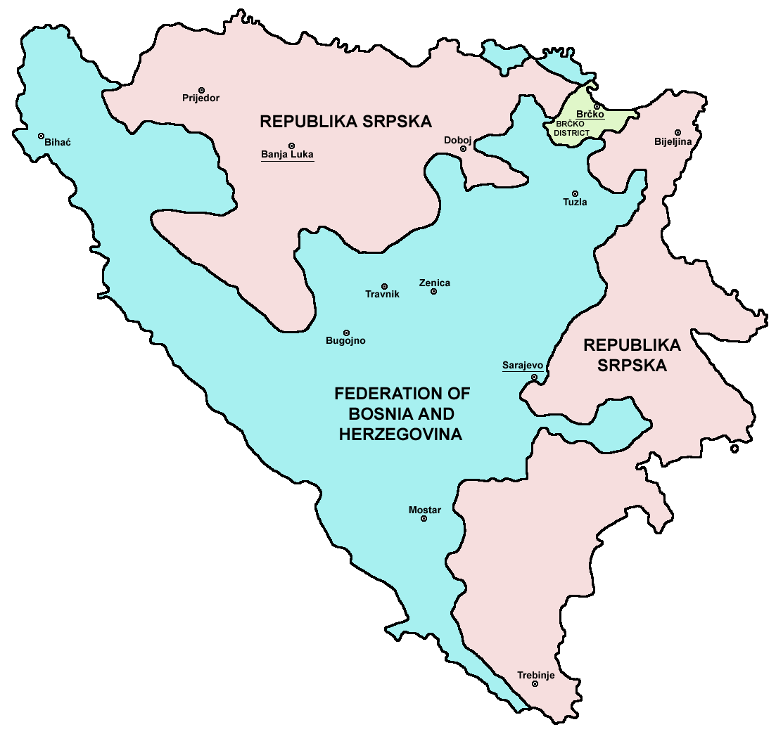
Srpskohrvatski / српскохрватски: Federacija Bosne i Hercegovine, Republika Srpska i Distrikt Brčko / Федерација Босне и Херцеговине, Република Српска и Дистрикт Брчко. |
| Datum | |
| Bron | en:Image:M_bih03.png |
| Outeur | User:PANONIAN |
| Ander weergawes |
[wysig]
|


.png)


References
- Slobodan Radovanović, Geografski atlas, Magic Map, Smederevska Palanka, 2001.
- Geografski atlas, Intersistem kartografija, Beograd, 2004.
- http://www.mapsofworld.com/bosnia/maps/bosnia-herzegovina-map.jpg
- http://www.slobodanjovanovic.org/wp-content/uploads/2009/12/bosna-kantoni1.jpg
- http://www.thomasgraz.net/glass/map-BIH.gif
- http://aceproject.org/ero-en/regions/europe/BA/doc1.jpg/image
- United States Department of State
- http://www.visitbosnia.org/bih/images/stories/o_bih/drzavno_uredjenje/entiteti.jpg[dead link]
- http://www.conflictgeographies.org/uploads/2/6/1/8/2618869/8958714.jpg?490 archive copy at the Wayback Machine
- http://vozi.org/images/stories/broj%20registrovanih%20vozila%202010.godina.png
- http://www.ohr.int/ohr-offices/brcko/images/map-brcko-district.jpg
- http://www.ohr.int/ohr-offices/brcko/images/mapa%20BD.JPG
- http://www.conflictgeographies.org/uploads/2/6/1/8/2618869/388168.jpg?490 archive copy at the Wayback Machine
- http://world-gazetteer.com/ archive copy at the Wayback Machine
Lisensiëring
| Public domainPublic domainfalsefalse |
| Ek, die outeursreghouer van hierdie werk, stel dit hiermee in die publieke domein vry. Dit geld wêreldwyd. In sommige lande is dit dalk nie wettiglik moontlik nie. Indien so: Ek verleen aan enigiemand die reg om hierdie werk te gebruik vir enige doel, sonder voorwaardes, tensy sulke voorwaardes deur die wet vereis word. |

|
This map image could be re-created using vector graphics as an SVG file. This has several advantages; see Commons:Media for cleanup for more information. If an SVG form of this image is available, please upload it and afterwards replace this template with
{{vector version available|new image name}}.
It is recommended to name the SVG file “Map Bih entities.svg”—then the template Vector version available (or Vva) does not need the new image name parameter. |
Captions
Add a one-line explanation of what this file represents
Items portrayed in this file
uitbeelding
28 Januarie 2006
media type Engels
image/png
Lêergeskiedenis
Klik op die datum/tyd om te sien hoe die lêer destyds gelyk het.
| Datum/Tyd | Duimnael | Dimensies | Gebruiker | Opmerking | |
|---|---|---|---|---|---|
| huidig | 21:38, 6 Julie 2010 | | 1 103 × 1 044 (67 KG) | PANONIAN | Reverted to version as of 23:51, 12 March 2010 - I do not agree that these are better colours. it is subjective opinion and it is bad idea that every user should upload new file version because he have different opinion about "better" colours |
| 12:26, 6 Julie 2010 |  | 1 103 × 1 044 (58 KG) | Mostarac | better colors | |
| 12:25, 6 Julie 2010 |  | 1 103 × 1 044 (58 KG) | Mostarac | better colors and cities. | |
| 23:51, 12 Maart 2010 |  | 1 103 × 1 044 (67 KG) | Dungodung | Well, I beg to differ. This one shows cities and is of better quality | |
| 11:55, 9 Maart 2010 |  | 700 × 615 (172 KG) | Mostarac | revert, bolje boje! | |
| 21:10, 20 Desember 2009 |  | 1 103 × 1 044 (67 KG) | PANONIAN | improved version | |
| 08:05, 16 Julie 2007 |  | 700 × 615 (13 KG) | Nihad Hamzic | This image was once a JPEG, the author had simply directly converted it to JPEG. I have grealty optimised its size by removing JPEG artifacts, and reducing color domain. | |
| 22:42, 28 Januarie 2006 |  | 700 × 615 (172 KG) | (:Julien:) | Map of the 2 entities of the BiH and the Brčko district, author: en:User:PANONIAN, source: en:Image:M_bih03.png, PANONIAN is the creator and released it under PD. Category:Bosnia and Herzegovina |
Lêergebruik
Die volgende bladsy gebruik dié lêer:
Globale lêergebruik
Die volgende ander wiki's gebruik hierdie lêer:
- Gebruik in ami.wikipedia.org
- Gebruik in am.wikipedia.org
- Gebruik in arc.wikipedia.org
- Gebruik in ar.wikipedia.org
- Gebruik in arz.wikipedia.org
- Gebruik in ast.wikipedia.org
- Gebruik in az.wikipedia.org
- Gebruik in bat-smg.wikipedia.org
- Gebruik in be-tarask.wikipedia.org
- Gebruik in bi.wikipedia.org
- Gebruik in bjn.wikipedia.org
- Gebruik in bn.wikipedia.org
- Gebruik in bo.wikipedia.org
- Gebruik in bpy.wikipedia.org
- Gebruik in br.wikipedia.org
- Gebruik in bs.wikipedia.org
- Gebruik in ca.wikipedia.org
- Gebruik in ceb.wikipedia.org
- Gebruik in ce.wikipedia.org
- Gebruik in ckb.wikipedia.org
- Gebruik in co.wikipedia.org
- Gebruik in crh.wikipedia.org
- Gebruik in csb.wikipedia.org
- Gebruik in cs.wikipedia.org
- Gebruik in cs.wikinews.org
- Gebruik in cv.wikipedia.org
- Gebruik in cy.wikipedia.org
- Gebruik in da.wikipedia.org
- Gebruik in de.wikipedia.org
- Gebruik in diq.wikipedia.org
- Gebruik in dv.wikipedia.org
- Gebruik in ee.wikipedia.org
- Gebruik in el.wikipedia.org
- Gebruik in en.wikipedia.org
- Bosnia and Herzegovina
- History of Bosnia and Herzegovina
- Multinational state
- Republika Srpska (1992–1995)
- Inter-Entity Boundary Line
- Talk:Inter-Entity Boundary Line
- Portal:Bosnia and Herzegovina
- User:Jonny-mt/Gallery of current first-level administrative country subdivisions maps
- Politics of country subdivisions
- Talk:Federation of Bosnia and Herzegovina/Archive 1
- User:Falcaorib/Serbia, Yugoslavia and Albania
- Gebruik in en.wikivoyage.org
Wys meer globale gebruik van die lêer.
Ontsluit van "https://af.wikipedia.org/wiki/Lêer:Map_Bih_entities.png"