Restr:Map_Bih_entities.png
From Wikipedia, the free encyclopedia
Ment ar rakweled-mañ : 633 × 599 piksel. pizhderioù all : 254 × 240 piksel | 507 × 480 piksel | 811 × 768 piksel | 1 103 × 1 044 piksel.
Restr orin (1 103 × 1 044 piksel, ment ar restr : 67 Kio, seurt MIME : image/png)
![]()
| Tennet eo ar restr-mañ eus Wikimedia Commons ha gallout a ra bezañ implijet evit raktresoù all. Diskouezet eo deskrivadur he fajenn zeskrivañ amañ dindan. |
Diverradur
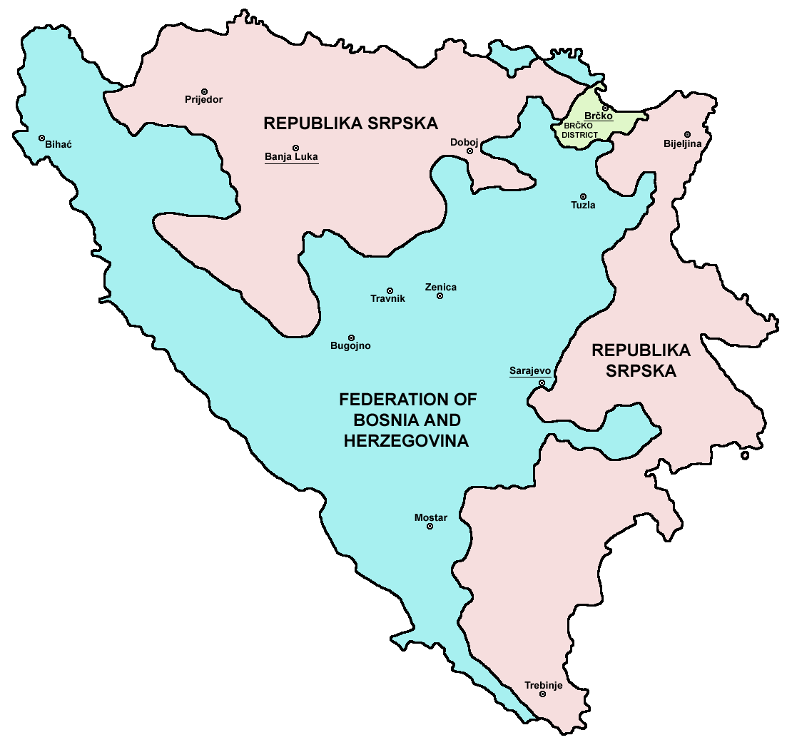
| DeskrivadurMap Bih entities.png |
Srpskohrvatski / српскохрватски: Federacija Bosne i Hercegovine, Republika Srpska i Distrikt Brčko / Федерација Босне и Херцеговине, Република Српска и Дистрикт Брчко. |
| Deiziad | |
| Mammenn | en:Image:M_bih03.png |
| Aozer | User:PANONIAN |
| Stummoù all |
[kemmañ]
|


.png)


References
- Slobodan Radovanović, Geografski atlas, Magic Map, Smederevska Palanka, 2001.
- Geografski atlas, Intersistem kartografija, Beograd, 2004.
- http://www.mapsofworld.com/bosnia/maps/bosnia-herzegovina-map.jpg
- http://www.slobodanjovanovic.org/wp-content/uploads/2009/12/bosna-kantoni1.jpg
- http://www.thomasgraz.net/glass/map-BIH.gif
- http://aceproject.org/ero-en/regions/europe/BA/doc1.jpg/image
- United States Department of State
- http://www.visitbosnia.org/bih/images/stories/o_bih/drzavno_uredjenje/entiteti.jpg[dead link]
- http://www.conflictgeographies.org/uploads/2/6/1/8/2618869/8958714.jpg?490 archive copy at the Wayback Machine
- http://vozi.org/images/stories/broj%20registrovanih%20vozila%202010.godina.png
- http://www.ohr.int/ohr-offices/brcko/images/map-brcko-district.jpg
- http://www.ohr.int/ohr-offices/brcko/images/mapa%20BD.JPG
- http://www.conflictgeographies.org/uploads/2/6/1/8/2618869/388168.jpg?490 archive copy at the Wayback Machine
- http://world-gazetteer.com/ archive copy at the Wayback Machine
Aotre-implijout
| Public domainPublic domainfalsefalse |
| Me, perc'henn war gwirioù an oberenn-mañ, a laka anezhi en domani foran. Talvezout a ra kement-mañ evit ar bed a-bezh. E broioù zo e c'hall kement-mañ bezañ dibosupl ent lezennel; mard emañ kont evel-se : Reiñ a ran aotre d'an holl da implijout an oberenn-mañ evit ober ne vern petra, hep tamm bevenn ebet estreget hini al lezenn. |

|
This map image could be re-created using vector graphics as an SVG file. This has several advantages; see Commons:Media for cleanup for more information. If an SVG form of this image is available, please upload it and afterwards replace this template with
{{vector version available|new image name}}.
It is recommended to name the SVG file “Map Bih entities.svg”—then the template Vector version available (or Vva) does not need the new image name parameter. |
Captions
Add a one-line explanation of what this file represents
Items portrayed in this file
diskouez a ra
28 Gen 2006
image/png
Istor ar restr
Klikañ war un deiziad/eur da welet ar restr evel ma oa da neuze.
| Deiziad/Eur | Munud | Mentoù | Implijer | Notenn | |
|---|---|---|---|---|---|
| red | 6 Gou 2010 da 21:38 | | 1 103 × 1 044 (67 Kio) | PANONIAN | Reverted to version as of 23:51, 12 March 2010 - I do not agree that these are better colours. it is subjective opinion and it is bad idea that every user should upload new file version because he have different opinion about "better" colours |
| 6 Gou 2010 da 12:26 |  | 1 103 × 1 044 (58 Kio) | Mostarac | better colors | |
| 6 Gou 2010 da 12:25 |  | 1 103 × 1 044 (58 Kio) | Mostarac | better colors and cities. | |
| 12 Meu 2010 da 23:51 |  | 1 103 × 1 044 (67 Kio) | Dungodung | Well, I beg to differ. This one shows cities and is of better quality | |
| 9 Meu 2010 da 11:55 |  | 700 × 615 (172 Kio) | Mostarac | revert, bolje boje! | |
| 20 Kzu 2009 da 21:10 |  | 1 103 × 1 044 (67 Kio) | PANONIAN | improved version | |
| 16 Gou 2007 da 08:05 |  | 700 × 615 (13 Kio) | Nihad Hamzic | This image was once a JPEG, the author had simply directly converted it to JPEG. I have grealty optimised its size by removing JPEG artifacts, and reducing color domain. | |
| 28 Gen 2006 da 22:42 |  | 700 × 615 (172 Kio) | (:Julien:) | Map of the 2 entities of the BiH and the Brčko district, author: en:User:PANONIAN, source: en:Image:M_bih03.png, PANONIAN is the creator and released it under PD. Category:Bosnia and Herzegovina |
Implij ar restr
Implijout a ra ar bajenn da heul ar restr-mañ :
Implij hollek ar restr
Ober a ra ar wikioù da-heul gant ar restr-mañ :
- Implij war af.wikipedia.org
- Implij war ami.wikipedia.org
- Implij war am.wikipedia.org
- Implij war arc.wikipedia.org
- Implij war ar.wikipedia.org
- Implij war arz.wikipedia.org
- Implij war ast.wikipedia.org
- Implij war az.wikipedia.org
- Implij war bat-smg.wikipedia.org
- Implij war be-tarask.wikipedia.org
- Implij war bi.wikipedia.org
- Implij war bjn.wikipedia.org
- Implij war bn.wikipedia.org
- Implij war bo.wikipedia.org
- Implij war bpy.wikipedia.org
- Implij war bs.wikipedia.org
- Implij war ca.wikipedia.org
- Implij war ceb.wikipedia.org
- Implij war ce.wikipedia.org
- Implij war ckb.wikipedia.org
- Implij war co.wikipedia.org
- Implij war crh.wikipedia.org
- Implij war csb.wikipedia.org
- Implij war cs.wikipedia.org
- Implij war cs.wikinews.org
- Implij war cv.wikipedia.org
- Implij war cy.wikipedia.org
- Implij war da.wikipedia.org
- Implij war de.wikipedia.org
- Implij war diq.wikipedia.org
- Implij war dv.wikipedia.org
- Implij war ee.wikipedia.org
- Implij war el.wikipedia.org
- Implij war en.wikipedia.org
- Bosnia and Herzegovina
- History of Bosnia and Herzegovina
- Multinational state
- Republika Srpska (1992–1995)
- Inter-Entity Boundary Line
- Talk:Inter-Entity Boundary Line
- Portal:Bosnia and Herzegovina
- User:Jonny-mt/Gallery of current first-level administrative country subdivisions maps
- Politics of country subdivisions
- Talk:Federation of Bosnia and Herzegovina/Archive 1
- User:Falcaorib/Serbia, Yugoslavia and Albania
- Implij war en.wikivoyage.org
Gwelet muioc'h eus implij hollek ar restr-mañ.
Adtapet diwar « https://br.wikipedia.org/wiki/Restr:Map_Bih_entities.png »