Delwedd:Mediterranean_Relief.jpg
From Wikipedia, the free encyclopedia
Maint llawn ((1,308 × 733 picsel, maint y ffeil: 635 KB, ffurf MIME: image/jpeg))
Daw'r ffeil hon o Comin Wikimedia a gellir ei defnyddio gan brosiectau eraill. Dangosir isod y disgrifiad sydd ar dudalen ddisgrifio'r ffeil yno.

|
This map image could be re-created using vector graphics as an SVG file. This has several advantages; see Commons:Media for cleanup for more information. If an SVG form of this image is available, please upload it and afterwards replace this template with
{{vector version available|new image name}}.
It is recommended to name the SVG file “Mediterranean Relief.svg”—then the template Vector version available (or Vva) does not need the new image name parameter. |
 | This map image was uploaded in the JPEG format even though it consists of non-photographic data. This information could be stored more efficiently or accurately in the PNG or SVG format. If possible, please upload a PNG or SVG version of this image without compression artifacts, derived from a non-JPEG source (or with existing artifacts removed). After doing so, please tag the JPEG version with {{Superseded|NewImage.ext}} and remove this tag. This tag should not be applied to photographs or scans. If this image is a diagram or other image suitable for vectorisation, please tag this image with {{Convert to SVG}} instead of {{BadJPEG}}. If not suitable for vectorisation, use {{Convert to PNG}}. For more information, see {{BadJPEG}}. |  |
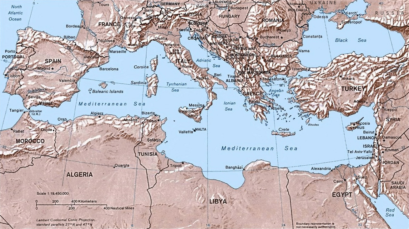
- Shaded relief Map of the Mediterranean Sea - and its Basin and Landforms.
- The original map was created in 1982 by the Central Intelligence Agency ([1], specifically [2]).
- This version was produced by w:User:Joy, who originally uploaded it to the English Wikipedia:
- 23:46, 28 Sep 2004 . . Joy (343433 bytes) (an update after 22 years :) added borders and names for the ex-yu republics (si,hr,ba,cs,mk); corrected names for de,sk; dropped su name but didn't bother drawing the md/uk/ru borders or names because they're not near the topic at hand, and it's tiresome)
| Public domainPublic domainfalsefalse |
This work is in the public domain in the United States because it is a work prepared by an officer or employee of the United States Government as part of that person’s official duties under the terms of Title 17, Chapter 1, Section 105 of the US Code.
Note: This only applies to original works of the Federal Government and not to the work of any individual U.S. state, territory, commonwealth, county, municipality, or any other subdivision. This template also does not apply to postage stamp designs published by the United States Postal Service since 1978. (See § 313.6(C)(1) of Compendium of U.S. Copyright Office Practices). It also does not apply to certain US coins; see The US Mint Terms of Use.
|
 | |
| Canfyddwyd bod y ffeil yn rhydd o gyfyngiadau yn ôl cyfraith hawlfraint, gan gynnwys pob hawl perthynol a chyfagos. | ||
https://creativecommons.org/publicdomain/mark/1.0/PDMCreative Commons Public Domain Mark 1.0falsefalse
Captions
Items portrayed in this file
yn portreadu
media type Saesneg
image/jpeg
Hanes y ffeil
Cliciwch ar ddyddiad / amser i weld y ffeil fel ag yr oedd bryd hynny.
| Dyddiad / Amser | Bawdlun | Hyd a lled | Defnyddiwr | Sylw | |
|---|---|---|---|---|---|
| cyfredol | 14:32, 6 Mai 2016 | | 1,308 × 733 (635 KB) | Julieta39 | Actualised the borders |
| 21:38, 30 Mai 2015 |  | 1,308 × 733 (614 KB) | Subtropical-man | Reverted to version as of 18:25, 29 August 2011 | |
| 00:59, 1 Medi 2011 |  | 1,428 × 800 (400 KB) | Gwillhickers | Larger image, better sharpness | |
| 00:58, 1 Medi 2011 |  | 1,428 × 800 (400 KB) | Gwillhickers | Larger ima | |
| 18:25, 29 Awst 2011 |  | 1,308 × 733 (614 KB) | Subtropical-man | ||
| 22:21, 24 Awst 2011 |  | 1,428 × 800 (400 KB) | Gwillhickers | better sharpness, color tone | |
| 01:01, 27 Mehefin 2010 |  | 1,308 × 733 (614 KB) | Ras67 | rotated and cropped | |
| 20:22, 4 Mehefin 2010 |  | 1,325 × 739 (288 KB) | Cropbot | upload cropped version, operated by User:diaa_abdelmoneim. Summary: cropped | |
| 19:22, 21 Rhagfyr 2005 |  | 1,332 × 792 (274 KB) | Lhgodoy~commonswiki | Noise removal in original image | |
| 20:59, 4 Rhagfyr 2004 |  | 1,332 × 792 (335 KB) | Alfio | Map of the Mediterranean Sea |
Cysylltiadau'r ffeil
Mae'r 1 tudalennau a ddefnyddir isod yn cysylltu i'r ddelwedd hon:
Defnydd cydwici y ffeil
Mae'r wicis eraill hyn yn defnyddio'r ffeil hon:
- Y defnydd ar af.wikipedia.org
- Y defnydd ar am.wikipedia.org
- Y defnydd ar arc.wikipedia.org
- Y defnydd ar ar.wikipedia.org
- Y defnydd ar arz.wikipedia.org
- Y defnydd ar ast.wikipedia.org
- Y defnydd ar as.wikipedia.org
- Y defnydd ar az.wikipedia.org
- Y defnydd ar az.wiktionary.org
- Y defnydd ar be.wikipedia.org
- Y defnydd ar bo.wikipedia.org
- Y defnydd ar bs.wikipedia.org
- Y defnydd ar ca.wikipedia.org
- Y defnydd ar ceb.wikipedia.org
- Y defnydd ar cv.wikipedia.org
- Y defnydd ar da.wikipedia.org
- Y defnydd ar de.wikipedia.org
- Y defnydd ar dsb.wikipedia.org
- Y defnydd ar dty.wikipedia.org
- Y defnydd ar el.wikipedia.org
- Y defnydd ar en.wikipedia.org
- Y defnydd ar en.wiktionary.org
- Y defnydd ar eo.wikipedia.org
- Y defnydd ar es.wikipedia.org
- Y defnydd ar es.wikibooks.org
Gweld rhagor o'r defnydd cydwici o'r ffeil hon.
Metadata
Mae'r ffeil hon yn cynnwys gwybodaeth ychwanegol, sydd mwy na thebyg wedi dod o'r camera digidol neu'r sganiwr a ddefnyddiwyd i greu'r ffeil neu ei digido. Os yw'r ffeil wedi ei cael ei newid ers ei chreu efallai nad yw'r manylion hyn yn dal i fod yn gywir.
| Gogwydd | Normal |
|---|---|
| Datrysiad llorweddol | 72 dpi |
| Datrysiad fertigol | 72 dpi |
| Meddalwedd a ddefnyddir | Adobe Photoshop CS3 Macintosh |
| Dyddiad ac amser y newidiwyd y ffeil ddiwethaf | 15:28, 18 Ebrill 2016 |
| Gofod lliw | Heb ei raddnodi |
| Lled y ddelwedd | 1,308 px |
| Uchder y ddelwedd | 733 px |
| Dyddiad ac amser y digido | 16:27, 14 Ebrill 2016 |
| Y dyddiad y newidiwyd y metadata ddiwethaf | 17:28, 18 Ebrill 2016 |