File:Britain-fractal-coastline-combined.jpg
From Wikipedia, the free encyclopedia
No higher resolution available.
Britain-fractal-coastline-combined.jpg (451 × 289 pixels, file size: 33 KB, MIME type: image/jpeg)
| This is a file from the Wikimedia Commons. Information from its description page there is shown below. Commons is a freely licensed media file repository. You can help. |
| DescriptionBritain-fractal-coastline-combined.jpg |
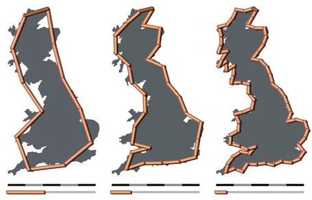
English: The coastline of the United Kingdom as measured with measuring rods of 200 km, 100 km and 50 km in length. The resulting coastline is about 2350 km, 2775 km and 3425 km; the shorter the scale, the longer the measured length of the coast.
Deutsch: Die Küstenlinie Vereinigtes Königreich bei Messung mit unterschliedlich langen Messstäben von 200 km, 100 km und 50 km Länge. Die resultierende Küstenlänge beträgt ungefähr 2350 km, 2775 km bzw. 3425 km, d.h. je kürzer der Massstab, desto länger wird die ermittelte Länge der Küste. |
||||||||
| Date | 6 May 2005 (upload date) | ||||||||
| Source |
own work by Avsa
|
||||||||
| Author |
originals made by Avsa mixed by Acadac |
||||||||
| Permission (Reusing this file) |
|
||||||||
| Other versions |
|


|
This map image could be re-created using vector graphics as an SVG file. This has several advantages; see Commons:Media for cleanup for more information. If an SVG form of this image is available, please upload it and afterwards replace this template with
{{vector version available|new image name}}.
It is recommended to name the SVG file “Britain-fractal-coastline-combined.svg”—then the template Vector version available (or Vva) does not need the new image name parameter. |
 | This map image was uploaded in the JPEG format even though it consists of non-photographic data. This information could be stored more efficiently or accurately in the PNG or SVG format. If possible, please upload a PNG or SVG version of this image without compression artifacts, derived from a non-JPEG source (or with existing artifacts removed). After doing so, please tag the JPEG version with {{Superseded|NewImage.ext}} and remove this tag. This tag should not be applied to photographs or scans. If this image is a diagram or other image suitable for vectorisation, please tag this image with {{Convert to SVG}} instead of {{BadJPEG}}. If not suitable for vectorisation, use {{Convert to PNG}}. For more information, see {{BadJPEG}}. |  |
Captions
Add a one-line explanation of what this file represents
Items portrayed in this file
depicts
6 May 2005
image/jpeg
90d3cdd6f79041e536ded07805f0700ac135f650
33,517 byte
289 pixel
451 pixel
File history
Click on a date/time to view the file as it appeared at that time.
| Date/Time | Thumbnail | Dimensions | User | Comment | |
|---|---|---|---|---|---|
| current | 15:32, 28 October 2005 | | 451 × 289 (33 KB) | Nk | '''Source:''' en:Image:Britain-fractal-coastline-combined.jpg '''Uploded by:''' en:User:Acadac This is a derivative work. Acadac combined the following three images by Wapcaplet into one image to sim |
File usage
The following pages on the English Wikipedia use this file (pages on other projects are not listed):
Global file usage
The following other wikis use this file:
- Usage on ar.wikipedia.org
- Usage on bg.wikipedia.org
- Usage on cy.wikipedia.org
- Usage on el.wikipedia.org
- Usage on et.wikipedia.org
- Usage on fr.wikipedia.org
- Usage on hu.wikipedia.org
- Usage on ko.wikipedia.org
- Usage on lmo.wikipedia.org
- Usage on pl.wikipedia.org
- Usage on uk.wikipedia.org
- Usage on www.wikidata.org
- Usage on zh.wikipedia.org
Metadata
This file contains additional information, probably added from the digital camera or scanner used to create or digitize it.
If the file has been modified from its original state, some details may not fully reflect the modified file.
| _error | 0 |
|---|