File:Districts_of_Serbia.png
From Wikipedia, the free encyclopedia
Size of this preview: 420 × 599 pixels. Other resolutions: 168 × 240 pixels | 336 × 480 pixels | 538 × 768 pixels | 717 × 1,024 pixels | 1,824 × 2,603 pixels.
Original file (1,824 × 2,603 pixels, file size: 445 KB, MIME type: image/png)
| This is a file from the Wikimedia Commons. Information from its description page there is shown below. Commons is a freely licensed media file repository. You can help. |
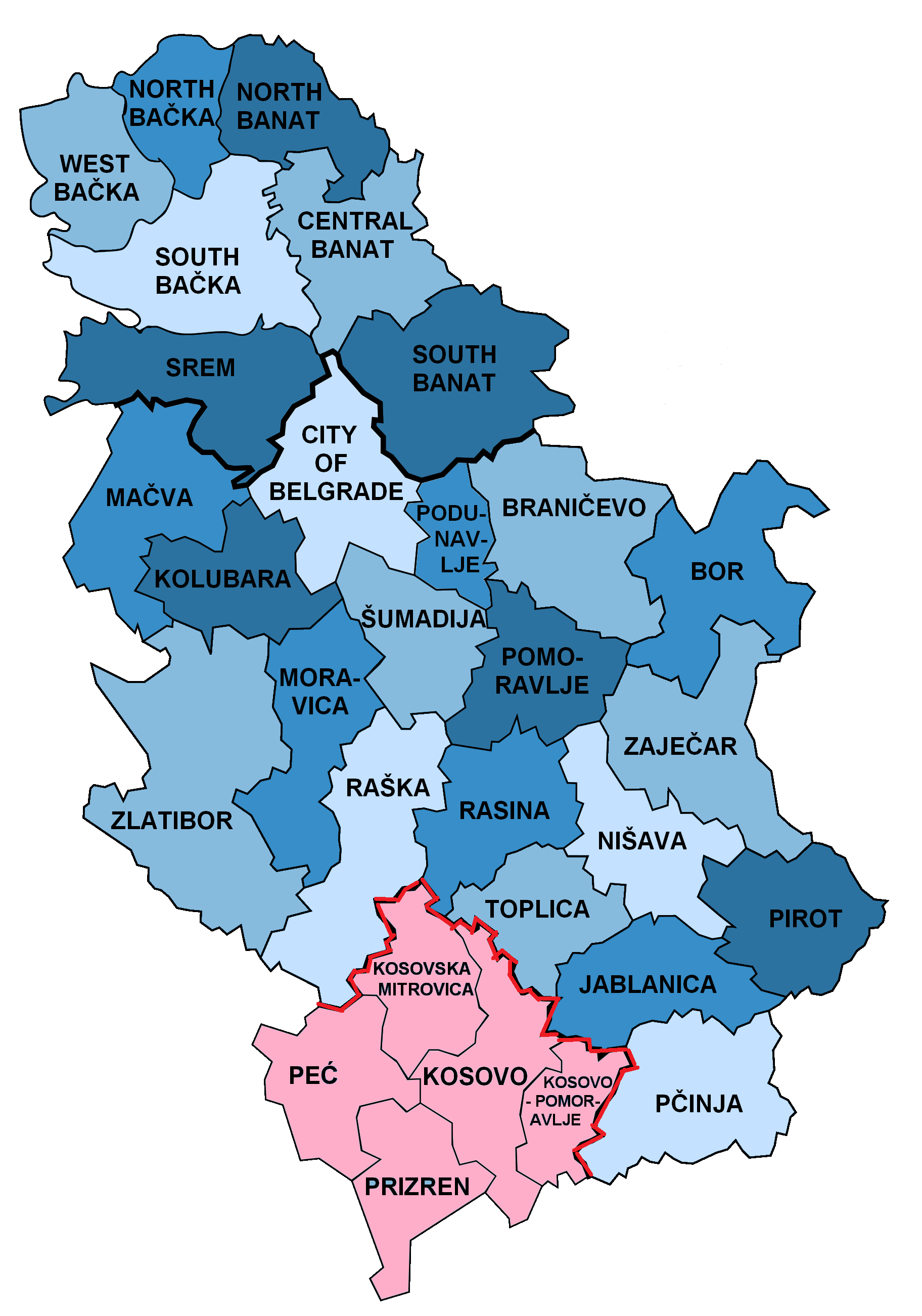
The factual accuracy of this map or the file name is disputed.
Reason: English: This version of the districts of Serbia has been uploaded and represents a consensus of the community to what should be displayed. This presentation does not represent all geopolitical views of the current situation in Kosovo and Serbia, so alternate presentation forms are available as displayed in "Other versions". Wikis are able to determine their appropriate usage, it is Commons role to provide those representations. |  |
Summary
.png)
.png)


.png)
Licensing
| Public domainPublic domainfalsefalse |
| I, the copyright holder of this work, release this work into the public domain. This applies worldwide. In some countries this may not be legally possible; if so: I grant anyone the right to use this work for any purpose, without any conditions, unless such conditions are required by law. |
Original upload log
This image is a derivative work of the following images:
- File:Disricts_of_Serbia_by_population_density.svg licensed with PD-self
- 2010-04-25T18:39:42Z Алексей Глушков 765x1060 (47381 Bytes) {{Information |Description={{en|1=Map of disricts of Serbia by population density}} {{sr|1=Карта округа Србија на густини становништва}} |Source=Own work |Author=Gajmar at [http://ru.wiki
Uploaded with derivativeFX
Captions
Add a one-line explanation of what this file represents
Items portrayed in this file
depicts
30 September 2010
File history
Click on a date/time to view the file as it appeared at that time.
| Date/Time | Thumbnail | Dimensions | User | Comment | |
|---|---|---|---|---|---|
| current | 08:02, 24 February 2022 | | 1,824 × 2,603 (445 KB) | Túrelio | Reverted to version as of 11:37, 2 October 2021 (UTC), as violation of COM:OW |
| 20:10, 14 January 2022 |  | 1,824 × 2,603 (589 KB) | TómasdeAquino2 | stable version per file name | |
| 11:37, 2 October 2021 |  | 1,824 × 2,603 (445 KB) | InNeed95 | Reverted to version as of 19:42, 29 September 2021 (UTC) /// Rv. Sock-Acc. POV-Push. / Vandlism | |
| 06:35, 30 September 2021 |  | 1,824 × 2,603 (589 KB) | Aquinasthomes1 | Reverted to version as of 03:42, 26 September 2021 (UTC) Revert Vandalism | |
| 19:42, 29 September 2021 |  | 1,824 × 2,603 (445 KB) | InNeed95 | Reverted to version as of 13:20, 6 August 2021 (UTC) /// Rv. Sock-Acc. POV-Push. | |
| 03:42, 26 September 2021 |  | 1,824 × 2,603 (589 KB) | Aquinasthomes1 | minor fix in contour | |
| 02:53, 26 September 2021 |  | 1,824 × 2,603 (458 KB) | Aquinasthomes1 | Reverted to version as of 22:39, 31 May 2015 (UTC). Per alternative image | |
| 13:20, 6 August 2021 |  | 1,824 × 2,603 (445 KB) | InNeed95 | Reverted to version as of 21:27, 31 May 2015 (UTC) Consensus. Showing the disputed status of Kosovo. (Districts in Kosovo are also shown as claimed by serbia) /// Its better to have one single map instead of many different ones. (Adding that the other maps are not in use at all compared to this one) | |
| 22:39, 31 May 2015 |  | 1,824 × 2,603 (458 KB) | Anastan | We already have that file File:Districts_of_Serbia_(Kosovo_disputed).png | |
| 21:27, 31 May 2015 |  | 1,824 × 2,603 (445 KB) | VS6507 | consensus version |
File usage
The following pages on the English Wikipedia use this file (pages on other projects are not listed):
Global file usage
The following other wikis use this file:
- Usage on bar.wikipedia.org
- Usage on ca.wikipedia.org
- Usage on cs.wikipedia.org
- Usage on el.wikipedia.org
- Usage on es.wikipedia.org
- Usage on fa.wikipedia.org
- Usage on fi.wikipedia.org
- Usage on frr.wikipedia.org
- Usage on fr.wikipedia.org
- Usage on id.wikipedia.org
- Usage on lt.wikipedia.org
- Usage on mzn.wikipedia.org
- Usage on or.wikipedia.org
- Usage on pl.wikipedia.org
- Usage on pnb.wikipedia.org
- Usage on ps.wikipedia.org
- Usage on ro.wikipedia.org
- Usage on sco.wikipedia.org
- Usage on sh.wikipedia.org
- Usage on sv.wikipedia.org
- Usage on th.wikipedia.org
- Usage on tr.wikipedia.org
- Usage on ur.wikipedia.org
- Usage on vec.wikipedia.org
- Usage on vi.wikipedia.org
Metadata
This file contains additional information, probably added from the digital camera or scanner used to create or digitize it.
If the file has been modified from its original state, some details may not fully reflect the modified file.
| Horizontal resolution | 37.8 dpc |
|---|---|
| Vertical resolution | 37.8 dpc |
| File change date and time | 18:44, 25 April 2010 |
Retrieved from "https://en.wikipedia.org/wiki/File:Districts_of_Serbia.png"