File:Enseada_de_Botafogo_e_Pão_de_Açúcar.jpg
From Wikipedia, the free encyclopedia
Size of this preview: 800 × 533 pixels. Other resolutions: 320 × 213 pixels | 640 × 427 pixels | 1,024 × 683 pixels | 1,280 × 853 pixels | 2,560 × 1,707 pixels | 4,752 × 3,168 pixels.
Original file (4,752 × 3,168 pixels, file size: 2.58 MB, MIME type: image/jpeg)
| This is a file from the Wikimedia Commons. Information from its description page there is shown below. Commons is a freely licensed media file repository. You can help. |
Summary
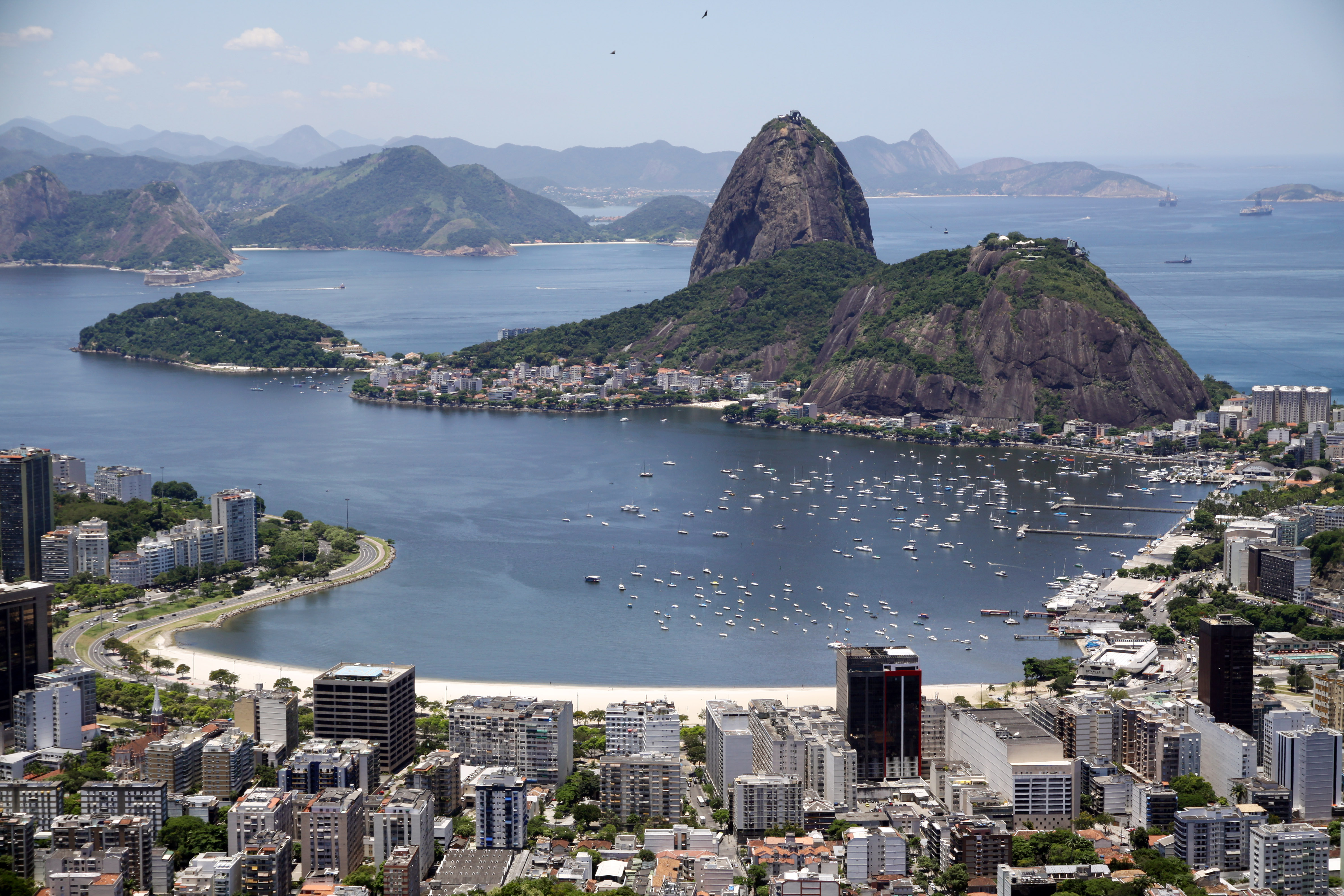
| DescriptionEnseada de Botafogo e Pão de Açúcar.jpg |
Português: Enseada de Botafogo e Pão de Açúcar vistos do Mirante de Dona Marta. |
| Date | |
| Source | Own work |
| Author | Halley Pacheco de Oliveira |
| Camera location | 22° 56′ 42.1″ S, 43° 11′ 47.05″ W | View this and other nearby images on: OpenStreetMap |
|---|
Licensing
I, the copyright holder of this work, hereby publish it under the following license:
This file is licensed under the Creative Commons Attribution-Share Alike 3.0 Unported license.
- You are free:
- to share – to copy, distribute and transmit the work
- to remix – to adapt the work
- Under the following conditions:
- attribution – You must give appropriate credit, provide a link to the license, and indicate if changes were made. You may do so in any reasonable manner, but not in any way that suggests the licensor endorses you or your use.
- share alike – If you remix, transform, or build upon the material, you must distribute your contributions under the same or compatible license as the original.
Captions
Add a one-line explanation of what this file represents
Items portrayed in this file
depicts
some value
25 January 2012
22°56'42.09580"S, 43°11'47.05451"W
File history
Click on a date/time to view the file as it appeared at that time.
| Date/Time | Thumbnail | Dimensions | User | Comment | |
|---|---|---|---|---|---|
| current | 19:41, 27 December 2012 | | 4,752 × 3,168 (2.58 MB) | Halleypo | User created page with UploadWizard |
File usage
The following pages on the English Wikipedia use this file (pages on other projects are not listed):
Global file usage
The following other wikis use this file:
- Usage on ar.wikipedia.org
- Usage on azb.wikipedia.org
- Usage on bg.wikipedia.org
- Usage on ca.wikipedia.org
- Usage on el.wikipedia.org
- Usage on el.wikivoyage.org
- Usage on es.wikipedia.org
- Usage on eu.wikipedia.org
- Usage on fa.wikipedia.org
- Usage on fr.wikipedia.org
- Usage on he.wikipedia.org
- Usage on he.wikivoyage.org
- Usage on hu.wikipedia.org
- Usage on it.wikipedia.org
- Usage on ja.wikipedia.org
- Usage on map-bms.wikipedia.org
- Usage on ml.wikipedia.org
- Usage on mn.wikipedia.org
- Usage on ms.wikipedia.org
- Usage on nl.wikipedia.org
- Usage on no.wikipedia.org
- Usage on pl.wikipedia.org
- Usage on pt.wikipedia.org
- Botafogo
- Lista de arranha-céus da cidade do Rio de Janeiro
- Wikipédia:Wiki Loves Monuments 2019/Brasil/Lista/Rio de Janeiro/Rio de Janeiro
- Wikipédia:Wiki Loves Monuments 2020/Brasil/Lista/Rio de Janeiro/Rio de Janeiro
- Wikipédia:Wiki Loves Monuments 2021/Brasil/Lista/Rio de Janeiro/Rio de Janeiro/Zona Sul
- Usuário:EPorto (WMB)/Testes/Rio de Janeiro/Rio de Janeiro
- Wikipédia:Wiki Loves Monuments 2022/Brasil/Lista/Rio de Janeiro/Rio de Janeiro/Zona Sul
- Wikipédia:Wiki Loves Monuments 2023/Brasil/Lista/Rio de Janeiro/Rio de Janeiro
- Wikipédia:Wiki Loves Monuments 2023/Brasil/Lista/Rio de Janeiro/Rio de Janeiro/Zona Sul
- Usage on sv.wikipedia.org
- Usage on tr.wikipedia.org
- Usage on uk.wikipedia.org
- Usage on vi.wikipedia.org
- Usage on www.wikidata.org
Metadata
This file contains additional information, probably added from the digital camera or scanner used to create or digitize it.
If the file has been modified from its original state, some details may not fully reflect the modified file.
| Image title | Mirante de Dona Marta |
|---|---|
| Camera manufacturer | Canon |
| Camera model | Canon EOS 50D |
| Copyright holder | Halley Pacheco de Oliveira |
| Exposure time | 1/640 sec (0.0015625) |
| F-number | f/5.6 |
| ISO speed rating | 100 |
| Date and time of data generation | 13:15, 25 January 2012 |
| Lens focal length | 42 mm |
| Latitude | 22° 56′ 42.1″ S |
| Longitude | 43° 11′ 47.05″ W |
| Altitude | 369.434 meters above sea level |
| Orientation | Normal |
| Horizontal resolution | 72 dpi |
| Vertical resolution | 72 dpi |
| Software used | Adobe Photoshop Elements 10.0 Windows |
| File change date and time | 17:34, 27 December 2012 |
| Y and C positioning | Co-sited |
| Exposure Program | Action program (biased toward fast shutter speed) |
| Exif version | 2.21 |
| Date and time of digitizing | 13:15, 25 January 2012 |
| Meaning of each component |
|
| Shutter speed | 9.375 |
| APEX aperture | 5 |
| Exposure bias | 0 |
| Metering mode | Pattern |
| Flash | Flash did not fire, compulsory flash suppression |
| DateTime subseconds | 03 |
| DateTimeOriginal subseconds | 03 |
| DateTimeDigitized subseconds | 03 |
| Supported Flashpix version | 1 |
| Color space | sRGB |
| Focal plane X resolution | 5,315.4362416107 |
| Focal plane Y resolution | 5,306.5326633166 |
| Focal plane resolution unit | inches |
| Custom image processing | Normal process |
| Exposure mode | Auto exposure |
| White balance | Auto white balance |
| Scene capture type | Standard |
| GPS time (atomic clock) | 15:15 |
| GPS date | 25 January 2012 |
| GPS tag version | 0.0.2.2 |
| Supported Flashpix version | 1 |
| Image width | 4,752 px |
| Image height | 3,168 px |
| Date metadata was last modified | 15:34, 27 December 2012 |
| Unique ID of original document | xmp.did:8C2476785C50E211BF2EF81EDC8A5218 |
| Country shown | Brazil |
| Province or state shown | Rio de Janeiro |