File:Erzgebirge_phys_map_de.png
From Wikipedia, the free encyclopedia
Size of this preview: 800 × 505 pixels. Other resolutions: 320 × 202 pixels | 640 × 404 pixels | 1,024 × 646 pixels | 1,280 × 808 pixels | 1,797 × 1,134 pixels.
Original file (1,797 × 1,134 pixels, file size: 2.33 MB, MIME type: image/png)
| This is a file from the Wikimedia Commons. Information from its description page there is shown below. Commons is a freely licensed media file repository. You can help. |
Summary
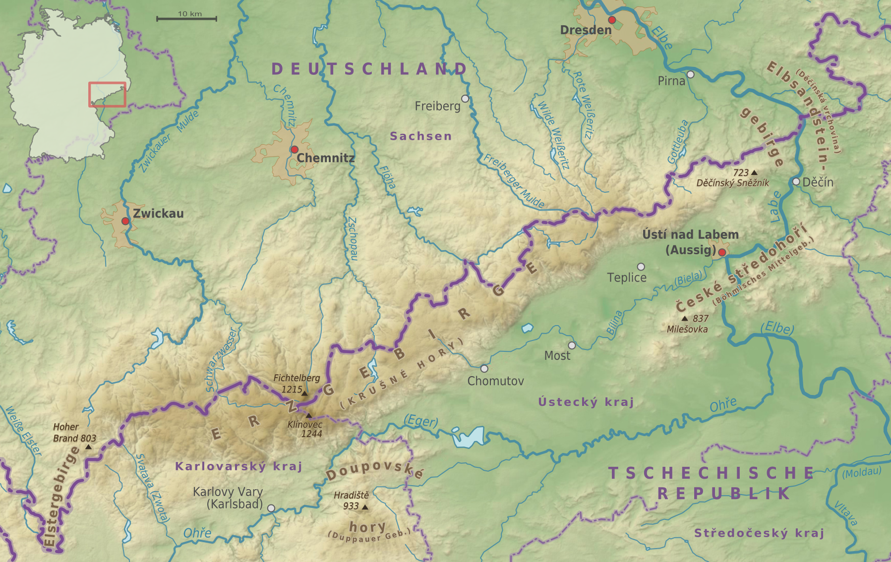
| DescriptionErzgebirge phys map de.png |
Deutsch: Erzgebirge - Physische Karte |
| Date | |
| Source |
own work, using
|
| Author | Alexrk2 |
| Permission (Reusing this file) |
All OpenStreetMap data and maps are Creative Commons "CC-BY-SA 2.0" licensed |

|
This map has been made or improved in the German Kartenwerkstatt (Map Lab). You can propose maps to improve as well.
azərbaycanca ∙ čeština ∙ Deutsch ∙ Deutsch (Sie-Form) ∙ English ∙ español ∙ français ∙ italiano ∙ latviešu ∙ magyar ∙ Nederlands ∙ Plattdüütsch ∙ polski ∙ português ∙ română ∙ sicilianu ∙ slovenščina ∙ suomi ∙ македонски ∙ русский ∙ ქართული ∙ հայերեն ∙ বাংলা ∙ ไทย ∙ +/−
|
Licensing
I, the copyright holder of this work, hereby publish it under the following license:
This file is licensed under the Creative Commons Attribution-Share Alike 3.0 Unported license.
- You are free:
- to share – to copy, distribute and transmit the work
- to remix – to adapt the work
- Under the following conditions:
- attribution – You must give appropriate credit, provide a link to the license, and indicate if changes were made. You may do so in any reasonable manner, but not in any way that suggests the licensor endorses you or your use.
- share alike – If you remix, transform, or build upon the material, you must distribute your contributions under the same or compatible license as the original.
Captions
Add a one-line explanation of what this file represents
Items portrayed in this file
depicts
December 2009
File history
Click on a date/time to view the file as it appeared at that time.
| Date/Time | Thumbnail | Dimensions | User | Comment | |
|---|---|---|---|---|---|
| current | 16:38, 21 December 2010 | | 1,797 × 1,134 (2.33 MB) | Alexrk2 | Chemnitz (Fluss) korrigiert |
| 15:46, 19 May 2010 |  | 1,797 × 1,134 (2.33 MB) | Alexrk2 | Pressnitz/Zschopau | |
| 21:27, 3 December 2009 |  | 1,797 × 1,134 (2.33 MB) | Alexrk2 | 2. Review | |
| 13:03, 3 December 2009 |  | 1,797 × 1,134 (2.32 MB) | Alexrk2 | 1. Review | |
| 21:48, 2 December 2009 |  | 1,797 × 1,134 (2.2 MB) | Alexrk2 | == Summary == == {{int:filedesc}} == {{Information |Description={{de|Erzgebirge - Physische Karte}} |Source=|Source=own work, using * VMAP0 * SRTM3 * Geonames.org * [http://www.openstreetmap.org Openstreetmap] data * File:Germany location map.svg by |
File usage
The following pages on the English Wikipedia use this file (pages on other projects are not listed):
Global file usage
The following other wikis use this file:
- Usage on ar.wikipedia.org
- Usage on bg.wikipedia.org
- Usage on bs.wikipedia.org
- Usage on cs.wikipedia.org
- Usage on de.wikipedia.org
- Usage on eo.wikipedia.org
- Usage on es.wikipedia.org
- Usage on fr.wikipedia.org
- Usage on he.wikipedia.org
- Usage on hr.wikipedia.org
- Usage on is.wikipedia.org
- Usage on it.wikipedia.org
- Usage on ja.wikipedia.org
- Usage on ko.wikipedia.org
- Usage on lt.wikipedia.org
- Usage on mk.wikipedia.org
- Usage on nl.wikipedia.org
- Usage on no.wikipedia.org
- Usage on pl.wikipedia.org
- Usage on ro.wikipedia.org
- Usage on sw.wikipedia.org
- Usage on vi.wikipedia.org
- Usage on www.wikidata.org
Retrieved from "https://en.wikipedia.org/wiki/File:Erzgebirge_phys_map_de.png"