File:Map_of_Sunda_and_Sahul.png
From Wikipedia, the free encyclopedia
Size of this preview: 661 × 599 pixels. Other resolutions: 265 × 240 pixels | 530 × 480 pixels | 847 × 768 pixels | 1,111 × 1,007 pixels.
Original file (1,111 × 1,007 pixels, file size: 208 KB, MIME type: image/png)
| This is a file from the Wikimedia Commons. Information from its description page there is shown below. Commons is a freely licensed media file repository. You can help. |

|
File:Map of Sunda and Sahul.svg is a vector version of this file. It should be used in place of this PNG file when not inferior.
File:Map of Sunda and Sahul.png → File:Map of Sunda and Sahul.svg
For more information, see Help:SVG.
|
 |
| DescriptionMap of Sunda and Sahul.png |
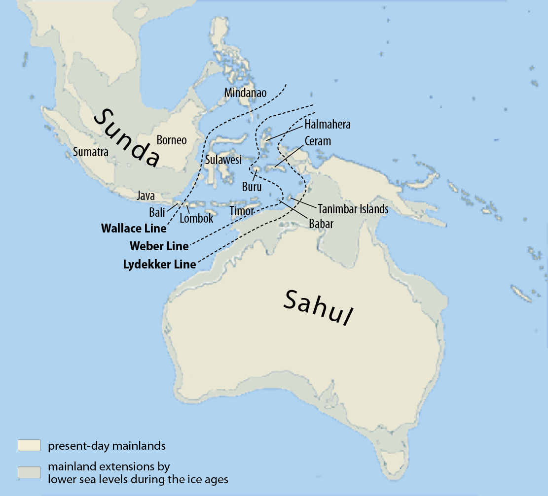
Deutsch: Karte von Sunda und Sahul sowie der Wallace-Linie, der Lydekker-Linie und der Weber-Linie.
Français : Carte de Sunda, de Sahul et de la ligne Wallace, de la ligne Lydekker et de la ligne Weber
Español: Mapa de Sunda y Sahul con la línea de Wallace, la línea de Lydekker y la línea de Weber.
|
| Date | |
| Source | Self made, using this map for the background |
| Author | Maximilian Dörrbecker (Chumwa) |
| Permission (Reusing this file) |
I, the copyright holder of this work, hereby publish it under the following license: This file is licensed under the Creative Commons Attribution-Share Alike 3.0 Unported license.
Sie dürfen das Bild zu den folgenden Bedingungen nutzen:
|
| Other versions |
|


Captions
Indonesia
October 2007
File history
Click on a date/time to view the file as it appeared at that time.
| Date/Time | Thumbnail | Dimensions | User | Comment | |
|---|---|---|---|---|---|
| current | 08:07, 5 March 2017 | | 1,111 × 1,007 (208 KB) | Chumwa | corr |
| 06:46, 25 July 2009 |  | 1,111 × 1,007 (269 KB) | Chumwa | Inseln -> Islands | |
| 06:13, 25 July 2009 |  | 1,111 × 1,007 (268 KB) | Chumwa | {{Information |Description= {{ de }}Karte von Sunda und Sahul sowie der Wallace-Linie, der Lydekker-Linie und der Weber-Linie. * Als Sahul wird die zusammenhängende Landmasse bezeichnet, die während der letzten Eiszeit aus Australien, der nordöstlich d |
File usage
The following pages on the English Wikipedia use this file (pages on other projects are not listed):
- Canis lupus dingo
- Denisovan
- Dingo
- List of butterflies of the Philippines
- List of lost lands
- Models of migration to the Philippines
- New Guinea singing dog
- Red-naped trogon
- User:Cruickshanks/Sandbox
- User:Obsidian Soul/sandbox
- Wikipedia:Categories for discussion/Log/2015 June 26
- Wikipedia:Reference desk/Archives/Science/2011 May 15
Global file usage
The following other wikis use this file:
- Usage on ar.wikipedia.org
- Usage on ast.wikipedia.org
- Usage on be.wikipedia.org
- Usage on bg.wikipedia.org
- Usage on bn.wikipedia.org
- Usage on ca.wikipedia.org
- Usage on cs.wikipedia.org
- Usage on de.wikipedia.org
- Usage on eo.wikipedia.org
- Usage on es.wikipedia.org
- Usage on fa.wikipedia.org
- Usage on fi.wikipedia.org
- Usage on fr.wikipedia.org
- Usage on gl.wikipedia.org
- Usage on he.wikipedia.org
- Usage on hi.wikipedia.org
- Usage on hr.wikipedia.org
- Usage on hu.wikipedia.org
View more global usage of this file.
Metadata
This file contains additional information, probably added from the digital camera or scanner used to create or digitize it.
If the file has been modified from its original state, some details may not fully reflect the modified file.
| Horizontal resolution | 39.37 dpc |
|---|---|
| Vertical resolution | 39.37 dpc |
| Software used |
Retrieved from "https://en.wikipedia.org/wiki/File:Map_of_Sunda_and_Sahul.png"