File:SanDiegoSoutheastMap.gif
From Wikipedia, the free encyclopedia
No higher resolution available.
SanDiegoSoutheastMap.gif (500 × 500 pixels, file size: 60 KB, MIME type: image/gif)
| This is a file from the Wikimedia Commons. Information from its description page there is shown below. Commons is a freely licensed media file repository. You can help. |
Summary
| DescriptionSanDiegoSoutheastMap.gif |
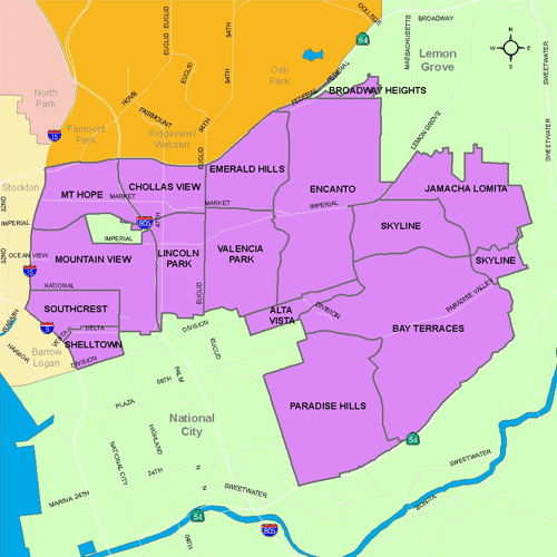
English: Map of Southeast San Diego |
| Source | City of San Diego website, http://www.sandiego.gov/neighborhoodmaps/central.shtml |
| Author | City of San Diego |
| Permission (Reusing this file) |
Image is in the public domain, as indicated by the disclaimer of the website of the City of San Diego, found here: http://www.sandiego.gov/directories/disclaimer.shtml An excerpt: Unless a copyright is indicated, information on the City of San Diego Web site is in the public domain and may be reproduced, published or otherwise used with the City of San Diego's permission. We request only that the City of San Diego be cited as the source of the information and that any photo credits, graphics or byline be similarly credited to the photographer, author or City of San Diego, as appropriate. |
Licensing
| Public domainPublic domainfalsefalse |
This media file is in the public domain in the United States. This applies to U.S. works where the copyright has expired, often because its first publication occurred prior to January 1, 1929, and if not then due to lack of notice or renewal. See this page for further explanation.
|
 | |
 |
This image might not be in the public domain outside of the United States; this especially applies in the countries and areas that do not apply the rule of the shorter term for US works, such as Canada, Mainland China (not Hong Kong or Macao), Germany, Mexico, and Switzerland. The creator and year of publication are essential information and must be provided. See Wikipedia:Public domain and Wikipedia:Copyrights for more details.
|
Original upload log
Transferred from en.wikipedia to Commons by Quadell using CommonsHelper.
The original description page was here. All following user names refer to en.wikipedia.
- 2007-09-08 18:19 Quaoar 500×500× (61715 bytes) City of San Diego website, http://www.sandiego.gov/neighborhoods-map/southeast.shtml == Licensing == Image is in the public domain, as indicated by the disclaimer of the website of the City of San Diego, found here: http://www.sandiego.gov/d
- 2006-08-26 05:14 Mappychris 350×260× (34267 bytes) City of San Diego website, http://www.sandiego.gov/neighborhoods-map/southeast.shtml == Licensing == Image is in the public domain, as indicated by the disclaimer of the website of the City of San Diego, found here: http://www.sandiego.gov/d
File history
Click on a date/time to view the file as it appeared at that time.
| Date/Time | Thumbnail | Dimensions | User | Comment | |
|---|---|---|---|---|---|
| current | 13:59, 12 September 2011 | | 500 × 500 (60 KB) | File Upload Bot (Magnus Manske) | {{BotMoveToCommons|en.wikipedia|year={{subst:CURRENTYEAR}}|month={{subst:CURRENTMONTHNAME}}|day={{subst:CURRENTDAY}}}} {{Information |Description={{en|City of San Diego website, http://www.sandiego.gov/neighborhoods-map/southeast.shtml Image is in the pu |
File usage
The following pages on the English Wikipedia use this file (pages on other projects are not listed):
- Alta Vista, San Diego
- Bay Terraces, San Diego
- Broadway Heights, San Diego
- Chollas View, San Diego
- Emerald Hills, San Diego
- Encanto, San Diego
- Jamacha, San Diego
- Lincoln Park, San Diego
- Lomita, San Diego
- Mount Hope, San Diego
- Mountain View, San Diego
- Oak Park, San Diego
- Paradise Hills, San Diego
- Shelltown, San Diego
- Skyline, San Diego
- Southcrest, San Diego
- Southeast San Diego
- Valencia Park, San Diego
Global file usage
The following other wikis use this file:
- Usage on es.wikipedia.org
- Usage on www.wikidata.org
Retrieved from "https://en.wikipedia.org/wiki/File:SanDiegoSoutheastMap.gif"