File:Zonal_Councils_mk.svg
From Wikipedia, the free encyclopedia

Size of this PNG preview of this SVG file: 511 × 599 pixels. Other resolutions: 205 × 240 pixels | 410 × 480 pixels | 655 × 768 pixels | 874 × 1,024 pixels | 1,748 × 2,048 pixels | 1,594 × 1,868 pixels.
Original file (SVG file, nominally 1,594 × 1,868 pixels, file size: 248 KB)
| This is a file from the Wikimedia Commons. Information from its description page there is shown below. Commons is a freely licensed media file repository. You can help. |
Summary
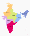
| DescriptionZonal Councils mk.svg |
Македонски: Карта на подрачните совети во Индија.
English: Map of the zonal councils of India, in Macedonian. |
| Date | |
| Source | File:Zonal Councils.svg |
| Author |
original by Filpro derivative by B. Jankuloski |
| Other versions |
[edit]
|


Licensing
This file is licensed under the Creative Commons Attribution-Share Alike 4.0 International license.
- You are free:
- to share – to copy, distribute and transmit the work
- to remix – to adapt the work
- Under the following conditions:
- attribution – You must give appropriate credit, provide a link to the license, and indicate if changes were made. You may do so in any reasonable manner, but not in any way that suggests the licensor endorses you or your use.
- share alike – If you remix, transform, or build upon the material, you must distribute your contributions under the same or compatible license as the original.
Captions
Add a one-line explanation of what this file represents
Items portrayed in this file
depicts
27 September 2017
File history
Click on a date/time to view the file as it appeared at that time.
| Date/Time | Thumbnail | Dimensions | User | Comment | |
|---|---|---|---|---|---|
| current | 15:36, 26 April 2018 | | 1,594 × 1,868 (248 KB) | फ़िलप्रो | Delhi is actually in the Northern Zonal Council |
| 04:47, 27 September 2017 |  | 1,594 × 1,868 (251 KB) | Bjankuloski06 | User created page with UploadWizard |
File usage
No pages on the English Wikipedia use this file (pages on other projects are not listed).
Metadata
This file contains additional information, probably added from the digital camera or scanner used to create or digitize it.
If the file has been modified from its original state, some details may not fully reflect the modified file.
| Width | 1594px |
|---|---|
| Height | 1868px |
Retrieved from "https://en.wikipedia.org/wiki/File:Zonal_Councils_mk.svg"