Hughes Airport (California)
US private airport operating 1940–1985 / From Wikipedia, the free encyclopedia
Dear Wikiwand AI, let's keep it short by simply answering these key questions:
Can you list the top facts and stats about Hughes Airport (California)?
Summarize this article for a 10 year old
SHOW ALL QUESTIONS
The Hughes Airport (IATA: CVR) was a private airport owned by Howard Hughes for the Hughes Aircraft Company. It was located just north of the Westchester bluffs and district of Los Angeles, California, from 1940 until its closure in 1985. It was directly south of and along Jefferson Boulevard and Ballona Creek, the location of the present-day neighborhood of Playa Vista.
Quick Facts Summary, Airport type ...
Hughes Airport | |||||||||||
|---|---|---|---|---|---|---|---|---|---|---|---|
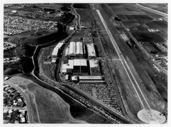 “Aerial photograph of Hughes Airport, Culver City, California, circa early 1960s” | |||||||||||
| Summary | |||||||||||
| Airport type | Private | ||||||||||
| Owner | Howard Hughes | ||||||||||
| Operator | Hughes Aircraft Company | ||||||||||
| Location | current day Playa Vista, Los Angeles | ||||||||||
| Opened | 1943 (1943) | ||||||||||
| Closed | 1986 (1986) | ||||||||||
| Time zone | PST (-8:00) | ||||||||||
| • Summer (DST) | PDT (-7:00) | ||||||||||
| Elevation AMSL | 75 ft / 23 m | ||||||||||
| Coordinates | 33.975000°N 118.417000°W / 33.975000; -118.417000 | ||||||||||
| Maps | |||||||||||
 The neighborhood in which the majority of the Hughes Airport used to be; location of the runway is just south of where current day Jefferson Blvd runs | |||||||||||
 Hughes Airport Location of the former Hughes Airport in Western Los Angeles | |||||||||||
| Runways | |||||||||||
| |||||||||||
Close