User:Gazamp/Safekeeping
From Wikipedia, the free encyclopedia
The Andes (/ˈændiːz/ AN-deez), Andes Mountains or Andean Mountain Range (Spanish: Cordillera de los Andes; Quechua: Anti) are the longest continental mountain range in the world, forming a continuous highland along the western edge of South America. The range is 8,900 km (5,530 mi) long and 200 to 700 km (124 to 435 mi) wide (widest between 18°S and 20°S latitude) and has an average height of about 4,000 m (13,123 ft). The Andes extend from north to south through seven South American countries: Venezuela, Colombia, Ecuador, Peru, Bolivia, Chile and Argentina.
| {{{1}}} |
|2=
|2=

Along their length, the Andes are split into several ranges, separated by intermediate depressions. The Andes are the location of several high plateaus—some of which host major cities such as Quito, Bogotá, Cali, Arequipa, Medellín, Bucaramanga, Sucre, Mérida, El Alto and La Paz. The Altiplano Plateau is the world's second-highest after the Tibetan Plateau. These ranges are in turn grouped into three major divisions based on climate: the Tropical Andes, the Dry Andes, and the Wet Andes. (Full article...)
Selected general articles
 Image 1
 Galán viewed from space
Cerro Galán is a caldera in the Catamarca Province of Argentina. It is one of the largest exposed calderas in the world and forms part of the Central Volcanic Zone of the Andes, one of the three volcanic belts found in South America. One of several major caldera systems in the Central Volcanic Zone, the mountain is grouped into the Altiplano–Puna volcanic complex.
Volcanic activity at Galán is the indirect consequence of the subduction of the Nazca Plate beneath the South America Plate, and involves the infiltration of melts into the crust and the formation of secondary magmas which after storage in the crust give rise to the dacitic to rhyodacitic rocks erupted by the volcano. (Full article...)- Image 2
 Pico Bonpland as seen from the Pico Humboldt
Pico Bonpland is Venezuela's third highest peak, at 4,883 metres above sea level. It is located in the Sierra Nevada de Merida, in the Venezuelan Andes of (Mérida State). The peak with its sister peak Pico Humboldt, and the surrounding páramos are protected by the Sierra Nevada National Park. The name of the peak is in honor of Aimé Bonpland, although he never visited the Venezuelan Andes.
The glaciers located in the Bonpland were the result from Merida glaciation in the Pleistocene. By 2011 they had all disappeared. (Full article...) - Image 3

Map showing Iru Phutunqu on the border of Bolivia and Chile, south of the Umani
Iruputuncu (possibly from Aymara iru spiny Peruvian feather grass, phutunqu a small vessel or a hole, pit, crater) is a mountain in the Andes in the Cordillera Occidental on the border of Bolivia and Chile. The Chilean side is in the Tarapacá Region, and the Bolivian side is in the Potosí Department, Daniel Campos Province, Llica Municipality. Iruputuncu is southeast of Mount Candelaria, west of the Salar de Uyuni salt flat and south of the Umani. It is about 4,200 m (13,780 ft) high. (Full article...) - Image 4

The guanaco (/ɡwɑːˈnɑːkoʊ/ ghwuah-NAH-koh; Lama guanicoe) is a camelid native to South America, closely related to the llama. Guanacos are one of two wild South American camelids; the other species is the vicuña, which lives at higher elevations. (Full article...) - Image 5
 The Cerro Bayo volcanic complex lies along the Chile-Argentina border east of the Salar de Gorbea, the light-colored area at the left-center portion of this NASA Landsat image. A young well-preserved crater can be seen NE of an older snow-covered center (bottom-center). A younger northern center along the national border has a well-preserved 400-m-wide crater.
Cerro Bayo is a complex volcano on the northern part border between Argentina and Chile. It consists of four overlapping stratovolcanoes along a north–south line. The main volcano face is located on the Argentine side, thought the summit of the complex is just west of the border, in Chile. The volcano is about 800,000 years old, but it is associated with ongoing ground uplift encompassing also the more northerly Lastarria and Cordón del Azufre volcanoes. The 5,401-metre (17,720 ft) high summit is the source of two viscous dacitic lava flows with prominent levees that traveled to the north.
Elemental sulfur can be found at Bayo, both in the form of high-grade massive deposits and as extinct fumarole chimneys. The volcano formed in three separate phases that produced lava flows. One is dated to 1.6±0.4 million years ago. The volcano can bear snow in winter. The youngest dated rocks are about 23,000 years old; in 2007 a steam eruption were observed by researchers investigating nearby salt pans such as Salar Ignorado. (Full article...) - Image 6
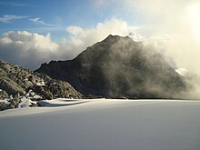
 Pico Aguja (5.000 m), seen from North.
El Cocuy National Park is a national park located in the Andes Mountains within the nation of Colombia. Its official name is Parque Nacional Natural El Cocuy. (Full article...) - Image 7
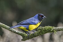 Buthraupis montana cucullata, Colombia
The hooded mountain tanager (Buthraupis montana) is a species of bird in the tanager family Thraupidae. It is the only member of the genus Buthraupis. This yellow, blue and black tanager is found in forest, woodland and shrub in the Andean highlands of Bolivia, Colombia, Ecuador, Peru, and Venezuela. At 23 centimetres (9.1 in) and 85 grams (3.0 oz), it is one of the largest tanagers (second in weight only to the white-capped tanager). (Full article...) - Image 8

Olca is a stratovolcano on the border of Chile and Bolivia. It lies in the middle of a 15 km long ridge composed of several stratovolcanos. Cerro Minchincha lies to the west and Paruma to the east. It is also close to the pre-Holocene Cerro Paruma. It is andesitic and dacitic in composition, with lava flows extending several kilometres north of the peak. The only activity from the ridge during historical times was a flank eruption from 1865 to 1867. The exact source of this eruption is unclear. (Full article...) - Image 9
 Pico Humboldt in 2008
Pico Humboldt is Venezuela's second highest peak, at 4,925 metres above sea level. It is located in the Sierra Nevada de Merida, in the Venezuelan Andes of (Mérida State). The peak, its sister peak Pico Bonpland, and the surrounding páramos are protected by the Sierra Nevada National Park. The mountain is named after German explorer and naturalist Alexander von Humboldt. (Full article...) - Image 10
 The upper right part of the NASA Space Shuttle image shows the eroded volcanic complex Nevado Anallajsi.
Nevado Anallajsi is a stratovolcano in Bolivia. The date of its last eruption is unknown, but its youngest lava flows appear to have erupted from a vent on the north flank of the mountain. The main composition of the volcano is andesitic and dacitic. It overlies a plateau which is composed of ignimbrite. The volcano covers an area of 368.8 square kilometres (142.4 sq mi) and is 10.2 mya old based on its erosion state, while other estimates indicate an age of 2.6 mya. (Full article...) - Image 11

The royal cinclodes (Cinclodes aricomae) is a Critically Endangered passerine bird in the Furnariinae subfamily of the ovenbird family Furnariidae. It is found in Bolivia and Peru. (Full article...) - Image 12Irruputuncu is a volcano in the commune of Pica, Tamarugal Province, Tarapacá Region, Chile, as well as San Pedro de Quemes Municipality, Nor Lípez Province, Potosí Department, Bolivia. The mountain's summit is 5,163 m (16,939 ft) high and has two summit craters—the southernmost 200 m (660 ft)-wide one has active fumaroles. The volcano also features lava flows, block and ash flows and several lava domes. The volcano is part of the Andean Central Volcanic Zone (CVZ).
The volcano has been active during the Pleistocene and Holocene, with major eruptions occurring 258.2 ± 48.8 ka ago, between 55.9 ka and 140 ka ago and 1570 ± 900 BP (380 ± 900 AD), which were accompanied by the formation of ignimbrites. Historical volcanic activity is less clear; an eruption in 1989 is considered unconfirmed. Plumes linked to phreatomagmatic eruptive activity were observed on 26 November 1995 and 1 September 2003. Seismic activity is also observed on Irruputuncu, and ongoing fumarolic activity releasing 21–50 t/d (0.24–0.57 long ton/ks) of sulfur dioxide has left sulfur deposits in the active crater. (Full article...) - Image 13
 Monte Fitz Roy in 2013
Monte Fitz Roy (also known as Cerro Chaltén, Cerro Fitz Roy, or simply Mount Fitz Roy) is a mountain in Patagonia, on the border between Argentina and Chile. It is located in the Southern Patagonian Ice Field, near El Chaltén village and Viedma Lake. It was first climbed in 1952 by French alpinists Lionel Terray and Guido Magnone. (Full article...) - Image 14
 Tres Cruces from Ojos del Salado to the east. The higher south summit is on the left, the central summit on the right.
Nevado Tres Cruces is a massif of volcanic origin in the Andes Mountains on the border of Argentina and Chile. It has two main summits, Tres Cruces Sur at 6,748 metres (22,139 ft) and Tres Cruces Centro at 6,629 m (21,749 ft) and a third minor summit, Tres Cruces Norte 6,030 m (19,780 ft). Tres Cruces Sur is the sixth highest mountain in the Andes.
The volcano has an extended history of activity, going back at least 1.5 million years. A number of lava domes surround the complex and a number of craters lie on its summits. The main volcano is of rhyodacitic composition and has generated two major ignimbritic eruptions, one 1.5 million years ago and a second 67,000 years ago. The last eruption was 28,000 years ago, but the volcano is a candidate source for a Holocene eruption and could erupt again in the future. (Full article...) - Image 15Wayna Potosí (Aymara and Quechua wayna young, Hispanicized spelling Huayna Potosí) is a mountain in the Andes of Bolivia, about 4,969 metres (16,302 ft) high. It is located in the Oruro Department, Sajama Province, Turku Municipality, Turku Canton, northwest of Turku (Turco). The Turku River originates near the mountain. It is a left tributary of the Lauca River. (Full article...)
- Image 16
 Pico La Concha as seen from Mérida.
Pico La Concha is a mountain in the Andes of Venezuela. It has a height of 4,922 metres. (Full article...) - Image 17
 View of the range with Yerupajá in the center
Huayhuash (possibly from Quechua waywash, weasel, or waywashi, squirrel) is a mountain range within the Andes of Peru, in the boundaries of the regions of Ancash, Lima and Huánuco. Since 2002 it is protected within the Cordillera Huayhuash Reserved Zone. (Full article...) - Image 18
 Lanín as seen from Mamuil Malal Pass
Lanín is an ice-clad, cone-shaped stratovolcano on the border of Argentina and Chile. It forms part of two national parks: Lanín in Argentina and Villarrica in Chile. As a part of the flag and anthem of the Argentine province of Neuquén, it serves as a symbol for the region. Although the date of its last eruption is not known, it is estimated to have occurred within the last 10,000 years. Following the 1906 Valparaíso earthquake a local newspaper reported the volcano to have erupted, but a work published in 1917 by Karl Sapper disputed this.
The ascent is regulated by the management of Argentine National Parks and the Argentine National Gendarmerie and is technically relatively simple but has a much higher level of exposure than the neighbouring volcanoes. The nearest towns, usually employed as a base for climbers, are Pucón in Chile and Junín de los Andes in Argentina. (Full article...) - Image 19

A map of the endorheic river basins that characterize the altiplano. In the north is Lake Titicaca and the Desaguadero River system; in the south is the Salar de Uyuni salt flat. The non-endorheic altiplano extends southward into Argentina and Chile.
The Altiplano (Spanish for "high plain"), Collao (Quechua and Aymara: Qullaw, meaning "place of the Qulla") or Andean Plateau, in west-central South America, is the most extensive high plateau on Earth outside Tibet. The plateau is located at the latitude of the widest part of the north–south-trending Andes. The bulk of the Altiplano lies in Bolivia, but its northern parts lie in Peru, and its southwestern fringes lie in Chile.
There are on the plateau several cities in each of these three nations, including El Alto, La Paz, Oruro, and Puno. The northeastern part of the Altiplano is more humid than the southwestern part, which has several salares (salt flats), due to its aridity. At the Bolivia–Peru border lies Lake Titicaca, the largest lake in South America. Farther south, in Bolivia, there was until recently a lake, Lake Poopó, but by December 2015 it had completely dried up, and was declared defunct. It is unclear whether that lake, which had been the second-largest in Bolivia, can be restored. (Full article...) - Image 20
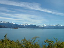 San Valentin as seen from the shore of Lake General Carrera
Monte San Valentin, also known as Monte San Clemente, is the highest mountain in Chilean Patagonia and the highest mountain south of 37°S outside Antarctica. It stands at the north end of the North Patagonian Icefield.
Monte San Valentin can be climbed from Lago Leones, to the south east, or from Laguna San Rafael, to the west. The ascent is long and is particularly subject to bad weather. (Full article...) - Image 21
 Imbabura, with corn fields in the foreground.
Imbabura is an inactive stratovolcano in northern Ecuador. Although it has not erupted for about 7,500 years, it is not thought to be extinct. Imbabura is intermittently capped with snow and has no permanent glaciers.
Covered in volcanic ash, the slopes of Imbabura are especially fertile. In addition to cloud forests, which are found across the northern Andes to an altitude of 3000 m, the land around Imbabura is extensively farmed. Maize, sugarcane, and beans are all staple crops of the region. Cattle are also an important commodity, and much of the land on and around Imbabura, especially the high-altitude meadows above the tree line, is used for grazing. (Full article...) - Image 22
 Sierra de La Culata on snowy season
The Sierra de La Culata is a mountain range in the largest massif in Venezuela, the Cordillera de Mérida, which in turn is part of the northern extent of the Cordillera de los Andes (Andes Mountains). The Sierra la Culata includes some of the highest peaks in Venezuela, such as Pico Piedras Blancas, Pico Pan de Azúcar, and Collado del Cóndor.
It is located between the states of Mérida and Trujillo. Most of the lagoons are a result of the Mérida glaciation. (Full article...) - Image 23
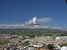 Galeras in December 2005
Galeras (Urcunina among the 16th-century indigenous people) is an Andean stratovolcano in the Colombian department of Nariño, near the departmental capital Pasto. Its summit rises 4,276 metres (14,029 ft) above sea level. It has erupted frequently since the Spanish conquest, with its first historical eruption being recorded on December 7, 1580. A 1993 eruption killed nine people, including six scientists who had descended into the volcano's crater to sample gases and take gravity measurements in an attempt to be able to predict future eruptions. It is currently the most active volcano in Colombia. (Full article...) - Image 24Parinacota, K'isi K'isini, Pomerape, Laram Q'awa, Patilla Pata and Sajama (l-r) as seen from NASA space shuttle
Laram Q'awa (Aymara larama blue, q'awa little river, ditch, crevice, fissure, gap in the earth, "blue brook" or "blue ravine", Hispanicized spellings Laram Khaua, Larancagua) is a 5,182-metre-high (17,001 ft) mountain in the Andes. According to the Bolivian IGM map 1:50,000 'Nevados Payachata Hoja 5739-I' it is situated on Bolivian terrain in the La Paz Department, Pacajes Province (Charaña Municipality), at the border with Chile. It lies north-west of the mountains Kunturiri, Phaq'u Q'awa and another mountain on the border named Laram Q'awa (Laram Khaua). One of three different rivers of this area called Kunturiri (Condoriri) originates north-east of the mountain near Phaq'u Q'awa. It flows in a bow along the northern slopes of Laram Q'awa towards Chile. (Full article...) - Image 25
 South face of Rasac, July 2010
Rasac (possibly Quechua for toad) is a mountain in the Huayhuash mountain range in west central Peru, part of the Andes. It has a summit elevation of 6,017 metres (19,741 ft), although other sources cite a height of 6,040 metres (19,816 ft). Rasac is a long, relatively squat mountain on the western edge of the Huayhuash range, across the glacier from the tallest peak in the range, Yerupajá. Although it is a 6,000 metre mountain, Rasac's broad profile is dwarfed by Yerupajá. (Full article...)


_Caldas.jpg)


Did you know...
- ... that the 1930s Polish Andean expeditions have been credited with several first ascents and the tracing of a new route to the summit of Aconcagua, the Andes' highest peak?
Need help?
Do you have a question about Andes that you can't find the answer to?
Consider asking it at the Wikipedia reference desk.
Selected images
 Image 1Pico Humboldt at sunset (from Andes)

 Image 4Bolivian Andes (from Andes)
 Image 5A male Andean cock-of-the-rock, a species found in humid Andean forests and the national bird of Peru (from Andes)


 Image 14Aerial view of Valle Carbajal in the Tierra del Fuego. The Andes range is about 200 km (124 mi) wide throughout its length, except in the Bolivian flexure where it is about 640 kilometres (398 mi) wide. (from Andes)


 Image 19Central Andes (from Andes)
 Image 20Irrigating land in the Peruvian Andes (from Andes)

 Image 23Peruvian farmers sowing maize and beans (from Andes)


.jpg)


.jpg)


–Valle_Carbajal_01.jpg)


.jpg)

Subcategories

- Select [►] to view subcategories
Associated Wikimedia
The following Wikimedia Foundation sister projects provide more on this subject:
-
 Commons
Free media repository -
 Wikibooks
Free textbooks and manuals -
 Wikidata
Free knowledge base -
 Wikinews
Free-content news -
 Wikiquote
Collection of quotations -
 Wikisource
Free-content library -
 Wikiversity
Free learning tools -
 Wiktionary
Dictionary and thesaurus
- What are portals?
- List of portals
-->