User:Yerevantsi/Maps
From Wikipedia, the free encyclopedia
- Armenian people, language, history and politics
 A map showing the distribution of the Armenians in early 17th century
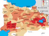 The percentage of Armenians in the eastern parts of the Ottoman Empire in 1870s
 The distribution of Armenians in early 17th century within the current borders of Turkey
 Historical and modern distribution of Armenians
 The modern concept of the United Armenia according to the ARF
 Armenia, divided between the Russian and Ottoman empires
 The location of the 1904 Sasun uprising (in orange) and the Bitlis Vilayet (in yellow).
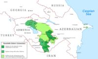
 Ethnic map of Nakhichevan in 1886-1890
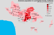 Armenians in Los Angeles County in 2000 by ZIP code
 Caucasus Front of the World War I in September 1917
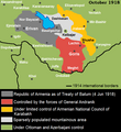 South Caucasus in October 1918
 The Republic of Mountainous Armenia, 1921
 Electoral districts of Armenia


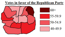

 2018 Armenian parliamentary election: Percentage of votes won by Pashinyan's My Step Alliance by electoral district

.png)


.png)

.png)


- other ethnographic, linguistic, religious and political maps


 Ethnic Russian population in the Russian Federation, %
 Percentage of followers of the Russian Orthodox Church
 Percetage of renamed place names in Turkey (1916-1980)
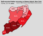 Percentages of people who self-identified as Italian during the 2000 US Census in Staten Island, New York
 Tats in Azerbaijan in 1886-1890
 Arab Christians in Syria, Jordan, Lebanon, Israel, Western Bank, Gaza strip and Egypt.
 Azerbaijanis in Georgia by districts, 2002
 Map of Greater Ukraine
 Ethnographic map of Azerbaijan, 2003
 The distribution of Lezgin people in Dagestan (Russia) and Azerbaijan in 2003
 Ethno-linguistic map of Ukraine
 The settlement area of the Meskhetian Turks in Georgian SSR in 1926


