Fichier:Map_Bih_entities.png
De Wikipedia, l'encyclopédie encyclopedia
Taille de cet aperçu : 633 × 599 pixels. Autres résolutions : 254 × 240 pixels | 507 × 480 pixels | 811 × 768 pixels | 1 103 × 1 044 pixels.
Fichier d’origine (1 103 × 1 044 pixels, taille du fichier : 67 kio, type MIME : image/png)
Ce fichier et sa description proviennent de Wikimedia Commons.
Description
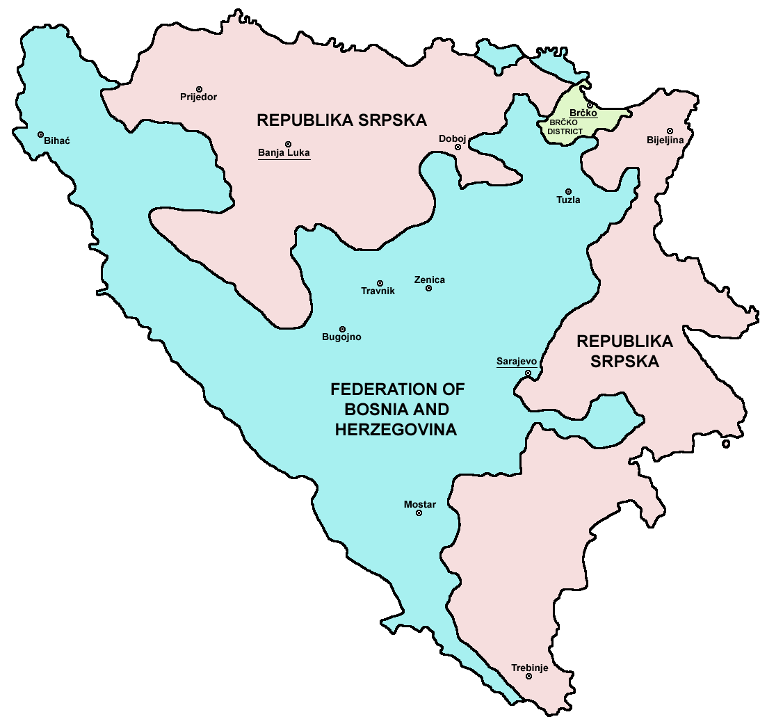
| DescriptionMap Bih entities.png |
Srpskohrvatski / српскохрватски: Federacija Bosne i Hercegovine, Republika Srpska i Distrikt Brčko / Федерација Босне и Херцеговине, Република Српска и Дистрикт Брчко. |
| Date | |
| Source | en:Image:M_bih03.png |
| Auteur | User:PANONIAN |
| Autres versions |
[modifier]
|


.png)


References
- Slobodan Radovanović, Geografski atlas, Magic Map, Smederevska Palanka, 2001.
- Geografski atlas, Intersistem kartografija, Beograd, 2004.
- http://www.mapsofworld.com/bosnia/maps/bosnia-herzegovina-map.jpg
- http://www.slobodanjovanovic.org/wp-content/uploads/2009/12/bosna-kantoni1.jpg
- http://www.thomasgraz.net/glass/map-BIH.gif
- http://aceproject.org/ero-en/regions/europe/BA/doc1.jpg/image
- United States Department of State
- http://www.visitbosnia.org/bih/images/stories/o_bih/drzavno_uredjenje/entiteti.jpg[lien mort]
- http://www.conflictgeographies.org/uploads/2/6/1/8/2618869/8958714.jpg?490 copie d'archive sur Wayback Machine
- http://vozi.org/images/stories/broj%20registrovanih%20vozila%202010.godina.png
- http://www.ohr.int/ohr-offices/brcko/images/map-brcko-district.jpg
- http://www.ohr.int/ohr-offices/brcko/images/mapa%20BD.JPG
- http://www.conflictgeographies.org/uploads/2/6/1/8/2618869/388168.jpg?490 copie d'archive sur Wayback Machine
- http://world-gazetteer.com/ copie d'archive sur Wayback Machine
Conditions d’utilisation
| Public domainPublic domainfalsefalse |
| Moi, propriétaire des droits d’auteur sur cette œuvre, la place dans le domaine public. Ceci s'applique dans le monde entier. Dans certains pays, ceci peut ne pas être possible ; dans ce cas : J’accorde à toute personne le droit d’utiliser cette œuvre dans n’importe quel but, sans aucune condition, sauf celles requises par la loi. |

|
Cette image (de type carte) devrait être recréée dans un format vectoriel, en tant que fichier SVG. Cela offrirait plusieurs avantages : voir Commons:Media for cleanup pour plus d'informations. Si une version SVG de cette image est déjà disponible, merci de bien vouloir l'envoyer. Après cela, remplacez ce modèle par {{vector version available|nouveau nom d'image.svg}}.
|
Légendes
Ajoutez en une ligne la description de ce que représente ce fichier
Éléments décrits dans ce fichier
dépeint
28 janvier 2006
image/png
Historique du fichier
Cliquer sur une date et heure pour voir le fichier tel qu'il était à ce moment-là.
| Date et heure | Vignette | Dimensions | Utilisateur | Commentaire | |
|---|---|---|---|---|---|
| actuel | 6 juillet 2010 à 23:38 | | 1 103 × 1 044 (67 kio) | PANONIAN | Reverted to version as of 23:51, 12 March 2010 - I do not agree that these are better colours. it is subjective opinion and it is bad idea that every user should upload new file version because he have different opinion about "better" colours |
| 6 juillet 2010 à 14:26 |  | 1 103 × 1 044 (58 kio) | Mostarac | better colors | |
| 6 juillet 2010 à 14:25 |  | 1 103 × 1 044 (58 kio) | Mostarac | better colors and cities. | |
| 13 mars 2010 à 01:51 |  | 1 103 × 1 044 (67 kio) | Dungodung | Well, I beg to differ. This one shows cities and is of better quality | |
| 9 mars 2010 à 13:55 |  | 700 × 615 (172 kio) | Mostarac | revert, bolje boje! | |
| 20 décembre 2009 à 23:10 |  | 1 103 × 1 044 (67 kio) | PANONIAN | improved version | |
| 16 juillet 2007 à 10:05 |  | 700 × 615 (13 kio) | Nihad Hamzic | This image was once a JPEG, the author had simply directly converted it to JPEG. I have grealty optimised its size by removing JPEG artifacts, and reducing color domain. | |
| 29 janvier 2006 à 00:42 |  | 700 × 615 (172 kio) | (:Julien:) | Map of the 2 entities of the BiH and the Brčko district, author: en:User:PANONIAN, source: en:Image:M_bih03.png, PANONIAN is the creator and released it under PD. Category:Bosnia and Herzegovina |
Utilisation du fichier
Les 4 pages suivantes utilisent ce fichier :
Usage global du fichier
Les autres wikis suivants utilisent ce fichier :
- Utilisation sur af.wikipedia.org
- Utilisation sur ami.wikipedia.org
- Utilisation sur am.wikipedia.org
- Utilisation sur arc.wikipedia.org
- Utilisation sur ar.wikipedia.org
- Utilisation sur arz.wikipedia.org
- Utilisation sur ast.wikipedia.org
- Utilisation sur az.wikipedia.org
- Utilisation sur bat-smg.wikipedia.org
- Utilisation sur be-tarask.wikipedia.org
- Utilisation sur bi.wikipedia.org
- Utilisation sur bjn.wikipedia.org
- Utilisation sur bn.wikipedia.org
- Utilisation sur bo.wikipedia.org
- Utilisation sur bpy.wikipedia.org
- Utilisation sur br.wikipedia.org
- Utilisation sur bs.wikipedia.org
- Utilisation sur ca.wikipedia.org
- Utilisation sur ceb.wikipedia.org
- Utilisation sur ce.wikipedia.org
- Utilisation sur ckb.wikipedia.org
- Utilisation sur co.wikipedia.org
- Utilisation sur crh.wikipedia.org
- Utilisation sur csb.wikipedia.org
- Utilisation sur cs.wikipedia.org
- Utilisation sur cs.wikinews.org
- Utilisation sur cv.wikipedia.org
- Utilisation sur cy.wikipedia.org
- Utilisation sur da.wikipedia.org
- Utilisation sur de.wikipedia.org
- Utilisation sur diq.wikipedia.org
- Utilisation sur dv.wikipedia.org
- Utilisation sur ee.wikipedia.org
- Utilisation sur el.wikipedia.org
- Utilisation sur en.wikipedia.org
- Bosnia and Herzegovina
- History of Bosnia and Herzegovina
- Multinational state
- Republika Srpska (1992–1995)
- Inter-Entity Boundary Line
- Talk:Inter-Entity Boundary Line
- Portal:Bosnia and Herzegovina
- User:Jonny-mt/Gallery of current first-level administrative country subdivisions maps
- Politics of country subdivisions
- Talk:Federation of Bosnia and Herzegovina/Archive 1
- User:Falcaorib/Serbia, Yugoslavia and Albania
Voir davantage sur l’utilisation globale de ce fichier.
Ce document provient de « https://fr.wikipedia.org/wiki/Fichier:Map_Bih_entities.png ».