Fichier:Plate_tectonics_map.gif
De Wikipedia, l'encyclopédie encyclopedia
Taille de cet aperçu : 800 × 541 pixels. Autres résolutions : 320 × 216 pixels | 640 × 433 pixels | 1 024 × 692 pixels | 1 280 × 865 pixels | 2 560 × 1 731 pixels | 3 380 × 2 285 pixels.
Fichier d’origine (3 380 × 2 285 pixels, taille du fichier : 2,63 Mio, type MIME : image/gif)
Ce fichier et sa description proviennent de Wikimedia Commons.
Description
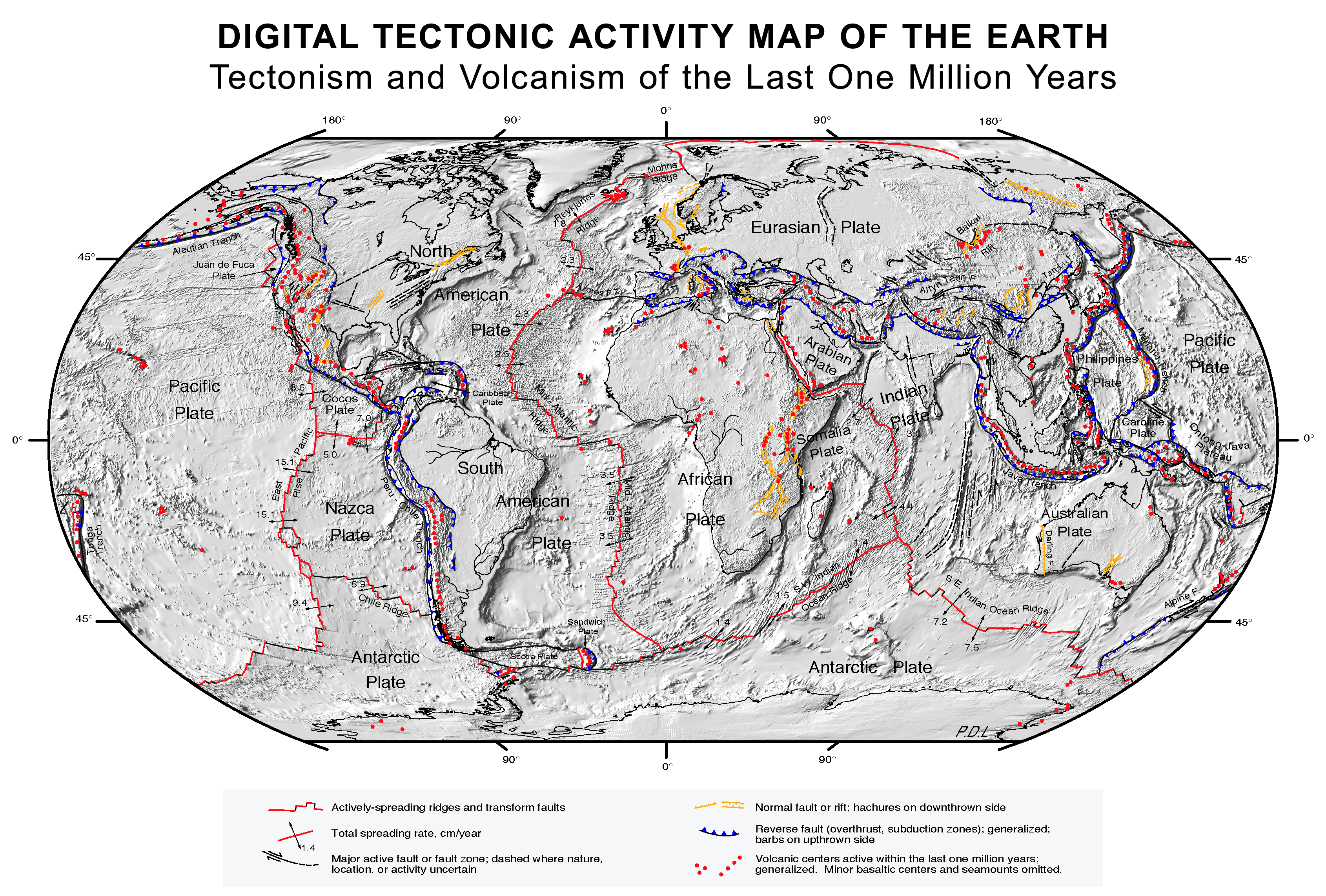
| DescriptionPlate tectonics map.gif |
English: Quake epicenters Digital Tectonic Activity Map of the Earth (DTAM): |
| Date | October 2002 |
| Source |
|
| Créé par |
NASA/Goddard Space Flight Center |
| Données géotemporelles | |
| Système de coordonnées | Robinson Projection |
| Géoréférencement | Géoréférencer la carte dans Wikimaps Warper Si c'est inapproprié, définissez warp_status = skip pour masquer. |
Conditions d’utilisation
| Public domainPublic domainfalsefalse |
| Ce fichier provient de la NASA. Sauf exception, les documents créés par la NASA ne sont pas soumis à copyright. Pour plus d'informations, voir la politique de copyright de la NASA. | ||
 |
Attention :
|
Légendes
Ajoutez en une ligne la description de ce que représente ce fichier
Tectonic activity map
Éléments décrits dans ce fichier
dépeint
Historique du fichier
Cliquer sur une date et heure pour voir le fichier tel qu'il était à ce moment-là.
| Date et heure | Vignette | Dimensions | Utilisateur | Commentaire | |
|---|---|---|---|---|---|
| actuel | 26 août 2017 à 11:41 | | 3 380 × 2 285 (2,63 Mio) | Nagualdesign | White background. |
| 26 août 2017 à 11:20 |  | 3 380 × 2 285 (2,63 Mio) | Nagualdesign | Minor correction. | |
| 26 août 2017 à 11:16 |  | 3 380 × 2 285 (2,63 Mio) | Nagualdesign | Rearranged elements, removed clutter. | |
| 16 avril 2011 à 12:52 |  | 3 577 × 2 313 (2,68 Mio) | Michael Metzger | uploaded a new version of this file with much higher resolution | |
| 8 octobre 2007 à 14:08 |  | 1 280 × 838 (359 kio) | Geni | rmed nasa logo | |
| 17 février 2005 à 05:19 |  | 1 280 × 838 (360 kio) | Quadell | Plate Tectonics map ([http://epod.usra.edu/archive/epodviewer.php3?oid=39392 source]){{PD-USGov-NASA}}Category:World mapsCategory:Plate tectonicsCategory:Continental drift |
Utilisation du fichier
Les 3 pages suivantes utilisent ce fichier :
Usage global du fichier
Les autres wikis suivants utilisent ce fichier :
- Utilisation sur af.wikipedia.org
- Utilisation sur an.wikipedia.org
- Utilisation sur ar.wikipedia.org
- Utilisation sur az.wikipedia.org
- Utilisation sur bcl.wikipedia.org
- Utilisation sur be.wikipedia.org
- Utilisation sur bn.wikipedia.org
- Utilisation sur ca.wikipedia.org
- Utilisation sur cs.wikipedia.org
- Utilisation sur cv.wikipedia.org
- Utilisation sur da.wikipedia.org
- Utilisation sur de.wikipedia.org
- Utilisation sur el.wikipedia.org
- Utilisation sur en.wikipedia.org
- Plate tectonics
- List of tectonic plate interactions
- Lists of volcanoes
- Tectonics
- List of tectonic plates
- Wikipedia:WikiProject Seamounts/Images
- User talk:Newyorkadam
- User talk:Muffin Wizard/Archive 5
- Timeline of the development of tectonophysics (after 1952)
- User talk:PWNGWN
- User talk:Sahara4u/Archive 4
- User talk:Ryan115
- User talk:A.Minkowiski
- User talk:Simon Adler/Archive 1
- User talk:Geirfuglasker
- User talk:EMachine03/Archive
- User talk:BluJay
- User talk:TheEditor867
- User talk:CrawfordLou
- User talk:CryOCed
Voir davantage sur l’utilisation globale de ce fichier.
Ce document provient de « https://fr.wikipedia.org/wiki/Fichier:Plate_tectonics_map.gif ».