Fichier:Thermohaline_Circulation_2.png
De Wikipedia, l'encyclopédie encyclopedia
Taille de cet aperçu : 800 × 502 pixels. Autres résolutions : 320 × 201 pixels | 640 × 401 pixels | 1 100 × 690 pixels.
Fichier d’origine (1 100 × 690 pixels, taille du fichier : 122 kio, type MIME : image/png)
Ce fichier et sa description proviennent de Wikimedia Commons.
Description
| DescriptionThermohaline Circulation 2.png |
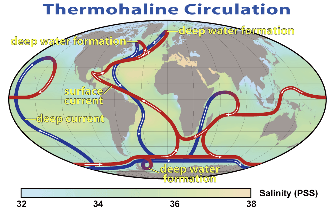
English: This map shows the pattern of thermohaline circulation also known as "meridional overturning circulation". This collection of currents is responsible for the large-scale exchange of water masses in the ocean, including providing oxygen to the deep ocean. The entire circulation pattern takes ~2000 years.
Deutsch: Thermohaline Zirkulation und die Entstehung von kaltem, dichtem Tiefenwasser im Nordmeer |
||||||
| Date | |||||||
| Source | NASA Earth Observatory | ||||||
| Auteur | Robert Simmon, NASA. Minor modifications by Robert A. Rohde also released to the public domain | ||||||
| Autorisation (Réutilisation de ce fichier) |
|
||||||
| Autres versions |
 |


|
Cette image (de type meteorology) devrait être recréée dans un format vectoriel, en tant que fichier SVG. Cela offrirait plusieurs avantages : voir Commons:Media for cleanup pour plus d'informations. Si une version SVG de cette image est déjà disponible, merci de bien vouloir l'envoyer. Après cela, remplacez ce modèle par {{vector version available|nouveau nom d'image.svg}}.
|
Légendes
Ajoutez en une ligne la description de ce que représente ce fichier
Éléments décrits dans ce fichier
dépeint
29 mars 2008
Historique du fichier
Cliquer sur une date et heure pour voir le fichier tel qu'il était à ce moment-là.
| Date et heure | Vignette | Dimensions | Utilisateur | Commentaire | |
|---|---|---|---|---|---|
| actuel | 29 mars 2008 à 22:08 | | 1 100 × 690 (122 kio) | Dragons flight | {{Information |Description=This map shows the pattern of w:thermohaline circulation also known as "meridional overturning circulation". This collection of currents is responsible for the large-scale exchange of water masses in the ocean, including p |
Utilisation du fichier
Les 2 pages suivantes utilisent ce fichier :
Usage global du fichier
Les autres wikis suivants utilisent ce fichier :
- Utilisation sur ar.wikipedia.org
- Utilisation sur ast.wikipedia.org
- Utilisation sur az.wikipedia.org
- Utilisation sur ba.wikipedia.org
- Utilisation sur bcl.wikipedia.org
- Utilisation sur be.wikipedia.org
- Utilisation sur bg.wikipedia.org
- Utilisation sur bh.wikipedia.org
- Utilisation sur bn.wikipedia.org
- Utilisation sur bs.wikipedia.org
- Utilisation sur bxr.wikipedia.org
- Utilisation sur ca.wikipedia.org
- Utilisation sur cdo.wikipedia.org
- Utilisation sur cs.wikipedia.org
- Utilisation sur da.wikipedia.org
- Utilisation sur da.wikibooks.org
- Utilisation sur de.wikipedia.org
- Utilisation sur el.wikipedia.org
- Utilisation sur en.wikipedia.org
- Norwegian Sea
- Oceanography
- Talk:Ice
- Physical oceanography
- Thermohaline circulation
- Abrupt climate change
- Environmental isotopes
- Atlantic meridional overturning circulation
- Subantarctic
- Outline of oceanography
- Wild fisheries
- Sea
- Ocean
- User:Richard Hobbs/Seismic oceanography
- User:Vivrkn/sandbox
- Talk:Ice/GA1
- Utilisation sur en.wikibooks.org
Voir davantage sur l’utilisation globale de ce fichier.
Ce document provient de « https://fr.wikipedia.org/wiki/Fichier:Thermohaline_Circulation_2.png ».