File:Herodotus_world_map-de.svg
De Wikipedia, l'encyclopédie encyclopedia

Taille de cet aperçu PNG pour ce fichier SVG : 788 × 476 pixels. Autres résolutions : 320 × 193 pixels | 640 × 387 pixels | 1 024 × 619 pixels | 1 280 × 773 pixels | 2 560 × 1 546 pixels.
Fichier d’origine (Fichier SVG, nominalement de 788 × 476 pixels, taille : 277 kio)
Ce fichier et sa description proviennent de Wikimedia Commons.
Description
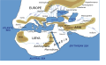
| DescriptionHerodotus world map-de.svg |
[modifier]
Català: Mapa del món segons Heròdot, segle V a. C. Deutsch: Mögliche Weltdarstellung nach den Historien des Herodot (5. Jahrhundert v. Chr) English: Possibly what the world according to Herodotus looked like (5th century BC). Español: Mapa del mundo según Heródoto, siglo V a. C. Euskara: Munduaren balizko mapa Herodotoren arabera, K. a. V. mendean Français : Reconstruction du monde décrit par Hérodote dans son Enquête (Ve siècle av. J.-C.). Hrvatski: Rekonstruirana karta svijeta prema Herodotu (5. st. pr. Kr.) Italiano: Carta Geografica da Herodotus Ελληνικά: Χάρτης της Οικουμένης κατά τον Ηρόδοτο, τον 5 αιώνα π. Χ. ქართული: ჰეროდოტეს მსოფლიოს რუკა ქართულად ) ไทย: แผนที่โลกที่ใกล้เคียงตามคำกล่าวของเฮอรอโดทัสมากที่สุด (ศตวรรษที่ 5 ก่อนคริสตกาล) 中文: 希罗多德笔下的世界,译名主要依照《历史》(徐松岩译) 注:唯极南的Macrobian人未能在英文维基百科中提到的3.114的英汉译本对应位置找到,只提到了埃塞俄比亚地区的人是人类中身材最为高大的,且条目中提及的防腐技术、寿命等描述也在书中对应埃塞俄比亚人。 العربية : خارطة العالم كما يُحتمل أن تصوره هيرودوت خلال القرن الخامس ق.م.. کوردی: نەخشەی جیھان بەو شێوەیەی کە ھیرۆدیۆت پێشبینی کردووە لە ( قەرنی پێنج پێش میلاد |
|||
| Date | ||||
| Source | Own work (based on the GIF by Marco Prins and Jona Lendering from www.livius.org, see http://www.livius.org/a/1/maps/herodotus_map.gif, with fixes from http://www.mediterranees.net/geographie/herodote/cartes.html, http://www.meer.org/herodotus-world-map-1a.jpg and http://www.henry-davis.com/MAPS/Ancientimages/109A.GIF). | |||
| Auteur | User:Bibi Saint-Pol | |||
| Autorisation (Réutilisation de ce fichier) |
|
|||
| Autres versions |
[modifier]
|
|||
| SVG information InfoField | Le code de ce fichier SVG n'est pas valide en raison d'une erreur. Cette carte SVG utilise du texte encapsulé qui peut être traduit facilement à l'aide d'un éditeur de texte. |


Légendes
Ajoutez en une ligne la description de ce que représente ce fichier
Weltkarte nach Herodot
Éléments décrits dans ce fichier
dépeint
15 décembre 2006
Historique du fichier
Cliquer sur une date et heure pour voir le fichier tel qu'il était à ce moment-là.
| Date et heure | Vignette | Dimensions | Utilisateur | Commentaire | |
|---|---|---|---|---|---|
| actuel | 8 février 2010 à 18:56 | | 788 × 476 (277 kio) | Bibi Saint-Pol | fix typo (Schwartzes Meer) |
| 15 décembre 2006 à 06:09 |  | 788 × 476 (277 kio) | Bibi Saint-Pol | {{Inkscape}} {{Information |Description= {{en|Possibly what the map of the world by Herodotus looked like (5th century BC).}} |Source=Own work (based on the GIF by Marco Prins and Jona Lendering from www.livius.org, see http://www.livius |
Utilisation du fichier
Aucune page n’utilise ce fichier.
Usage global du fichier
Les autres wikis suivants utilisent ce fichier :
- Utilisation sur als.wikipedia.org
- Utilisation sur de.wikipedia.org
- Utilisation sur frr.wikipedia.org
- Utilisation sur it.wikipedia.org
- Utilisation sur nl.wikipedia.org
- Utilisation sur sk.wikipedia.org
- Utilisation sur stq.wikipedia.org
Ce document provient de « https://fr.wikipedia.org/wiki/Fichier:Herodotus_world_map-de.svg ».