File:NPS_white-house-map.gif
ויקיפדיה האנציקלופדיה encyclopedia

גודל התצוגה המקדימה הזאת: 386 × 600 פיקסלים. רזולוציות אחרות: 154 × 240 פיקסלים | 309 × 480 פיקסלים | 494 × 768 פיקסלים | 659 × 1,024 פיקסלים | 1,560 × 2,423 פיקסלים.
לקובץ המקורי (1,560 × 2,423 פיקסלים, גודל הקובץ: 361 ק"ב, סוג MIME: image/gif, 0.1 שניות)
| זהו קובץ שמקורו במיזם ויקישיתוף. תיאורו בדף תיאור הקובץ המקורי (בעברית) מוצג למטה. |
תקציר
| תיאורNPS white-house-map.gif |
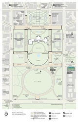
English: This President’s Park map shows the entire grounds of the White House, just off the National Mall to the north. |
| תאריך יצירה | |
| מקור | U.S. National Park Service (http://npmaps.com/wp-content/uploads/white-house-map.gif) |
| יוצר | U.S. National Park Service, restoration/cleanup by Matt Holly |
| גרסאות אחרות |
 |
רישיון
| Public domainPublic domainfalsefalse |
| This image or media file contains material based on a work of a National Park Service employee, created as part of that person's official duties. As a work of the U.S. federal government, such work is in the public domain in the United States. See the NPS website and NPS copyright policy for more information. |
כיתובים
נא להוסיף משפט שמסביר מה הקובץ מייצג
פריטים שמוצגים בקובץ הזה
מוצג
27 בנובמבר 2016
היסטוריית הקובץ
ניתן ללחוץ על תאריך/שעה כדי לראות את הקובץ כפי שנראה באותו זמן.
| תאריך/שעה | תמונה ממוזערת | ממדים | משתמש | הערה | |
|---|---|---|---|---|---|
| נוכחית | 04:57, 17 במאי 2017 | | 2,423 × 1,560 (361 ק"ב) | RKBot | =={{int:filedesc}}== {{Information |description= {{en|1=This President’s Park map shows the entire grounds of the White House, just off the National Mall to the north.}} |date= 2016-11-27 |source= U.S. National Park Service (http://npmaps.com/wp-cont... |
שימוש בקובץ
![]() אין בוויקיפדיה דפים המשתמשים בקובץ זה.
אין בוויקיפדיה דפים המשתמשים בקובץ זה.
שימוש גלובלי בקובץ
אתרי הוויקי השונים הבאים משתמשים בקובץ זה:
- שימוש באתר fi.wikipedia.org