File:Palestine_election_map.PNG
ויקיפדיה האנציקלופדיה encyclopedia
גודל התצוגה המקדימה הזאת: 437 × 600 פיקסלים. רזולוציות אחרות: 175 × 240 פיקסלים | 350 × 480 פיקסלים | 560 × 768 פיקסלים | 1,115 × 1,530 פיקסלים.
לקובץ המקורי (1,115 × 1,530 פיקסלים, גודל הקובץ: 106 ק"ב, סוג MIME: image/png)
| זהו קובץ שמקורו במיזם ויקישיתוף. תיאורו בדף תיאור הקובץ המקורי (בעברית) מוצג למטה. |

|
יש ליצור מחדש את התמונה election map הזו באמצעות גרפיקה וקטורית כדוגמת קובץ SVG. לפעולה זו מספר יתרונות, כפי שניתן לקרוא (באנגלית) בדף Commons:Media for cleanup. אם ברשותכם קובץ SVG, אנא העלו אותו. לאחר מכן, החליפו תבנית זו בתבנית
{{vector version available|שם הקובץ.svg}} |
תקציר
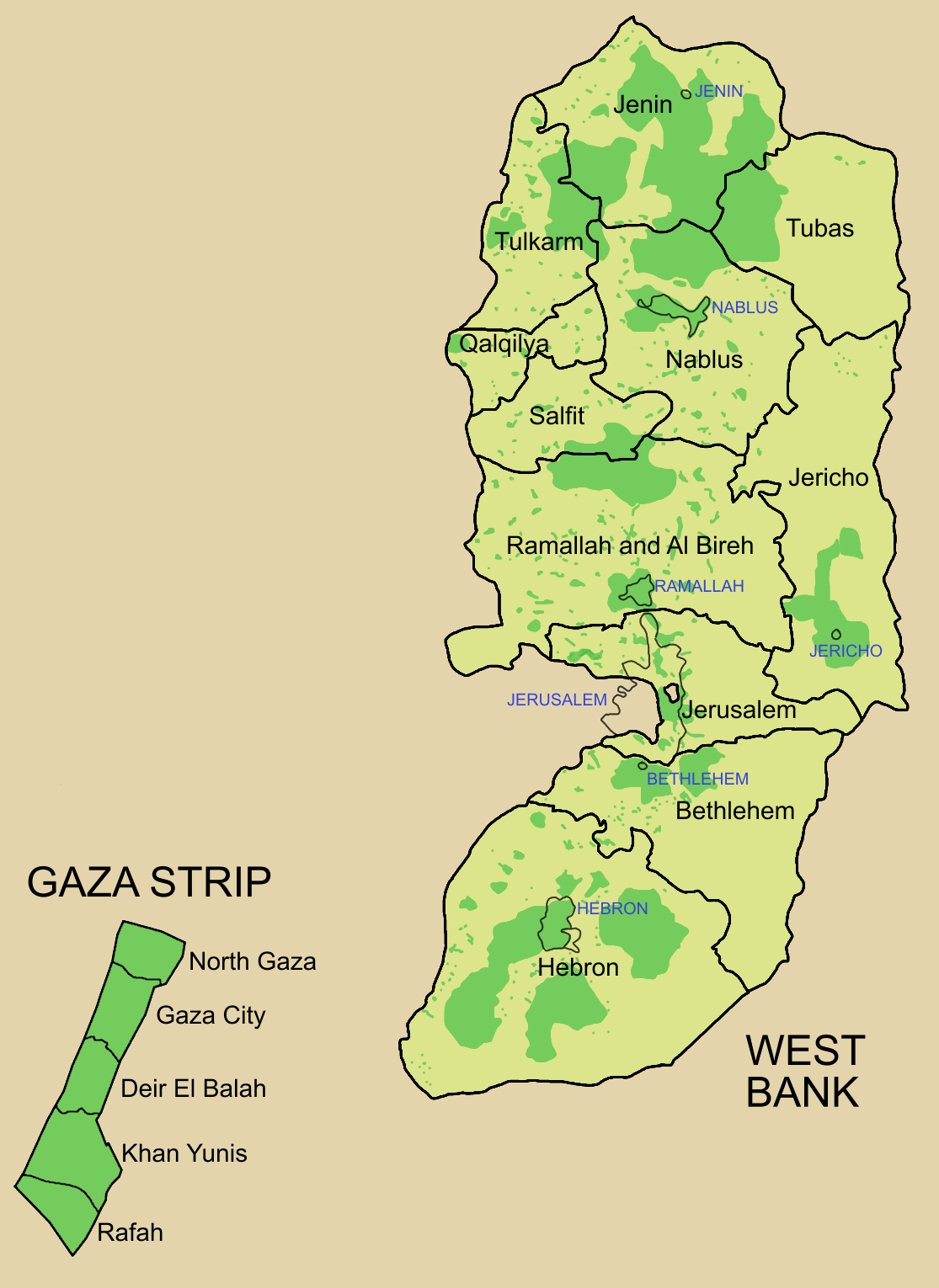
Palestine divided into electoral districts (as of 2006), marked with thick black borders. (thinner borders show boundaries of cities, with city names marked in blue). Green shows areas of formal Palestinian authority. Map made using information from other maps such as this. There is a map of the West Bank and Gaza governates from 1995 here
רישיון

|
מוענקת בכך הרשות להעתיק, להפיץ או לשנות את המסמך הזה, לפי תנאי הרישיון לשימוש חופשי במסמכים של גנו, גרסה 1.2 או כל גרסה מאוחרת יותר שתפורסם על־ידי המוסד לתוכנה חופשית; ללא פרקים קבועים, ללא טקסט עטיפה קדמית וללא טקסט עטיפה אחורית. עותק של הרישיון כלול בפרק שכותרתו הרישיון לשימוש חופשי במסמכים של גנו.http://www.gnu.org/copyleft/fdl.htmlGFDLGNU Free Documentation Licensetruetrue |
| הקובץ הזה מתפרסם לפי תנאי רישיון קריאייטיב קומונז ייחוס-שיתוף זהה 3.0 לא מותאם. | ||
| ||
| תבנית רישוי זו הוספה לקובץ כחלק מעדכון רישיון GFDL.http://creativecommons.org/licenses/by-sa/3.0/CC BY-SA 3.0Creative Commons Attribution-Share Alike 3.0truetrue |
כיתובים
נפות הרשות הפלסטינית
The 16 Governorates of Palestine; green shows areas of Palestinian authority
פריטים שמוצגים בקובץ הזה
מוצג
היסטוריית הקובץ
ניתן ללחוץ על תאריך/שעה כדי לראות את הקובץ כפי שנראה באותו זמן.
| תאריך/שעה | תמונה ממוזערת | ממדים | משתמש | הערה | |
|---|---|---|---|---|---|
| נוכחית | 12:57, 5 ביולי 2006 | | 1,530 × 1,115 (106 ק"ב) | Roke~commonswiki | request to make all of gaza strip dark green |
| 08:38, 28 בינואר 2006 |  | 1,530 × 1,115 (104 ק"ב) | Roke~commonswiki | Palestine divided into electoral districts, marked with black borders. Green shows areas of formal Palestinian authority. I made the map, using information from other maps such as [http://www.nytimes.com/imagepages/2006/01/25/international/20060125_palest |
שימוש בקובץ
הדף הבא משתמש בקובץ הזה:
שימוש גלובלי בקובץ
אתרי הוויקי השונים הבאים משתמשים בקובץ זה:
- שימוש באתר arz.wikipedia.org
- שימוש באתר bcl.wikipedia.org
- שימוש באתר be.wikipedia.org
- שימוש באתר bn.wikipedia.org
- שימוש באתר br.wikipedia.org
- שימוש באתר ca.wikipedia.org
- שימוש באתר cs.wikipedia.org
- שימוש באתר en.wikipedia.org
- Palestinian territories
- State of Palestine
- List of cities administered by the Palestinian Authority
- Governorates of Palestine
- Template talk:Governorates of the State of Palestine
- Next Palestinian legislative election
- Condoleezza Rice's tenure as Secretary of State
- Talk:Next Palestinian legislative election
- 2006 Palestinian legislative election
- User:Falcaorib/Israel and Palestine
- שימוש באתר en.wikinews.org
- שימוש באתר eo.wikipedia.org
- שימוש באתר es.wikipedia.org
- שימוש באתר es.wikinews.org
- שימוש באתר fa.wikipedia.org
- שימוש באתר fr.wikipedia.org
- שימוש באתר gv.wikipedia.org
- שימוש באתר hy.wikipedia.org
- שימוש באתר id.wikipedia.org
- שימוש באתר it.wikipedia.org
- שימוש באתר ja.wikipedia.org
- שימוש באתר ja.wikinews.org
- שימוש באתר ko.wikipedia.org
- שימוש באתר ms.wikipedia.org
- שימוש באתר nap.wikipedia.org