File:Tectonic_plates_hotspots_he.jpg
ויקיפדיה האנציקלופדיה encyclopedia
לקובץ המקורי (2,000 × 1,364 פיקסלים, גודל הקובץ: 413 ק"ב, סוג MIME: image/jpeg)
| זהו קובץ שמקורו במיזם ויקישיתוף. תיאורו בדף תיאור הקובץ המקורי (בעברית) מוצג למטה. |
| תיאורTectonic plates hotspots he.jpg |
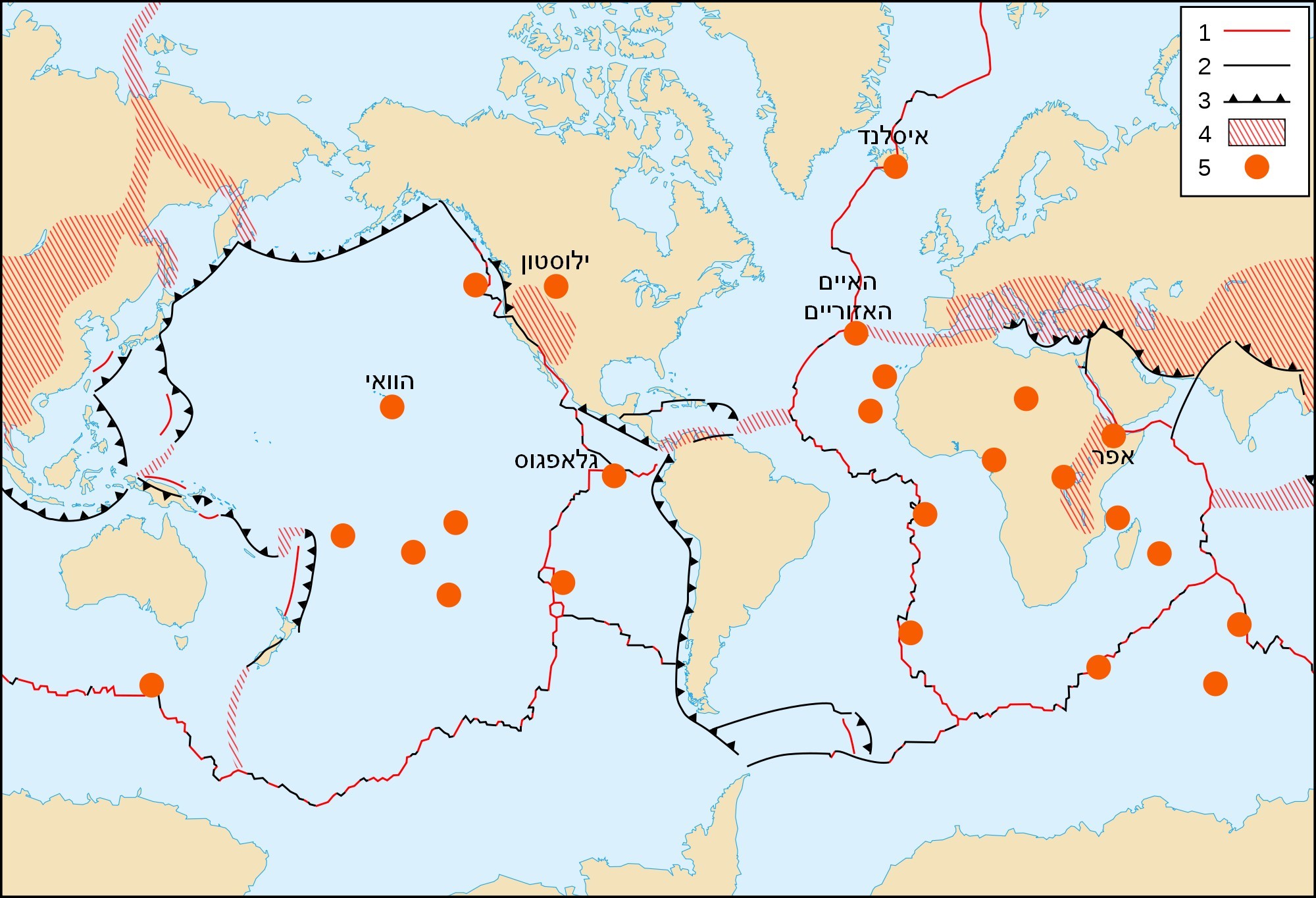
English: World map in English of selected prominent geological hotspots. Français : Carte en anglais des principaux points chauds géologiques mondiaux. עברית: מפה עולמית של לוחות טקטוניים ונקודות חמות |
| תאריך יצירה | (UTC) |
| מקור | |
| יוצר |
|
| Public domainPublic domainfalsefalse |
This image is in the public domain in the United States because it only contains materials that originally came from the United States Geological Survey, an agency of the United States Department of the Interior. For more information, see the official USGS copyright policy.
Bahasa Indonesia ∙ català ∙ čeština ∙ Deutsch ∙ eesti ∙ English ∙ español ∙ français ∙ galego ∙ italiano ∙ Nederlands ∙ português ∙ polski ∙ sicilianu ∙ suomi ∙ Tiếng Việt ∙ Türkçe ∙ български ∙ македонски ∙ русский ∙ മലയാളം ∙ 한국어 ∙ 日本語 ∙ 中文 ∙ 中文(简体) ∙ 中文(繁體) ∙ العربية ∙ فارسی ∙ +/− |
| Public domainPublic domainfalsefalse |
| This work was previously under Public Domain, or a Free License. It has been digitally enhanced and/or modified. This derivative work has been (or is hereby) released into the public domain by its author, [[:{{{1}}}:User:{{{3}}}|{{{3}}}]] at the [[:{{{1}}}:|{{{2}}}]] project. This applies worldwide. In some countries this is not legally possible; if so: |
יומן העלאה מקורי
This image is a derivative work of the following images:
- File:Tectonic_plates_hotspots-en.svg licensed with PD-USGov-USGS, PD-retouched-user-w
- 2008-06-02T21:38:19Z Sting 1100x750 (381552 Bytes) Display bug correction
- 2008-03-02T08:58:28Z QWerk 1100x750 (186026 Bytes) Cleaned code. Lets see does it work now.
- 2006-10-21T23:25:55Z Sting 0x0 (406117 Bytes) * '''Key :''' :'''1 :''' Divergent plate boundaries ; :'''2 :''' Convergent plate boundaries ; :'''3 :''' Transform plate boundaries ; :'''4 :''' Plate boundary zones ; :'''5 :''' Selected prominent hotspots. {{Information
Uploaded with derivativeFX
כיתובים
פריטים שמוצגים בקובץ הזה
מוצג
4 באוקטובר 2010
היסטוריית הקובץ
ניתן ללחוץ על תאריך/שעה כדי לראות את הקובץ כפי שנראה באותו זמן.
| תאריך/שעה | תמונה ממוזערת | ממדים | משתמש | הערה | |
|---|---|---|---|---|---|
| נוכחית | 16:27, 4 באוקטובר 2010 | | 1,364 × 2,000 (413 ק"ב) | דקי | {{Information |Description={{en|World map in English of selected prominent geological hotspots.}} {{fr|Carte en anglais des principaux points chauds géologiques mondiaux.}} {{he|מפה עולמית של לוחות טקטוניים ונקודות חמות |
שימוש בקובץ
הדפים הבאים משתמשים בקובץ הזה:
מטא־נתונים
קובץ זה מכיל מידע נוסף, שכנראה הגיע ממצלמה דיגיטלית או מסורק שבהם הקובץ נוצר או עבר דיגיטציה.
אם הקובץ שונה ממצבו הראשוני, כמה מהנתונים להלן עלולים שלא לשקף באופן מלא את הקובץ הנוכחי.
| _error | 0 |
|---|