קובץ:Ein_Gev_-_Al_Samra_-_Al_Hamma_Demilitarized_Zone.png
ויקיפדיה האנציקלופדיה encyclopedia
לקובץ המקורי (1,337 × 2,354 פיקסלים, גודל הקובץ: 160 ק"ב, סוג MIME: image/png)
| זהו קובץ שמקורו במיזם ויקישיתוף. תיאורו בדף תיאור הקובץ המקורי (בעברית) מוצג למטה. |
תקציר
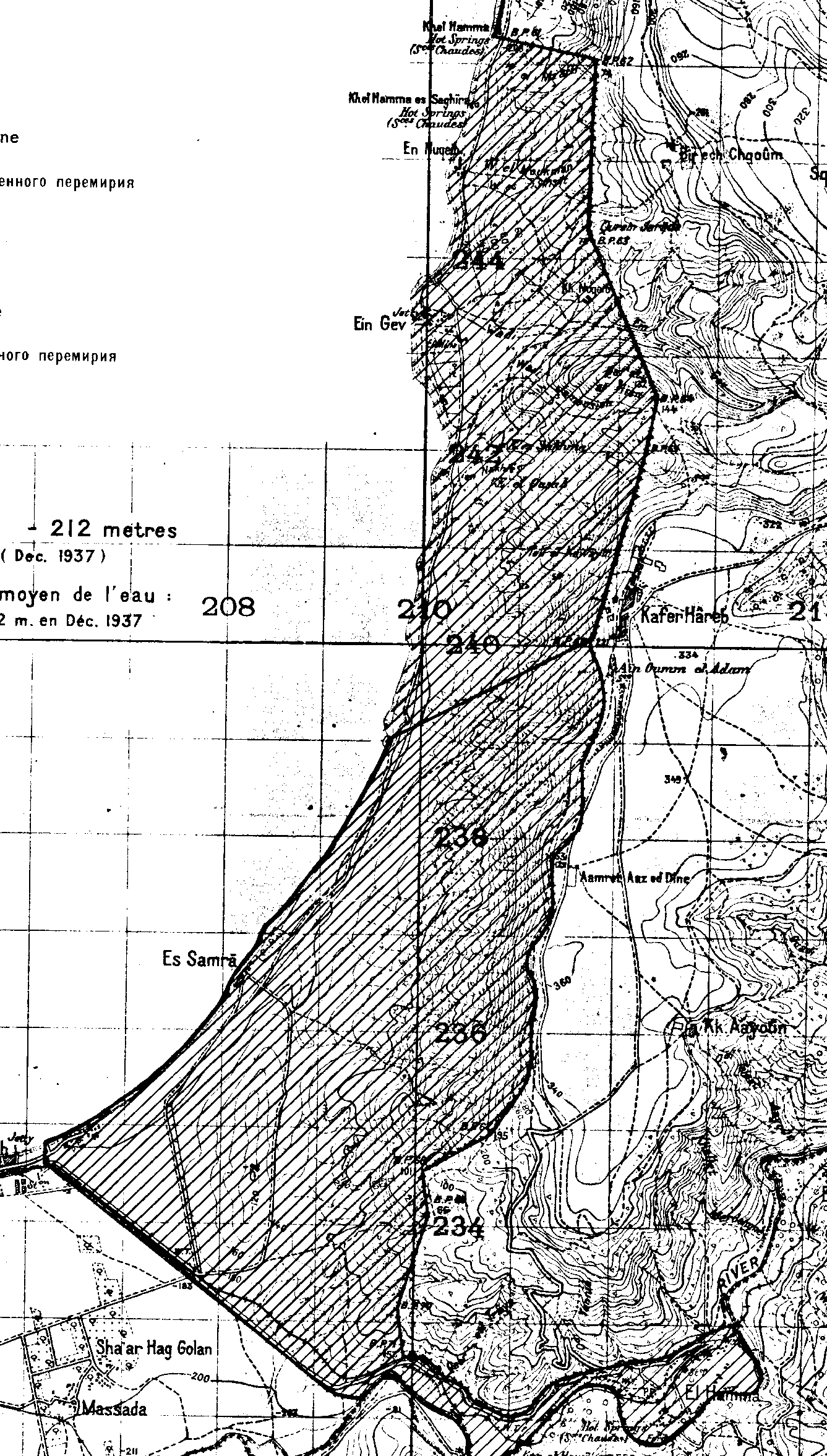
| תיאורEin Gev - Al Samra - Al Hamma Demilitarized Zone.png |
English: Map showing the Israeli-Syrian General Armistice Agreement, around the Golan Heights region |
|||
| תאריך יצירה | ||||
| מקור | Israeli-Syrian General Armistice Agreement [1] | |||
| יוצר | United Nations | |||
| גרסאות אחרות |
|
.png)
רישיון
| Public domainPublic domainfalsefalse |
| This image is a map derived from a United Nations map.
Unless stated otherwise, UN maps are to be considered in the public domain. This applies worldwide. UN maps are, in principle, open source material and you can use them in your work or for making your own map. UN requests however that you delete the UN name, logo and reference number upon any modification to the map. Content of your map will be your responsibility. You can state in your publication, if you wish, something like: based on UN map … (map name, map number, revision number and date). See: Geospatial Information Section. And: Geospatial, location data for a better world. |
 |
היסטוריית הקובץ
ניתן ללחוץ על תאריך/שעה כדי לראות את הקובץ כפי שנראה באותו זמן.
| תאריך/שעה | תמונה ממוזערת | ממדים | משתמש | הערה | |
|---|---|---|---|---|---|
| נוכחית | 16:19, 21 בפברואר 2022 | | 2,354 × 1,337 (160 ק"ב) | Onceinawhile | File:1949 Israeli-Syrian General Armistice Agreement (png).png cropped 68 % horizontally, 80 % vertically using CropTool with precise mode. |
.png)
שימוש בקובץ
הדפים הבאים משתמשים בקובץ הזה:
שימוש גלובלי בקובץ
אתרי הוויקי השונים הבאים משתמשים בקובץ זה:
- שימוש באתר en.wikipedia.org
מטא־נתונים
קובץ זה מכיל מידע נוסף, שכנראה הגיע ממצלמה דיגיטלית או מסורק שבהם הקובץ נוצר או עבר דיגיטציה.
אם הקובץ שונה ממצבו הראשוני, כמה מהנתונים להלן עלולים שלא לשקף באופן מלא את הקובץ הנוכחי.
| התאריך והשעה של שינוי הקובץ | 13:18, 21 בפברואר 2022 |
|---|