Fail:Iberian_Peninsula_antique_map.jpg
From Wikipedia, the free encyclopedia
Fail asli (2,096 × 1,700 piksel, saiz fail: 5.81 MB, jenis MIME: image/jpeg)
Fail ini dari Wikimedia Commons dan mungkin digunakan oleh projek lain. Penerangan pada laman penerangan failnya di sana ditunjukkan di bawah.
|
Ringkasan
| KeteranganIberian Peninsula antique map.jpg |
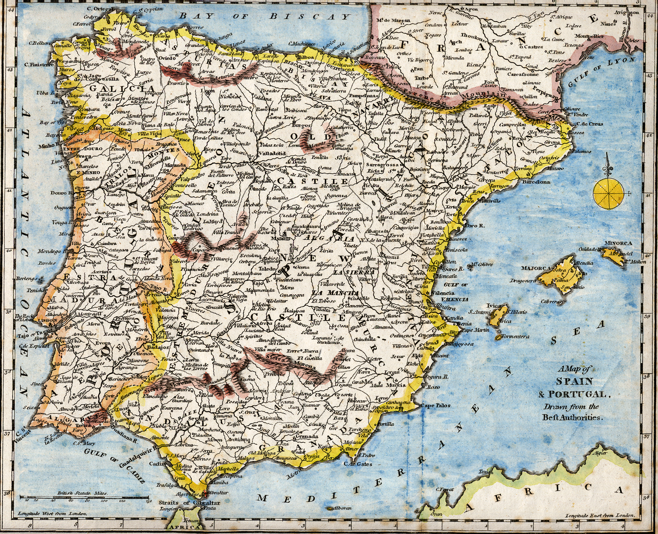
English: 18th century hand-coloured engraved map of the Iberian peninsula depicting various topographical features of the land, as published in Robert Wilkinson's General Atlas, circa 1794. (Volume 2., page 666.)
Titl'd A Map of Spain & Portugal, Drawn from the Beſt Authorities Español: Mapa del siglo XVIII grabado al cobre e iluminado a mano, representando varias características topográficas de la Península Ibérica. Publicado en el atlas general de Robert Wilkinson (volumen 2., página 666.)
Português: Mapa do século XVIII gravado em cobre e iluminado a mão, representando várias características topográficas da Península Ibérica. Publicado no atlas geral de Robert Wilkinson (volume 2., página 666.)
Català: Mapa del segle XVIII grabat al coure i il·luminat a mà, representant diverses característiques topogràfiques de la Península Ibèrica. Publicat en l'atles general de Robert Walkinson (volum 2., pàgina 666) |
|||||||||||||||||||
| Tarikh | circa 1794 | |||||||||||||||||||
| Sumber | Scanned from my personal collection. (scanned by User:RedCoat) | |||||||||||||||||||
| Pengarang |
creator QS:P170,Q7351069 |
|||||||||||||||||||
| Location InfoField | [published at] No. 58 Cornhill London, England | |||||||||||||||||||
Perlesenan
| Public domainPublic domainfalsefalse |
|
Karya ini berada dalam domain awam di negara-negara dengan tempoh hak cipta hayat pencipta ditambah 70 tahun atau kurang.
| |
| Fail ini telah dikenal pasti sebagai bebas daripada sekatan-sekatan yang dikenali mengikut undang-undang hak cipta, termasuk semua hak berkaitan dan berjiran. | |
https://creativecommons.org/publicdomain/mark/1.0/PDMCreative Commons Public Domain Mark 1.0falsefalse
Sejarah fail
Klik pada tarikh/waktu untuk melihat rupa fail tersebut pada waktu itu.
| Tarikh/Waktu | Gambar kenit | Ukuran | Pengguna | Komen | |
|---|---|---|---|---|---|
| semasa | 17:01, 28 Oktober 2007 | | 2,096 × 1,700 (5.81 MB) | RedCoat | {{Information | Description ={{en|18th century hand-coloured engraved map of the Iberian peninsula depicting various topographical features of the land, as published in Robert Wilkinson's ''General Atlas'', circa 1794. |
Penggunaan fail
3 buah laman berikut menggunakan fail ini:
Penggunaan fail sejagat
Fail ini digunakan oleh wiki-wiki lain yang berikut:
- Penggunaan di ar.wikipedia.org
- Penggunaan di ast.wikipedia.org
- Penggunaan di azb.wikipedia.org
- Penggunaan di ba.wikipedia.org
- Penggunaan di bg.wikipedia.org
- Penggunaan di ca.wikipedia.org
- Penggunaan di de.wikipedia.org
- Penggunaan di en.wikipedia.org
- History of Spain
- Portal:Spain
- Portal:Portugal
- Portal:Portugal/Recognized content
- Portal:European Union/Selected picture
- Portal:Maps/Selected picture
- Loa (Spanish play)
- Wikipedia:Featured pictures thumbs/07
- Wikipedia:WikiProject Portugal/FAC
- Portal:European Union/Selected picture/5
- Wikipedia:WikiProject Gibraltar
- Wikipedia:Featured picture candidates/July-2007
- Wikipedia:Wikipedia Signpost/2007-07-23/Features and admins
- Wikipedia:Featured picture candidates/Iberian Peninsula antique map.jpg
- Wikipedia:Wikipedia Signpost/2007-07-23/SPV
- Robert Wilkinson (cartographer)
- User talk:RedCoat10/Archive 2
- Portal:Maps/Selected picture/9
- Wikipedia:Picture of the day/November 2007
- Template:POTD/2007-11-11
- User talk:RedCoat10/Archive 3
- Portal:Spain/Exemplary content
- Wikipedia:Featured pictures/Diagrams, drawings, and maps/Maps
- Wikipedia:WikiProject Spain/Recognized content
- Iberian ship development, 1400–1600
- Portal:Geography/Selected picture
- Wikipedia:WikiProject Portugal/Recognized content
- Wikipedia:Wikipedia Signpost/Single/2007-07-23
- Penggunaan di es.wikipedia.org
- Penggunaan di eu.wikipedia.org
- Penggunaan di fa.wikipedia.org
- Penggunaan di it.wikipedia.org
- Penggunaan di mg.wikipedia.org
- Penggunaan di ml.wikipedia.org
- Penggunaan di mwl.wikipedia.org
- Penggunaan di nn.wikipedia.org
- Penggunaan di no.wikipedia.org
- Penggunaan di th.wikipedia.org
Lihat banyak lagi penggunaan sejagat bagi fail ini.
Metadata
Fail ini mengandungi maklumat tambahan daripada kamera digital atau pengimbas yang digunakan untuk menghasilkannya. Jika fail ini telah diubah suai daripada rupa asalnya, beberapa butiran dalam maklumat ini mungkin sudah tidak relevan.
| Haluan | Normal |
|---|---|
| Leraian mengufuk | 200 dpi |
| Leraian menegak | 200 dpi |
| Perisian digunakan | Adobe Photoshop Elements 2.0 |
| Tarikh dan waktu fail diubah | 22:34, 16 Jun 2007 |
| Ruang warna | Tidak tertentukur |