Bestand:Alemannic-Dialects-Map-English.png
Uit Wikipedia, de vrije encyclopedia
Grootte van deze voorvertoning: 800 × 571 pixels. Andere resoluties: 320 × 229 pixels | 640 × 457 pixels | 1.024 × 731 pixels | 1.400 × 1.000 pixels.
Oorspronkelijk bestand (1.400 × 1.000 pixels, bestandsgrootte: 838 kB, MIME-type: image/png)
| Dit is een bestand van Wikimedia Commons. Onderstaande beschrijving komt van de beschrijving van het bestand daar. |
| BeschrijvingAlemannic-Dialects-Map-English.png |
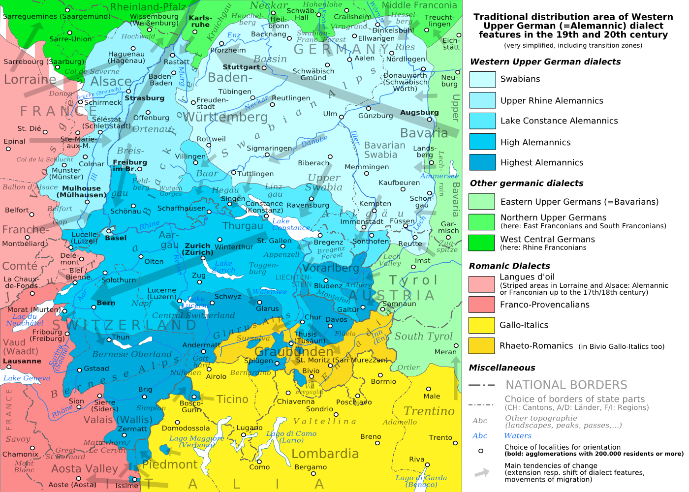
English: The traditional distribution area of the western upper German (=alemannic) dialects in the 19th and 20th century. Source: Mainly these articles in the German wikipedia: * Alemannische Dialekte * Grenzorte des alemannischen Dialektraums * Traditionell rätoromanischsprachiges Gebiet Graubündens and * Sprachen und Dialekte in der Region Elsass, plus the (newer) literature, which is mentioned there. This area, having been quite stable for at least some 300 years up to the 19th century, saw consecutively more or less strong changes by industrialisation, population growth, migrations and political developments. Deutsch: Das traditionelle Verbreitungsgebiet der westoberdeutschen (=alemannischen) Dialekte im 19. und 20. Jahrhundert. Grundlage: vor allem diese Artikel der deutschsprachigen Wikipedia: * Alemannische Dialekte * Grenzorte des alemannischen Dialektraums * Traditionell rätoromanischsprachiges Gebiet Graubündens und * Sprachen und Dialekte in der Region Elsass, sowie die dort jeweils genannte (jüngere) Literatur. Das bis ins 19. Jahrhundert für mindestens etwa 300 Jahre stabile Gebiet erfuhr nachfolgend durch Industrialisierung, Bevölkerungszuwächse und -bewegungen sowie politische Entwicklungen mehr oder weniger starke Änderungen. Français : Le secteur de distribution traditionnel des dialectes allemands supérieurs occidentaux (=alémannique) au 19e et 20e siècle. Source : Principalement ces articles dans le wikipedia allemand : * Alemannische Dialekte * Grenzorte des alemannischen Dialektraums * Traditionell rätoromanischsprachiges Gebiet Graubündens et * Sprachen und Dialekte in der Region Elsass, plus la littérature (plus jeune), qui est mentionnée là. Ce secteur, après avoir été stable jusqu'au 19e siècle pour au moins environ 300 années, scie consécutivement des changements plus ou moins forts par industrialisation, croissance démographique, migrations et développements politiques. Italiano: Area di distribuzione storica delle varianti linguistiche alto-tedesche occidentali(alemanniche) nel diciannovesimo e ventesimo secolo. Fonti: questa mappa si basa prevalentemente sui seguenti articoli in Wikipedia di lingua tedesca: * Alemannische Dialekte * Grenzorte des alemannischen Dialektraums * Traditionell rätoromanischsprachiges Gebiet Graubündens and * Sprachen und Dialekte in der Region Elsass, in aggiunta alla letteratura più recente menzionata in quegli articoli. Questa area, dopo essere rimasta piuttosto stabile per circa trecento anni fino all'inizio del diciannovesimo secolo, ha poi visto trasformazioni di diversa intensità causate dall'industrializzazione, dalla crescita demografica, dai processi migratori e dagli sviluppi politici. |
| Datum | (UTC) |
| Bron | |
| Auteur |
|
| Andere versies |
PNG:
PNG:
SVG:
SVG: SVG:
|


| Dit is een geretoucheerde foto, wat betekent dat de originele versie digitaal aangepast is. Aanpassingen: PNG-Version. Het origineel kan hier bekeken worden: Alemannic-Dialects-Map-English.svg. Aanpassingen gedaan door Testtube.
|
Ik, de auteursrechthebbende van dit werk, maak het hierbij onder de volgende licenties beschikbaar:
Dit bestand is gelicenseerd onder de Creative Commons-licenties Naamsvermelding-Gelijk delen 3.0 Unported, 2.5 Algemeen, 2.0 Algemeen en 1.0 Algemeen.
- De gebruiker mag:
- Delen – het werk kopiëren, verspreiden en doorgeven
- Remixen – afgeleide werken maken
- Onder de volgende voorwaarden:
- naamsvermelding – U moet op een gepaste manier aan naamsvermelding doen, een link naar de licentie geven, en aangeven of er wijzigingen in het werk zijn aangebracht. U mag dit op elke redelijke manier doen, maar niet zodanig dat de indruk wordt gewekt dat de licentiegever instemt met uw werk of uw gebruik van zijn werk.
- Gelijk delen – Als u het werk heeft geremixt, veranderd, of erop heeft voortgebouwd, moet u het gewijzigde materiaal verspreiden onder dezelfde licentie als het oorspronkelijke werk, of een daarmee compatibele licentie.

|
Toestemming wordt verleend voor het kopiëren, verspreiden en/of wijzigen van dit document onder de voorwaarden van de GNU-licentie voor vrije documentatie, versie 1.2 of enige latere versie als gepubliceerd door de Free Software Foundation; zonder Invariant Sections, zonder Front-Cover Texts, en zonder Back-Cover Texts. Een kopie van de licentie is opgenomen in de sectie GNU-licentie voor vrije documentatie.http://www.gnu.org/copyleft/fdl.htmlGFDLGNU Free Documentation Licensetruetrue |
U mag zelf één van de licenties kiezen.
Oorspronkelijk uploadlogboek
This image is a derivative work of the following images:
- File:Alemannic-Dialects-Map-English.svg licensed with Cc-by-sa-3.0,2.5,2.0,1.0, GFDL
- 2010-08-11T20:11:45Z Testtube 1400x1000 (482460 Bytes) Bugfix
- 2010-08-11T19:44:48Z Testtube 1400x1000 (482811 Bytes) Bugfix
- 2010-08-11T15:14:04Z Testtube 1400x1000 (482540 Bytes) {{Information |Description={{en|1=The traditional distribution area of the western upper german (=alemannic) dialects in the 19th and 20th century. Source: Mainly these articles in the german wikipedia: * [http://de.wikipedi
Uploaded with derivativeFX
Bijschriften
Beschrijf in één regel wat dit bestand voorstelt
Distribution area of the western upper German (alemannic) dialects
منطقة توزيع اللهجات الألمانية العليا (أليمانية)
Items getoond in dit bestand
beeldt af
18 aug 2010
image/png
efee0484adb9292b56ab1580e2159fa8553392a3
858.416 byte
1.000 pixel
1.400 pixel
Bestandsgeschiedenis
Klik op een datum/tijd om het bestand te zien zoals het destijds was.
| Datum/tijd | Miniatuur | Afmetingen | Gebruiker | Opmerking | |
|---|---|---|---|---|---|
| huidige versie | 19 aug 2010 19:01 | | 1.400 × 1.000 (838 kB) | Testtube~commonswiki | Bugfix. |
| 18 aug 2010 22:10 |  | 1.400 × 1.000 (837 kB) | Testtube~commonswiki | {{Information |Description={{en|1=The traditional distribution area of the western upper german (=alemannic) dialects in the 19th and 20th century. Source: Mainly these articles in the german wikipedia: * [http://de.wikipedia.org/wiki/Alemannische_Diale |
Bestandsgebruik
Dit bestand wordt op de volgende 2 pagina's gebruikt:
Globaal bestandsgebruik
De volgende andere wiki's gebruiken dit bestand:
- Gebruikt op am.wikipedia.org
- Gebruikt op ar.wikipedia.org
- Gebruikt op azb.wikipedia.org
- Gebruikt op be.wikipedia.org
- Gebruikt op bg.wikipedia.org
- Gebruikt op br.wikipedia.org
- Gebruikt op bs.wikipedia.org
- Gebruikt op cdo.wikipedia.org
- Gebruikt op cs.wikipedia.org
- Gebruikt op da.wikipedia.org
- Gebruikt op de.wikipedia.org
- Gebruikt op el.wikipedia.org
- Gebruikt op en.wikipedia.org
- Gebruikt op et.wikipedia.org
- Gebruikt op fa.wikipedia.org
- Gebruikt op fi.wikipedia.org
- Gebruikt op gl.wikipedia.org
- Gebruikt op he.wikipedia.org
- Gebruikt op hr.wikipedia.org
- Gebruikt op hu.wikipedia.org
- Gebruikt op id.wikipedia.org
- Gebruikt op it.wikipedia.org
- Gebruikt op ja.wikipedia.org
- Gebruikt op ku.wikipedia.org
- Gebruikt op lij.wikipedia.org
- Gebruikt op lt.wikipedia.org
- Gebruikt op lv.wikipedia.org
- Gebruikt op meta.wikimedia.org
- Gebruikt op mk.wikipedia.org
- Gebruikt op no.wikipedia.org
- Gebruikt op pl.wikipedia.org
- Gebruikt op ru.wikipedia.org
- Gebruikt op sat.wikipedia.org
- Gebruikt op sh.wikipedia.org
- Gebruikt op simple.wikipedia.org
- Gebruikt op sl.wikipedia.org
- Gebruikt op sq.wikipedia.org
- Gebruikt op sv.wikipedia.org
Globaal gebruik van dit bestand bekijken.
Overgenomen van "https://nl.wikipedia.org/wiki/Bestand:Alemannic-Dialects-Map-English.png"