Bestand:British_Isles.svg
Uit Wikipedia, de vrije encyclopedia

Afmetingen van deze voorvertoning van het type PNG van dit SVG-bestand: 361 × 600 pixels Andere resoluties: 144 × 240 pixels | 289 × 480 pixels | 462 × 768 pixels | 616 × 1.024 pixels | 1.232 × 2.048 pixels | 1.300 × 2.160 pixels.
Oorspronkelijk bestand (SVG-bestand, nominaal 1.300 × 2.160 pixels, bestandsgrootte: 154 kB)
| Dit is een bestand van Wikimedia Commons. Onderstaande beschrijving komt van de beschrijving van het bestand daar. |
Beschrijving
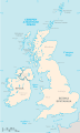
| BeschrijvingBritish Isles.svg |
An SVG map of the British Isles, with the largest islands and archipelagos labelled. |
||
| Bron | Eigen werk | ||
| Auteur | Smurrayinchester | ||
| SVG ontwikkeling InfoField | Deze niet W3C-deugdelijke kaart is gemaakt met een onbekende SVG-editor This map is translated using SVG switch elements: all translations are stored in the same file.
|
}
Licentie
Ik, de auteursrechthebbende van dit werk, maak het hierbij onder de volgende licentie beschikbaar:

|
Toestemming wordt verleend voor het kopiëren, verspreiden en/of wijzigen van dit document onder de voorwaarden van de GNU-licentie voor vrije documentatie, versie 1.2 of enige latere versie als gepubliceerd door de Free Software Foundation; zonder Invariant Sections, zonder Front-Cover Texts, en zonder Back-Cover Texts. Een kopie van de licentie is opgenomen in de sectie GNU-licentie voor vrije documentatie.http://www.gnu.org/copyleft/fdl.htmlGFDLGNU Free Documentation Licensetruetrue |
| Dit bestand is gelicenseerd onder de Creative Commons-licentie Naamsvermelding-Gelijk delen 3.0 Unported | ||
| ||
| Deze licentietag is toegevoegd aan dit bestand in verband met de GFDL licentie-update.http://creativecommons.org/licenses/by-sa/3.0/CC BY-SA 3.0Creative Commons Attribution-Share Alike 3.0truetrue |
Derivative works
-
 македонски
 -
 Flag map (1801–1922)


derivative works
Afgeleide werken van dit bestand: British Isles mk.svg
Bijschriften
Beschrijf in één regel wat dit bestand voorstelt
Items getoond in dit bestand
beeldt af
Waarde zonder Wikidata-item
image/svg+xml
e064d2a4d0614c9fef65714d82c69e5f314e2a45
157.654 byte
2.160 pixel
1.300 pixel
Bestandsgeschiedenis
Klik op een datum/tijd om het bestand te zien zoals het destijds was.
| Datum/tijd | Miniatuur | Afmetingen | Gebruiker | Opmerking | |
|---|---|---|---|---|---|
| huidige versie | 10 feb 2019 17:33 | | 1.300 × 2.160 (154 kB) | MSG17 | Uploaded from SVG Translate. |
| 13 okt 2018 16:56 |  | 1.300 × 2.160 (141 kB) | Seb35 | small bug: translations have to be before the default text else the PNG rendering selects the default text | |
| 13 okt 2018 16:51 |  | 1.300 × 2.160 (141 kB) | Seb35 | added French translation | |
| 20 mei 2014 16:50 |  | 1.300 × 2.160 (135 kB) | NikNaks | More cleaning. File could still be a lot smaller than it currently is | |
| 20 mei 2014 05:02 |  | 1.300 × 2.160 (152 kB) | NikNaks | Malay translation | |
| 20 mei 2014 04:36 |  | 1.300 × 2.160 (148 kB) | NikNaks | Cleaning unfortunately lost detail. Will have to return to later | |
| 20 mei 2014 04:22 |  | 1.297 × 2.160 (37 kB) | NikNaks | Attempting to clean up the file before translation | |
| 20 aug 2006 14:37 |  | 1.297 × 2.160 (196 kB) | Smurrayinchester | An SVG map of the British Isles, with the largest islands and archipelagos labeled. {{legend|#fff0de|Always considered part of the British Isles|border=#ffffff}} {{legend|#ffb380|Sometimes considered part of the British Isles|border=#ffffff}} {{legend|#e |
Bestandsgebruik
Dit bestand wordt op de volgende pagina gebruikt:
Globaal bestandsgebruik
De volgende andere wiki's gebruiken dit bestand:
- Gebruikt op ar.wikipedia.org
- Gebruikt op az.wikipedia.org
- Gebruikt op be.wikipedia.org
- Gebruikt op bs.wikipedia.org
- Gebruikt op ceb.wikipedia.org
- Gebruikt op ckb.wikipedia.org
- Gebruikt op da.wikipedia.org
- Gebruikt op en.wikipedia.org
- Geography of the Isle of Man
- Burhou
- Talk:International Football Association Board
- Module:Location map/data/British Isles/doc
- List of offshore wind farms in the Irish Sea
- Siege of St Andrews Castle
- User:Malpass93/sandbox
- Module:Location map/data/British Isles
- 2014 Senior Open Championship
- 2017 Senior Open Championship
- 2018 Eisenhower Trophy
- User:Grover cleveland/History of the laws of the game/List of IFAB meetings
- User:Grover cleveland/English managers
- 2018 Espirito Santo Trophy
- 1965 European Amateur Team Championship
- 1975 European Amateur Team Championship
- 1981 European Amateur Team Championship
- 1989 European Amateur Team Championship
- 1997 European Amateur Team Championship
- 2005 European Amateur Team Championship
- 2007 European Amateur Team Championship
- 2009 European Amateur Team Championship
- 1971 European Ladies' Team Championship
- 1979 European Ladies' Team Championship
- 1987 European Ladies' Team Championship
- 1991 European Ladies' Team Championship
- 2013 European Ladies' Team Championship
- 2021 European Ladies' Team Championship
- 2022 European Amateur Team Championship
- 2022 European Ladies' Team Championship
- 2013 Senior Open Championship
- 2012 Senior Open Championship
- 2011 Senior Open Championship
- 2008 Senior Open Championship
- 2006 Senior Open Championship
- 2002 Senior British Open
- 2001 Senior British Open
- 2000 Senior British Open
- 2022 Senior Open Championship
- User:Erik Sergeant/sandbox 2
- 2023 Senior Open Championship
- Module:Location map/data/British Isles/sandbox
- Draft:2024 Monoposto Championship
Globaal gebruik van dit bestand bekijken.
Metadata
Dit bestand bevat metadata met EXIF-informatie, die door een fotocamera, scanner of fotobewerkingsprogramma toegevoegd kan zijn.
| Breedte | 1300 |
|---|---|
| Hoogte | 2160 |
Overgenomen van "https://nl.wikipedia.org/wiki/Bestand:British_Isles.svg"