Bestand:Czechoslovakia01.png
Uit Wikipedia, de vrije encyclopedia
Grootte van deze voorvertoning: 800 × 340 pixels. Andere resoluties: 320 × 136 pixels | 1.100 × 468 pixels.
Oorspronkelijk bestand (1.100 × 468 pixels, bestandsgrootte: 63 kB, MIME-type: image/png)
| Dit is een bestand van Wikimedia Commons. Onderstaande beschrijving komt van de beschrijving van het bestand daar. |
Beschrijving
| BeschrijvingCzechoslovakia01.png |
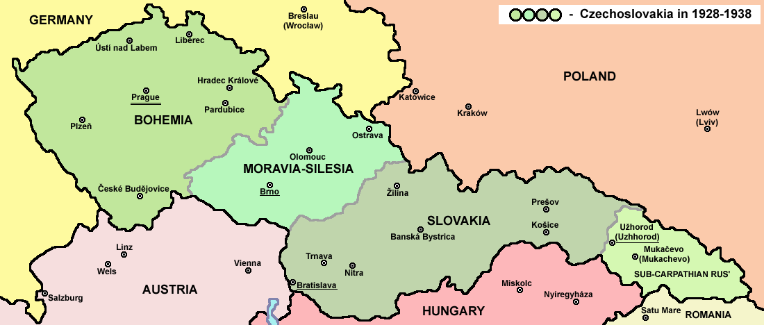
English: Map of Czechoslovakia in 1928-1938. Note: The provinces shown on the map were introduced by Act No. 125/1927 Zb. and became effective in 1928. Deutsch: Karte der Tschechoslowakei zwischen 1928 und 1938. |
|||
| Datum | ||||
| Bron |
Eigen werk Main reference:
Secondary references with similar maps:
Secondary references about Geo-political situation - published sources:
Secondary reference about sizable cities: |
|||
| Auteur |
PANONIAN
|
|||
| Toestemming (Hergebruik van dit bestand) |
|
|||
| Andere versies |
Afgeleide werken van dit bestand: |


|
Deze kaartafbeelding zou opnieuw moeten worden aangemaakt als een SVG-bestand door vectorafbeeldingen te gebruiken. Dit heeft een aantal voordelen; zie Commons:Media for cleanup voor meer informatie. Als er een SVG-formaat van deze afbeelding bestaat, dan deze graag uploaden. Nadat u dit heeft gedaan, gelieve dit sjabloon te vervangen door het sjabloon {{vector version available|nieuwe bestandsnaam.svg}} op deze afbeeldingspagina.
|
De productie, bewerking of vrijgave van dit bestand werd ondersteund door het Gemeenschapsbudget van Wikimedia Duitsland. Om andere bestanden te zien die gemaakt zijn met de steun van Wikimedia Duitsland, zie de categorie Supported by Wikimedia Deutschland. العربية ∙ বাংলা ∙ Deutsch ∙ English ∙ Esperanto ∙ français ∙ magyar ∙ Bahasa Indonesia ∙ italiano ∙ 日本語 ∙ македонски ∙ മലയാളം ∙ Bahasa Melayu ∙ Nederlands ∙ português ∙ русский ∙ slovenščina ∙ svenska ∙ українська ∙ தமிழ் ∙ +/−
|
Bijschriften
Beschrijf in één regel wat dit bestand voorstelt
Items getoond in dit bestand
beeldt af
Waarde zonder Wikidata-item
image/png
bd003d1960e9404724758c8fa7f85ee852d01738
64.020 byte
468 pixel
1.100 pixel
Bestandsgeschiedenis
Klik op een datum/tijd om het bestand te zien zoals het destijds was.
| Datum/tijd | Miniatuur | Afmetingen | Gebruiker | Opmerking | |
|---|---|---|---|---|---|
| huidige versie | 12 jul 2022 16:48 | | 1.100 × 468 (63 kB) | Sebastian Wallroth | cropped |
| 19 mei 2011 12:54 |  | 1.128 × 513 (63 kB) | PANONIAN | minor change, marked provincial capitals | |
| 17 mei 2011 11:53 |  | 1.128 × 513 (62 kB) | PANONIAN | Reverted to version as of 10:38, 24 April 2011 - because this is map of Czechoslovakia and it was capital of Czechoslovakia | |
| 17 mei 2011 07:07 |  | 1.128 × 513 (55 kB) | Millenium187 | Why was Prague underlined and Vienna, Brno, Bratislava and other capital cities were not? -- corrected | |
| 24 apr 2011 12:38 |  | 1.128 × 513 (62 kB) | PANONIAN | few corrections | |
| 23 apr 2011 13:31 |  | 1.128 × 509 (61 kB) | PANONIAN | improved version | |
| 20 dec 2008 22:58 |  | 1.100 × 497 (78 kB) | Kirk979 | {{Information |Description= |Source= |Date= |Author= |Permission= |other_versions= }} | |
| 28 dec 2006 18:11 |  | 1.100 × 497 (90 kB) | Electionworld | {{ew|en|PANONIAN}} Map of {{link|Czechoslovakia}} (self made) Note: The provinces shown on the map were introduced by Act No. 125/1927 Zb. and became effective in 1928. {{PD-self}} Category:Maps of Czechoslovakia Category:Maps of Czech history |
Bestandsgebruik
Dit bestand wordt op de volgende 3 pagina's gebruikt:
Globaal bestandsgebruik
De volgende andere wiki's gebruiken dit bestand:
- Gebruikt op af.wikipedia.org
- Gebruikt op als.wikipedia.org
- Gebruikt op ang.wikipedia.org
- Gebruikt op an.wikipedia.org
- Gebruikt op ar.wikipedia.org
- Gebruikt op arz.wikipedia.org
- Gebruikt op azb.wikipedia.org
- Gebruikt op az.wikipedia.org
- Gebruikt op bar.wikipedia.org
- Gebruikt op ba.wikipedia.org
- Gebruikt op bcl.wikipedia.org
- Gebruikt op be-tarask.wikipedia.org
- Gebruikt op be.wikipedia.org
- Gebruikt op bg.wikipedia.org
- Gebruikt op bn.wikipedia.org
- Gebruikt op br.wikipedia.org
- Gebruikt op ca.wikipedia.org
- Gebruikt op cs.wikipedia.org
- Gebruikt op cv.wikipedia.org
- Gebruikt op cy.wikipedia.org
- Gebruikt op de.wikipedia.org
- Gebruikt op diq.wikipedia.org
- Gebruikt op dsb.wikipedia.org
- Gebruikt op el.wikipedia.org
- Gebruikt op en.wikipedia.org
Globaal gebruik van dit bestand bekijken.
Metadata
Dit bestand bevat metadata met EXIF-informatie, die door een fotocamera, scanner of fotobewerkingsprogramma toegevoegd kan zijn.
| Horizontale resolutie | 28,35 dpc |
|---|---|
| Verticale resolutie | 28,35 dpc |
Overgenomen van "https://nl.wikipedia.org/wiki/Bestand:Czechoslovakia01.png"