Bestand:SaintMartinIle.PNG
Uit Wikipedia, de vrije encyclopedia
Geen hogere resolutie beschikbaar.
SaintMartinIle.PNG (250 × 115 pixels, bestandsgrootte: 7 kB, MIME-type: image/png)
| Dit is een bestand van Wikimedia Commons. Onderstaande beschrijving komt van de beschrijving van het bestand daar. |
| BeschrijvingSaintMartinIle.PNG |
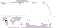
English: Localisation map of the Saint Martin island (France ; or Netherlands Antilles, Netherlands).
Français : Carte de localisation de l’île de Saint-Martin (France ; ou Antilles néerlandaises, Pays-Bas). |
|||
| Bron | à partir d'une carte du CIA WordFactBook | |||
| Auteur | Rémih | |||
| Toestemming (Hergebruik van dit bestand) |
|
Bijschriften
Beschrijf in één regel wat dit bestand voorstelt
Items getoond in dit bestand
beeldt af
Waarde zonder Wikidata-item
Bestandsgeschiedenis
Klik op een datum/tijd om het bestand te zien zoals het destijds was.
| Datum/tijd | Miniatuur | Afmetingen | Gebruiker | Opmerking | |
|---|---|---|---|---|---|
| huidige versie | 9 aug 2006 11:23 | | 250 × 115 (7 kB) | Rémih | *Description:Carte de localisation de Saint-Martin, Antilles néerlandaises, Pays-Bas *Auteur:Rémih à partir d'une carte du CIA WordFactBook category:Netherlands Antilles |
Bestandsgebruik
Dit bestand wordt op de volgende 4 pagina's gebruikt:
Globaal bestandsgebruik
De volgende andere wiki's gebruiken dit bestand:
- Gebruikt op es.wikipedia.org
- Gebruikt op fr.wikipedia.org
- Gebruikt op hu.wikipedia.org
- Gebruikt op oc.wikipedia.org
- Gebruikt op pl.wiktionary.org
- Gebruikt op uk.wikipedia.org
Overgenomen van "https://nl.wikipedia.org/wiki/Bestand:SaintMartinIle.PNG"