File:Europe_1867_map_en.png
Uit Wikipedia, de vrije encyclopedia
Grootte van deze voorvertoning: 800 × 526 pixels. Andere resoluties: 320 × 211 pixels | 640 × 421 pixels | 1.024 × 674 pixels | 1.280 × 842 pixels | 2.284 × 1.503 pixels.
Oorspronkelijk bestand (2.284 × 1.503 pixels, bestandsgrootte: 1,07 MB, MIME-type: image/png)
| Dit is een bestand van Wikimedia Commons. Onderstaande beschrijving komt van de beschrijving van het bestand daar. |
Beschrijving
| BeschrijvingEurope 1867 map en.png |
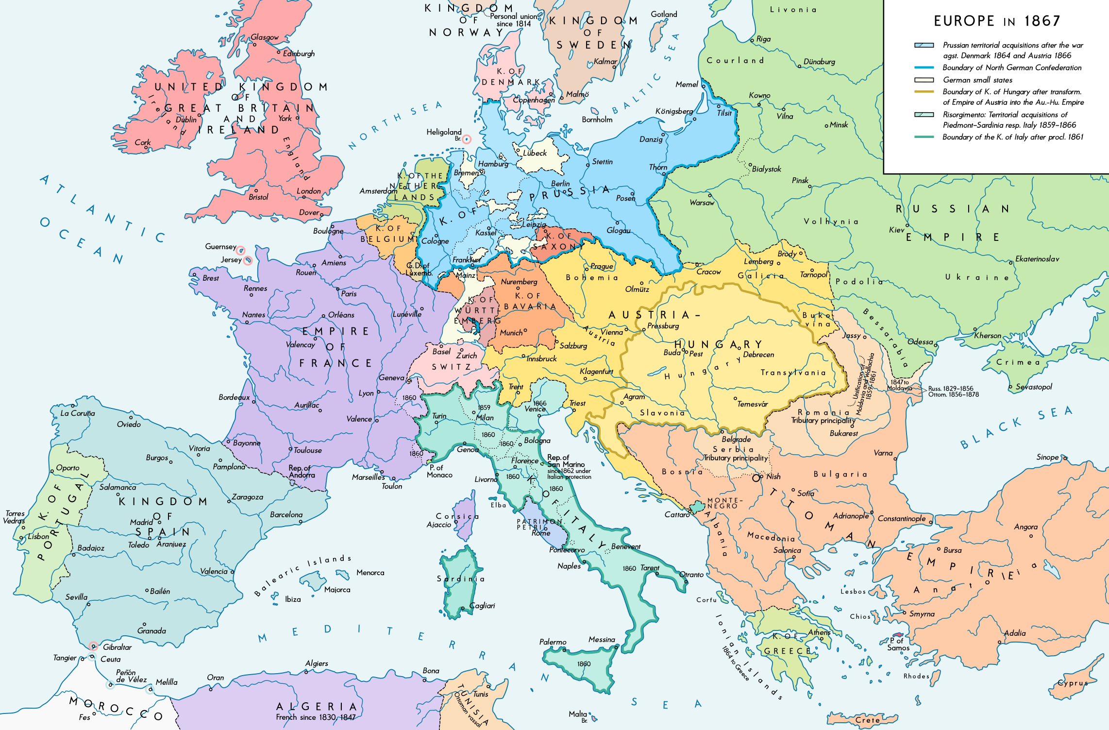
English: Europe 1867. Historical map of the political situation after the forming of the North German Confederation, the Italian Risorgimento (with the exception of the Roman part of the Papal States) and the Austro-Hungarian Compromise of 1867. Please don't alter the map, when you think there something not written or depicted correctly. Leave a message at the talk page of the file. After a verificiation and a possible discussion, i will upload a new map version with all new changes. This prevents an unnecessary waste of disc space and ensures a good result, aesthetically and contentwise. - The author. Deutsch: Europa 1867. Historische Karte der politischen Situation in Europa nach der Gründung des Norddeutschen Bundes, des italienischen Risorgimento (mit Ausnahme des röm. Teils des Kirchenstaats) und dem Österreichisch-Ungarischen Ausgleich von 1867. Bitte die Karte bei Änderungs- und Korrekturwünschen nicht selbst verändern, sondern eine Anmerkung im Diskussionsbereich der Bilddatei hinterlassen. Nach einer Prüfung und ggfs. Diskussion werden evtl. Änderungen von mir zusammengefasst eingearbeitet. Das vermeidet unnötige Speicherplatz-Verschwendung und gewährleistet ein ästhetisch ansprechendes und inhaltlich korrektes Ergebnis. - Der Urheber. |
| Datum | |
| Bron |
Eigen werk. Source of Information: Historical atlases and maps – Ramsay Muir, George Philip (ed.): Philip's New School Atlas of Universal History, George Philip & Son, Ltd., London 1928 – Dr. Walter Leisering (ed.): Putzger Historischer Weltatlas, Cornelsen Verlag, Berlin 1992, ISBN 3-464-00176-8 – Bayerischer Schulbuch-Verlag (ed.): Großer Historischer Weltatlas, Dritter Teil, Neuzeit, Bayerischer Schulbuch-Verlag, München 1981, ISBN 3-7627-6021-7. – Prof. Dr. Vadim Oswalt u. Prof. Dr. Hans Ulrich Rudolf (ed.): Klett-Perthes Atlas zur Weltgeschichte, Ernst Klett Verlag, Stuttgart 2011, ISBN 978-3-12-828194-0 – Ziegelbrenner: Karte des Norddeutschen Bundes 1866–1871, 6 June 2014 version (map link) Other publications – Francesco Traniello u. Gianni Sofri: Der lange Weg zur Nation. Das italienische Risorgimento, Verlag W. Kohlhammer, Stuttgart 2012, ISBN 978-3-17-021898-7 |
| Auteur | Alexander Altenhof |
| Andere versies |
|

Recompressed without quality loss with OptiPNG (1.35 MB > 1.06 MB)
Licentie
Ik, de auteursrechthebbende van dit werk, maak het hierbij onder de volgende licentie beschikbaar:
Dit bestand is gelicenseerd onder de Creative Commons Naamsvermelding-GelijkDelen 4.0 Internationaal licentie.
- De gebruiker mag:
- Delen – het werk kopiëren, verspreiden en doorgeven
- Remixen – afgeleide werken maken
- Onder de volgende voorwaarden:
- naamsvermelding – U moet op een gepaste manier aan naamsvermelding doen, een link naar de licentie geven, en aangeven of er wijzigingen in het werk zijn aangebracht. U mag dit op elke redelijke manier doen, maar niet zodanig dat de indruk wordt gewekt dat de licentiegever instemt met uw werk of uw gebruik van zijn werk.
- Gelijk delen – Als u het werk heeft geremixt, veranderd, of erop heeft voortgebouwd, moet u het gewijzigde materiaal verspreiden onder dezelfde licentie als het oorspronkelijke werk, of een daarmee compatibele licentie.
Bijschriften
Beschrijf in één regel wat dit bestand voorstelt
Items getoond in dit bestand
beeldt af
Waarde zonder Wikidata-item
4 sep 2016
Bestandsgeschiedenis
Klik op een datum/tijd om het bestand te zien zoals het destijds was.
| Datum/tijd | Miniatuur | Afmetingen | Gebruiker | Opmerking | |
|---|---|---|---|---|---|
| huidige versie | 15 apr 2017 01:42 | | 2.284 × 1.503 (1,07 MB) | KaterBegemot | Empire of France (not Kingdom), changed main caption to "Europe in 1867", fixed font size of "Piedmont-Sardinia", minor changes |
| 4 sep 2016 23:36 |  | 2.284 × 1.503 (1,06 MB) | KaterBegemot | {{Information |Description ={{en|1=Europe 1867. Historical map of the political situation after the forming of the North German Confederation, the Italian Risorgimento (with the exception of the Roman part of the Papal States) and the Austro-Hungari... |
Bestandsgebruik
Geen enkele pagina gebruikt dit bestand.
Globaal bestandsgebruik
De volgende andere wiki's gebruiken dit bestand:
- Gebruikt op ast.wikipedia.org
- Gebruikt op en.wikipedia.org
- Gebruikt op et.wikipedia.org
- Gebruikt op it.wikipedia.org
Metadata
Dit bestand bevat metadata met EXIF-informatie, die door een fotocamera, scanner of fotobewerkingsprogramma toegevoegd kan zijn.
| Gebruikte software | Adobe Photoshop CC 2017 (Windows) |
|---|---|
| Horizontale resolutie | 70 dpi |
| Verticale resolutie | 70 dpi |
| Kleurruimte | Ongekalibreerd |
| Afbeeldingsbreedte | 2.284 px |
| Afbeeldingshoogte | 1.503 px |
| Tijdstip digitalisering | 15 apr 2017 03:05 |
| Tijdstip laatste bestandswijziging | 15 apr 2017 03:22 |
| Datum waarop de metadata het laatst zijn bewerkt | 15 apr 2017 03:22 |
| Uniek ID van het originele document | xmp.did:fd41fa5f-5199-fd40-bec6-d1a7668cc651 |
Overgenomen van "https://nl.wikipedia.org/wiki/Bestand:Europe_1867_map_en.png"