File:Wirral_peninsula_satellite.png
Uit Wikipedia, de vrije encyclopedia
Geen hogere resolutie beschikbaar.
Wirral_peninsula_satellite.png (400 × 400 pixels, bestandsgrootte: 299 kB, MIME-type: image/png)
| Dit is een bestand van Wikimedia Commons. Onderstaande beschrijving komt van de beschrijving van het bestand daar. |
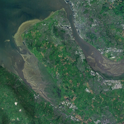
| BeschrijvingWirral peninsula satellite.png | A satellite photograph of the Wirral Peninsula (centre), showing the River Mersey and its estuary to the east, Liverpool Bay to the north and River Dee in the west across from the coast of Flintshire in Wales. |
| Datum | |
| Bron | NASA World Wind - Landsat 7 |
| Auteur | Smurrayinchester |
| Public domainPublic domainfalsefalse |
| Deze afbeelding bevindt zich in het publiek domein omdat het een screenshot is van NASA’s software World Wind die gebruik maakt van een publiek domein-laag, zoals Blue Marble, MODIS, Landsat, SRTM, USGS of GLOBE.
العربيَّة | English | فارسی | français | עברית | македонски | മലയാളം | Nederlands | русский | 中文(中国大陆) | +/− |
 |
| Cameralocatie | 53° 30′ 00″ NB, 3° 23′ 24″ WL | Deze en andere afbeeldingen in: OpenStreetMap |
|---|
Dit bestand is geëxtraheerd uit een ander bestand : Liverpool Bay.png |
 |
Bijschriften
Beschrijf in één regel wat dit bestand voorstelt
Items getoond in dit bestand
beeldt af
28 apr 2007
53°30'0"N, 3°23'24"W
image/png
Bestandsgeschiedenis
Klik op een datum/tijd om het bestand te zien zoals het destijds was.
| Datum/tijd | Miniatuur | Afmetingen | Gebruiker | Opmerking | |
|---|---|---|---|---|---|
| huidige versie | 29 aug 2022 22:33 | | 400 × 400 (299 kB) | DankJae | File:Liverpool Bay.png cropped 69 % horizontally, 58 % vertically using CropTool with precise mode. |
Bestandsgebruik
Geen enkele pagina gebruikt dit bestand.
Globaal bestandsgebruik
De volgende andere wiki's gebruiken dit bestand:
- Gebruikt op cy.wikipedia.org
- Gebruikt op en.wikipedia.org
Metadata
Dit bestand bevat metadata met EXIF-informatie, die door een fotocamera, scanner of fotobewerkingsprogramma toegevoegd kan zijn.
| Tijdstip laatste bestandswijziging | 29 aug 2022 20:31 |
|---|
Overgenomen van "https://nl.wikipedia.org/wiki/Bestand:Wirral_peninsula_satellite.png"