File:California_map_showing_Kern_County.png
From Wikipedia, the free encyclopedia
- Simpan (File)
- Amlat ning simpan (File history)
- ↓Suglung kareng simpan (''file links'')
- Global file usage
Ala nang mas malino pa.
California_map_showing_Kern_County.png (200 × 231 pixel, sukad ning simpan: 22 KB, MIME type: image/png)
This file is from Wikimedia Commons and may be used by other projects. The description on its file description page there is shown below.
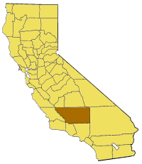
Map of Kern county in California. From en:

|
Permission is granted to copy, distribute and/or modify this document under the terms of the GNU Free Documentation License, Version 1.2 or any later version published by the Free Software Foundation; with no Invariant Sections, no Front-Cover Texts, and no Back-Cover Texts. A copy of the license is included in the section entitled GNU Free Documentation License.http://www.gnu.org/copyleft/fdl.htmlGFDLGNU Free Documentation Licensetruetrue |
| This file is licensed under the Creative Commons Attribution-Share Alike 3.0 Unported license. | ||
| ||
| This licensing tag was added to this file as part of the GFDL licensing update.http://creativecommons.org/licenses/by-sa/3.0/CC BY-SA 3.0Creative Commons Attribution-Share Alike 3.0truetrue |
Captions
Add a one-line explanation of what this file represents
Items portrayed in this file
depicts English
copyright status English
copyrighted English
media type English
image/png
checksum English
410baf5891fe6c726e86f69c3abd8f27b8377e6e
data size English
22,733 byte
height English
231 pixel
width English
200 pixel
Amlat ning simpan (File history)
Mag-click kang petsa/oras ba meng akit ing itsura ning simpan aniang panaun a ita.
| Petsa/Oras | Thumbnail | Sukad | Talagamit | Komentu/Puna | |
|---|---|---|---|---|---|
| salukuyan | 17:03, 1 Juliu 2005 | | 200 × 231 (22 KB) | Pyramide~commonswiki | Map of Kern county in California. From en: {{GFDL}} Category:Maps of counties in California |
↓Suglung kareng simpan (''file links'')
Ing tutuking page links kaniting simpan (file):
Global file usage
The following other wikis use this file:
- Usage on bg.wikipedia.org
- Usage on en.wikipedia.org
- Brown Peak (Kern County, California)
- Wonder Acres, Kern County, California
- Cache Creek (Kern County, California)
- Lost Hills
- Bear Mountain (Kern County, California)
- Edwards, California
- Keyesville, California
- Cantil, California
- Honda Proving Center of California
- Locarno Mine
- El Paso Mountains Wilderness
- Garlock, California
- Indian Wells (Kern County, California)
- Rand Mountains
- Fremont Valley
- Desert Tortoise Natural Area
- El Paso Mountains
- Scodie Mountains
- Greenhorn Mountains
- Jawbone–Butterbredt Area of Critical Environmental Concern
- Willow Springs, Kern County, California
- Famoso, California
- Walker Basin
- Template:KernCountyCA-geo-stub
- White Wolf Fault
- San Emigdio Mountain
- Sawmill Mountain
- Cerro Noroeste
- Grouse Mountain (California)
- Brush Mountain (Kern County, California)
- Cummings Mountain (California)
- Independence dike swarm
- Bealville, California
- Antimony Peak
- Eagle Rest Peak
- Tecuya Mountain
- South Lake, Kern County, California
- Edison, California
- Antelope Hills, California
- Bacon Hills
- Bissell Hills
- Black Hills (Kern County)
- Buena Vista Hills (Kern County)
- Elk Hills
- Horned Toad Hills
- Little Signal Hills
- Pleito Hills
- Rosamond Hills
- Shale Hills
View more global usage of this file.