File:Claude_Bernou_Carte_de_lAmerique_septentrionale.jpg
維基百科,自由的 encyclopedia
本预览的尺寸:632 × 599像素。 其他分辨率:253 × 240像素 | 506 × 480像素 | 810 × 768像素 | 1,080 × 1,024像素 | 2,161 × 2,048像素 | 3,841 × 3,641像素。
原始文件 (3,841 × 3,641像素,文件大小:5.86 MB,MIME类型:image/jpeg)
摘要
| 描写Claude Bernou Carte de lAmerique septentrionale.jpg |
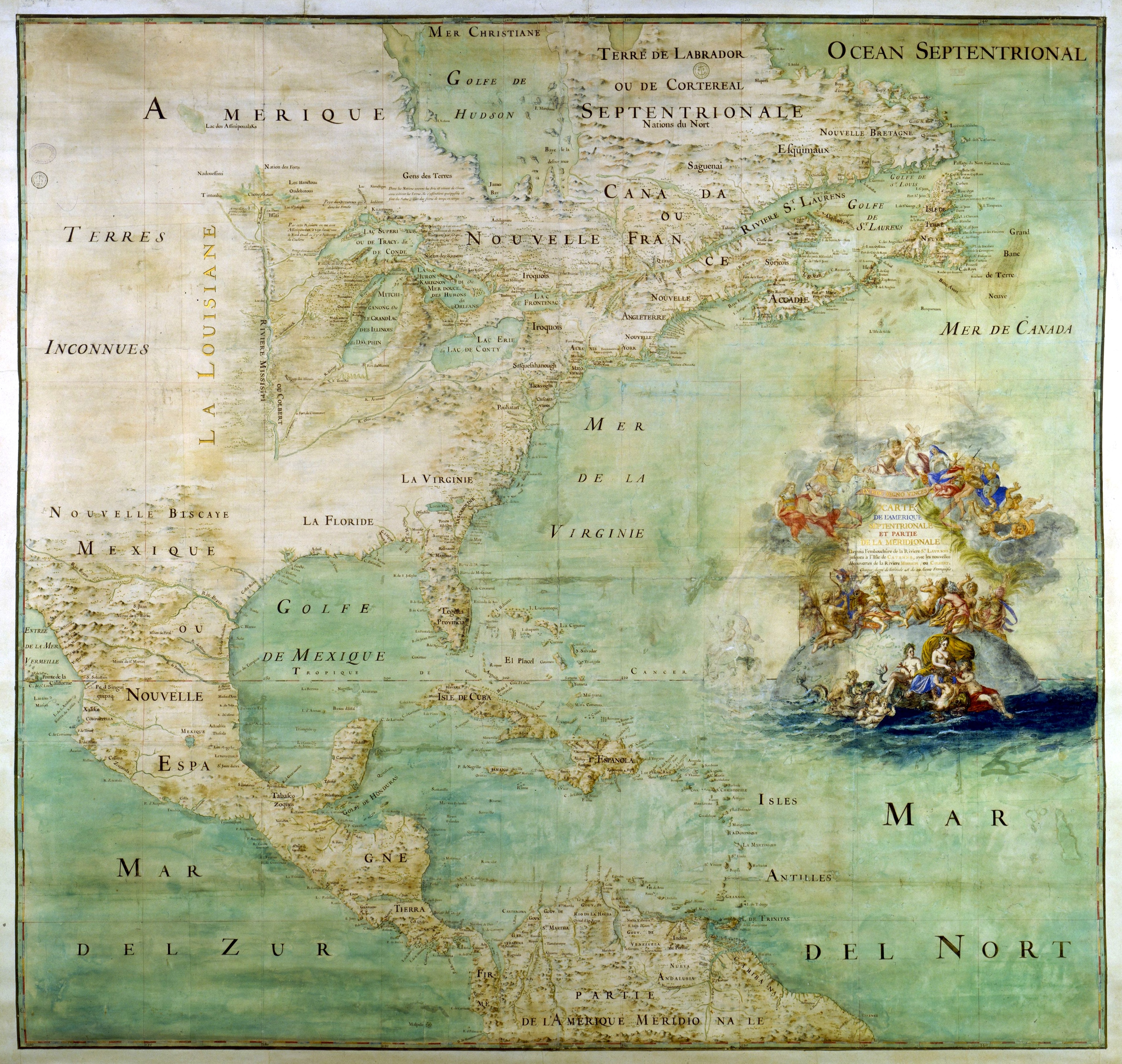
English: Map of the northern part and parts of the southern parts of the America, from the mouth of the Saint Laurent River to the Island of Cayenne,with the new discoveries of the Mississipi (or Colbert) River. This map shows the results of the expeditions of Father Marquette and L. Jolliet (1673) and the Cavelier de la Salle expedition in the Mississipi valley. The map shows three forts built between 1679 and 1680: Conty fort (near Niagara Falls), Miamis Fort (south of Michigan lake), and Crèvecœur fort (Left bank of the Illinois River). Mississippi river course is only shown upstream of Ohio confluence.
Français : Carte de l'Amérique septentrionale et partie de la méridionale depuis l'embouchure de la rivière St Laurens jusqu'à l'isle de Cayenne avec les nouvelles découvertes de la rivière de Mississipi ou Colbert [attribuée à l'abbé Bernou]. Montre le résultat des expéditions du is (au sud du Lac Michigan), fort Crèvecœur (rive gauche de l'Illinois). Le cours du Mississippi n'est figuré que jusqu'à sa confluence avec l'Ohio. Collation : 1 carte, ms. col. , 163 × 147 cm
Čeština: Mapa severní části a částí jižních částí Ameriky, od ústí řeky Saint Laurent po ostrov Cayenne, s novými objevy řeky Mississipi (neboli Colbert). Tato mapa ukazuje výsledky expedic otce Marquette a L. Jolliet (1673) a expedice Cavelier de la Salle v údolí Mississipi. Mapa ukazuje tři pevnosti postavené v letech 1679 až 1680: pevnost Conty (poblíž Niagarských vodopádů), pevnost Miamis (jižně od Michiganského jezera) a pevnost Crèvecœur (levý břeh řeky Illinois). Kurz řeky Mississippi je zobrazen pouze před soutokem s řekou Ohio. |
| 日期 |
约1681年 date QS:P,+1681-00-00T00:00:00Z/9,P1480,Q5727902 |
| 来源 | Uploaded by David.Monniaux |
| 創作作者 |
Bernou, Claude (b. 16..–d. 17..), Abbot |
| 地理参考 | 地理参考Wikimaps Warper中的地图 如果不适当,请设置 warp_status = skip 为隐藏。 |
本图像被选为2006年3月22日的今日图片。其说明如下: English: Early map of North America 其他语言:
Alemannisch: Alti Kart vun Nordamerika Čeština: Mapa Severní Ameriky ze 17. století. Deutsch: Frühe Karte von Nordamerika English: Early map of North America Español: Antiguo mapa de América del Norte Français : Ancienne carte de l'Amérique du nord Galego: mapa de America do Norte Italiano: Antica mappa dell'America del Nord Lëtzebuergesch: Historesch Kaart vun Nordamerika. Magyar: Észak-Amerika XVII. századi térképe Norsk nynorsk: Tidleg kart over Nord-Amerika. Polski: Siedemnastowieczna mapa Ameryki Północnej Português: Mapa antigo da América do Norte Suomi: Vanha Pohjois-Amerikan kartta. Български: Ранна карта на Северна Америка (17 век) Русский: Древняя карта Северной Америки 日本語: 初期の北アメリカの地図 中文: 北美17世纪时的地图。 |
许可协议
本图像属于公有领域。因为它是纯粹扫描或影印自一个已处于公有领域的原件或类似的预期不会受到版权保护的扫描或影印件。其原件因以下原因处于公有领域:
本标签主要用于该扫描件有可能使用任何增强功能(如亮度、对比度、色彩调整、锐利化等),而这些增强功能无法达到原创性而无法产生版权的情形下使用。而该标签也能使用在无法判定本扫描件使用任何增强功能,以及已知使用增强功能但没有充分证据时。对于采取原始忠实扫描而不使用增强功能的照片,可以适当采用{{PD-old}}标签取代。对于本标签的使用方法,参见共享资源:何时使用PD-Scan标签。  | |||||
说明
添加一行文字以描述该文件所表现的内容
Carte de l'Amérique septentrionale et partie de la méridionale depuis l'embouchure de la rivière St Laurens jusqu'à l'isle de Cayenne avec les nouvelles découvertes de la rivière de Mississipi ou Colbert. 163 × 147 cm
共享资源质量评价 简体中文(已转写)
image/jpeg
6,140,476 字节
3,641 像素
3,841 像素
文件历史
点击某个日期/时间查看对应时刻的文件。
| 日期/时间 | 缩略图 | 大小 | 用户 | 备注 | |
|---|---|---|---|---|---|
| 当前 | 2012年6月29日 (五) 14:13 | | 3,841 × 3,641(5.86 MB) | Paris 16 | cropped |
| 2005年5月15日 (日) 20:12 |  | 3,946 × 3,697(6.2 MB) | David.Monniaux | ||
| 2005年5月15日 (日) 18:23 |  | 3,792 × 3,576(5.89 MB) | David.Monniaux | {{Français}} '''Auteur :''' Bernou, Claude (16..-17..?), abbé '''Titre :''' ''Carte de l'Amérique septentrionale et partie de la méridionale depuis l'embouchure de la rivière St Laurens jusqu'à l'isle de Cayenne avec les nouvelles décou |
文件用途
以下页面使用本文件:
全域文件用途
以下其他wiki使用此文件:
- af.wikipedia.org上的用途
- ar.wikipedia.org上的用途
- azb.wikipedia.org上的用途
- az.wikipedia.org上的用途
- br.wikipedia.org上的用途
- ca.wikipedia.org上的用途
- cs.wikipedia.org上的用途
- de.wikipedia.org上的用途
- en.wikipedia.org上的用途
- New France
- Médard des Groseilliers
- Illinois Country
- Louisiana (New France)
- Spanish Texas
- Timeline of the European colonization of North America
- User:Cliché Online/New France
- French colonization of Texas
- Portal:Maps/Maps/Historical
- Portal:Maps/Maps/Historical/12
- Fort Crevecoeur
- List of French possessions and colonies
- Cartography of the United States
- Timeline of European imperialism
- Wikipedia:Featured picture candidates/Bernou's map of Nothern America
- Wikipedia:Featured picture candidates/March-2017
- Fort Saint-Louis (Texas)
- User:Falcaorib/Canada, United States and Mexico
- eo.wikipedia.org上的用途
- es.wikipedia.org上的用途
查看此文件的更多全域用途。
元数据
此文件中包含有扩展的信息。这些信息可能是由数码相机或扫描仪在创建或数字化过程中所添加。
如果此文件的源文件已经被修改,一些信息在修改后的文件中将不能完全反映出来。
| 方向 | 标准 |
|---|---|
| 水平分辨率 | 72 dpi |
| 垂直分辨率 | 72 dpi |