চিত্ৰ:Outre-mer_en.png
From Wikipedia, the free encyclopedia
এই খচৰাৰ আকাৰ: 800 × 400 পিক্সেল. আন ৰিজ'লিউশ্যনসমূহ: 320 × 160 পিক্সেল | 640 × 320 পিক্সেল | 1,480 × 740 পিক্সেল।
মূল ফাইল (1,480 × 740 পিক্সেল, ফাইলৰ মাত্ৰা: 54 KB, MIME প্ৰকাৰ: image/png)
| এই ফাইলটো ৱিকিমিডিয়া কমন্সৰ পৰা আমদানি কৰা হৈছে। ফাইল বিৱৰণ পৃষ্ঠাৰ সবিশেষ তথ্য তলত উল্লেখ কৰা হ’ল ।
|
সাৰাংশ
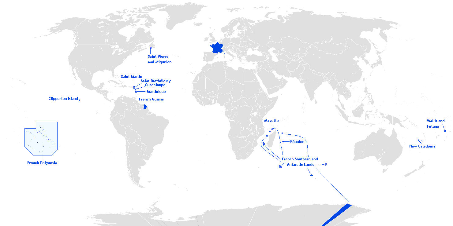
English: This is a translation from esperanto (by Hoshie) into english of User:Manchot sanguinaire's map of French Overseas départements, regions, collectivités, and territories, which is at Image:Outre-mer eo.png. The translations of the names into english are the names used in the CIA World Factbook. I also also added the five Îles Éparses that surround Madagascar. The source for their placement on the map is the CIA Factbook map of the area, which is here on Commons at Image:Iles Eparses-CIA WFB Map.png. The placement of Adélie Land is based upon Image:Antarctica territorial claims.png by User:Astrokey44. Since the original map is GFDL, this one is too.

|
This locator map image could be re-created using vector graphics as an SVG file. This has several advantages; see Commons:Media for cleanup for more information. If an SVG form of this image is available, please upload it and afterwards replace this template with
{{vector version available|new image name}}.
It is recommended to name the SVG file “Outre-mer en.svg”—then the template Vector version available (or Vva) does not need the new image name parameter. |
অনুজ্ঞাপত্ৰ
Hoshie, এই কামৰ স্বত্বাধিকাৰী, ইয়াৰ দ্বাৰা এই কামক তলত বৰ্ননা দিয়া অনুজ্ঞাপত্ৰৰ অধীনত প্ৰকাশ কৰা হ’ল

|
GNU Free Documentation License ৰ চুক্তিসমূহৰ অন্তৰ্গত এই দস্তাবেজ কপি, বিতৰণ আৰু/অথবা সলনি কৰাৰ অনুমতি প্ৰদান কৰা হৈছে, সংস্কৰণ 1.2 অথবা Free Software Foundation দ্বাৰা প্ৰকাশ কৰা পিছৰ যিকোনো সংস্কৰণত; কোনো অপৰিবৰ্তনশীল অংশ, কোনো ফ্ৰন্ট-কভাৰ টেক্সট, আৰু কোনো বেক-কভাৰ টেক্সট নহোৱাকৈ। অনুজ্ঞাৰ এটা কপি GNU Free Documentation License নামৰ অংশত অন্তৰ্ভুক্ত কৰা হৈছে।http://www.gnu.org/copyleft/fdl.htmlGFDLGNU Free Documentation Licensetruetrue |
| এই ফাইলটো ক্ৰিয়েটিভ কমন্স এট্ৰিবইউচন-চেয়াৰ এলাইক ৩.০ আন্প'ৰ্টেড অনুজ্ঞাপত্ৰৰ অধীনত। | ||
| স্বীকৃতিপ্ৰদান: Hoshie | ||
| ||
| এই অনুজ্ঞা টেগ এই ফাইলত GFDL অনুজ্ঞা আপডেইট ৰ অংশ হিচাপে যোগ কৰা হৈছিল।http://creativecommons.org/licenses/by-sa/3.0/CC BY-SA 3.0Creative Commons Attribution-Share Alike 3.0truetrue |
কেপ্চন
এই ফাইলে কি প্ৰতিনিধিত্ব কৰে তাৰ এটা শাৰীত ব্যাখ্যা কৰক
Map of France's overseas possessions as of 2020
Fransız deniz aşırı toprakları
Items portrayed in this file
depicts ইংৰাজী
copyright status ইংৰাজী
copyrighted ইংৰাজী
ফাইলৰ ইতিবৃত্ত
ফাইলৰ আগৰ অৱস্থা চাবলৈ সেই তাৰিখ/সময়ত ক্লিক কৰক।
| তাৰিখ/সময় | ক্ষুদ্ৰ প্ৰতিকৃতি | আকাৰ | সদস্য | মন্তব্য | |
|---|---|---|---|---|---|
| বৰ্তমান | 20:27, 27 March 2018 | | 1,480 × 740 (54 KB) | Maphobbyist | Upload |
| 09:12, 28 February 2016 |  | 1,480 × 740 (54 KB) | Kontrollstellekundl | Polynesia colour | |
| 13:15, 24 July 2013 |  | 1,480 × 740 (44 KB) | DrKay | remove dark grey areas in Antartica, Dniestr, Kosovo, Palestine, etc. | |
| 20:41, 12 February 2012 |  | 1,480 × 740 (75 KB) | Spesh531 | +south sudan, antarctic territories, other lands, change color of land, fixed boudaries, added accents on e in R e union and Saint Barth e lemy, fixed islands in French Polynesia | |
| 03:12, 17 December 2007 |  | 1,432 × 742 (58 KB) | Rosss | More accurate shape for French Polynesia | |
| 02:44, 22 April 2007 |  | 1,432 × 742 (39 KB) | Kelvinc | fixed shading of antarctica east of adelie land | |
| 09:59, 17 April 2007 |  | 1,432 × 742 (26 KB) | Tene~commonswiki | Optimised (0) | |
| 14:14, 5 March 2007 |  | 1,432 × 742 (60 KB) | Hoshie | added Antarctica itself to the image and marked the French claim. The position of St.-Barth and St.-Martin has been fixed | |
| 18:26, 4 March 2007 |  | 1,357 × 628 (53 KB) | Hoshie | removed labels for the Iles Eparses, since they are a part of the TAAF; see http://www.taaf.fr/rubriques/iles/iles_introduction.htm | |
| 07:11, 2 March 2007 |  | 1,357 × 628 (54 KB) | Hoshie | fixed map to include St.-Martin and St.-Barth. |
ফাইল ব্যৱহাৰ
তলত দিয়া পৃষ্ঠাটোৱে এই ফাইলটো ব্যৱহাৰ কৰে:
ফাইলৰ গোলকীয় ব্যৱহাৰ
তলত দিয়া আন ৱিকিসমূহে এই ফাইলটো ব্যৱহাৰ কৰে:
- af.wikipedia.org-ৰ ব্যৱহাৰ
- ar.wikipedia.org-ৰ ব্যৱহাৰ
- az.wikipedia.org-ৰ ব্যৱহাৰ
- bcl.wikipedia.org-ৰ ব্যৱহাৰ
- be.wikipedia.org-ৰ ব্যৱহাৰ
- ca.wikipedia.org-ৰ ব্যৱহাৰ
- da.wikipedia.org-ৰ ব্যৱহাৰ
- de.wikipedia.org-ৰ ব্যৱহাৰ
- el.wikipedia.org-ৰ ব্যৱহাৰ
- en.wikipedia.org-ৰ ব্যৱহাৰ
- Portal:France/Geography
- Portal:France/Administrative divisions
- Template:Infobox European Parliament constituency
- Overseas Territories of France (European Parliament constituency)
- Template:Infobox European Parliament constituency/doc
- Overseas France
- Template:Infobox European Parliament constituency/sandbox
- eo.wikipedia.org-ৰ ব্যৱহাৰ
- es.wikipedia.org-ৰ ব্যৱহাৰ
- et.wikipedia.org-ৰ ব্যৱহাৰ
- eu.wikipedia.org-ৰ ব্যৱহাৰ
এই ফাইলটোৰ অধিক গোলকীয় ব্যৱহাৰ চাওক।
মেটাডেটা
এই ফাইলত অতিৰিক্ত খবৰ আছে, হয়তো ডিজিটেল কেমেৰা বা স্কেনাৰ ব্যৱহাৰ কৰি সৃষ্টি বা পৰিৱৰ্তন কৰা হৈছে ।
এই ফাইলটো আচলৰ পৰা পৰিৱৰ্তন কৰা হৈছে, সেয়েহে পৰিৱৰ্তিত ফাইলটোৰ সৈতে নিমিলিব পাৰে ।
| আনুভূমিক ৰিজ'লিউশ্যন | 37.8 dpc |
|---|---|
| উলম্বিক ৰিজ'লিউশ্যন | 37.8 dpc |
"https://as.wikipedia.org/wiki/চিত্ৰ:Outre-mer_en.png"ৰ পৰা অনা হৈছে