Fayl:Mars_Géolocalisation.jpg
From Wikipedia, the free encyclopedia
Faylın orijinalı (2.048 × 1.024 piksel, fayl həcmi: 1,55 MB, MIME növü: image/jpeg)
| Bu fayl "Vikimedia Commons"dadır və digər layihələrdə istifadə edilə bilər. |
 |
Faylın təsvir səhifəsinə get |
Xülasə
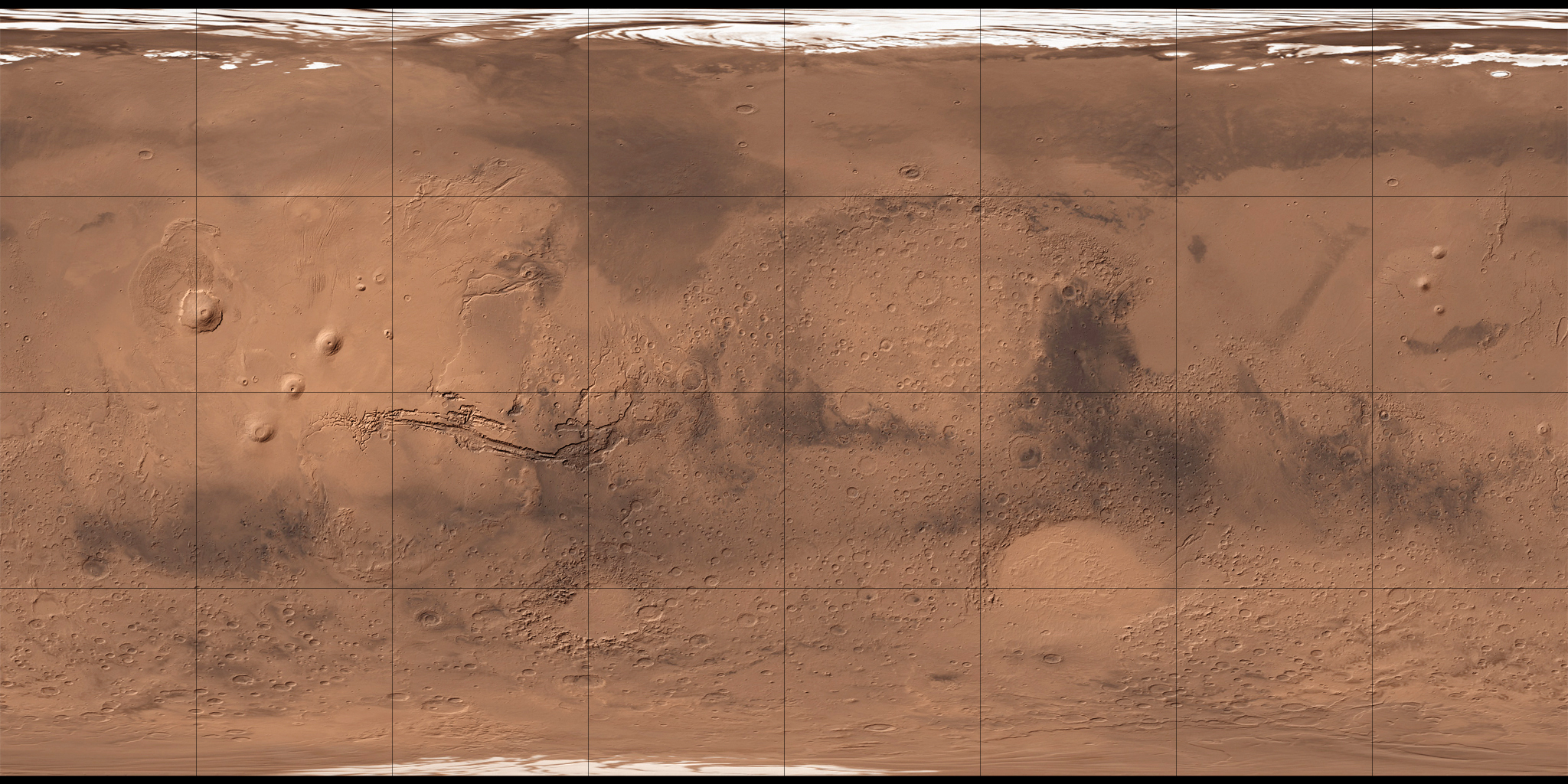
| İzahMars Géolocalisation.jpg |
Français : Carte de Mars reconstituée à partir des mesures de Mars Global Surveyor (MOLA) et des observations de Viking. |
|||
| Tarix | 2 avqust 2008 (upload date) | |||
| Mənbə | MOLA Shaded Relief & Viking. | |||
| Müəllif | NASA, USGS et Who killed Bambi ? pour les retouches. | |||
| Digər versiyalar |
|

Lisenziya
| Public domainPublic domainfalsefalse |
| This file is in the public domain in the United States because it was solely created by NASA. NASA copyright policy states that "NASA material is not protected by copyright unless noted". (See Template:PD-USGov, NASA copyright policy page or JPL Image Use Policy.) | ||
 |
Warnings:
|
| Public domainPublic domainfalsefalse |
This image is in the public domain in the United States because it only contains materials that originally came from the United States Geological Survey, an agency of the United States Department of the Interior. For more information, see the official USGS copyright policy.
Bahasa Indonesia ∙ català ∙ čeština ∙ Deutsch ∙ eesti ∙ English ∙ español ∙ français ∙ galego ∙ italiano ∙ Nederlands ∙ português ∙ polski ∙ sicilianu ∙ suomi ∙ Tiếng Việt ∙ Türkçe ∙ български ∙ македонски ∙ русский ∙ മലയാളം ∙ 한국어 ∙ 日本語 ∙ 中文 ∙ 中文(简体) ∙ 中文(繁體) ∙ العربية ∙ فارسی ∙ +/− |
| Annotations InfoField | This image is annotated: View the annotations at Commons |
Ophir Catenae
Captions
Items portrayed in this file
təsvir edir
2 avqust 2008
Faylın tarixçəsi
Faylın əvvəlki versiyasını görmək üçün gün/tarix bölməsindəki tarixlərə klikləyin.
| Tarix/Vaxt | Miniatür | Ölçülər | İstifadəçi | Şərh | |
|---|---|---|---|---|---|
| hal-hazırkı | 11:34, 2 avqust 2008 | | 2.048 × 1.024 (1,55 MB) | Who killed Bambi ? | {{Information |Description= |Source= |Date= |Author= |Permission= |other_versions= }} |
| 13:07, 27 iyul 2008 |  | 2.048 × 1.024 (1,96 MB) | Who killed Bambi ? | {{Information |Description={{fr|1=Carte de Mars reconstituée à partir des observations de Viking}} |Source=ftp://ftpflag.wr.usgs.gov/dist/pigpen/mars/usgs/mdim1_color/ |Author=USGS |Date=03/04/2004 |Permission= |other_versions= }} {{ImageUpload|full}} |
Faylın istifadəsi
Aşağıdakı 5 səhifə bu faylı istifadə edir:
Faylın qlobal istifadəsi
Bu fayl aşağıdakı vikilərdə istifadə olunur:
- ar.wikipedia.org layihəsində istifadəsi
- أرض عشتار
- ندبة هيبيس
- وادي النيل (المريخ)
- فاستيتاس بورياليس
- أريس فاليس
- جبل أوليمبوس مونز
- قمة اسكريوس
- جبل ماكسويل
- فوهة غيل
- فكتوريا (فوهة)
- جبل الريح (المريخ)
- جبل غولا
- جبل أبيونا
- جبل أنالا
- جبل ساباس
- جبل ثيا
- جبل ماعت
- جبل أوشاس
- وجه على المريخ
- أرض العرب (المريخ)
- قالب:خريطة مواقع المريخ
- منطقة ألفا
- منطقة بيتا
- بافونيس مونس
- وادي مارينر
- هضبة سوريا (المريخ)
- الحوض القطبي الشمالي
- هيكاتيس ثولوس (المريخ)
- يوتوبيا بلانيشيا
- ba.wikipedia.org layihəsində istifadəsi
- be.wikipedia.org layihəsində istifadəsi
- bg.wikipedia.org layihəsində istifadəsi
- ca.wikipedia.org layihəsində istifadəsi
Bu faylın qlobal istifadəsinə baxın.
Metaməlumatlar
Bu faylda fotoaparat və ya skanerlə əlavə olunmuş məlumatlar var. Əgər fayl sonradan redaktə olunubsa, bəzi parametrlər bu şəkildə göstərilənlərdən fərqli ola bilər.
| _error | 0 |
|---|