Datei:Chicago.landsat.750pix.jpg
From Wikipedia, the free encyclopedia
Version in hechara Auflesung (750 × 750 Pixel, Dateigress: 111 KB, MIME-Typ: image/jpeg)
De Datei kimpt vo Wikimedia Commons. De Beschreibung vo da Dateibschreibungsseitn wead untn ozoagt.
Bschreiwung
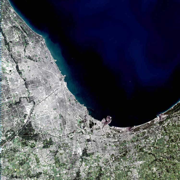
Despite being named after the Algonquian word for skunk, Chicago is one of America’s most thriving and spectacular cities. Spanning 22 miles along the southwest shore of Lake Michigan, the city itself holds nearly 2.9 million people and sits in the center of a metropolitan area containing more than 8 million.
Looking at the image, some of Chicago’s famous sites can be made out. The long black line coming into the center of the city from the southwest is the Chicago Sanitary and Ship Canal. In the center of the city, just right of where the canal banks north to become the Chicago River, sits a small pier on Lake Michigan, perpendicular to the city, known as Meigs Field. Just to the left of the pier is Soldier Field. Scanning north of Meigs Field, another pier juts out onto the lake. This is Navy Pier. Though it cannot be made out in the image, the Water Tower District and the John Hancock Building sit between Navy Pier and the Chicago River. South of this area is downtown Chicago and the Sears Tower.
This simulated-color scene was acquired by the Landsat 7 Enhanced Thematic Mapper plus (ETM+) on September 14, 2001.
Image courtesy Ron Beck, USGS Land Processes Data Center, Satellite Systems Branch
SOURCE: http://earthobservatory.nasa.gov/Newsroom/NewImages/images.php3?img_id=11277
”The purpose of NASA's Earth Observatory is to provide a freely-accessible publication on the Internet where the public can obtain new satellite imagery and scientific information about our home planet. The focus is on Earth's climate and environmental change. In particular, we hope our site is useful to public media and educators. Any and all materials published on the Earth Observatory are freely available for re-publication or re-use, except where copyright is indicated. We ask that NASA's Earth Observatory be given credit for its original materials.”
Picture prepared for Wikipedia by Adrian Pingstone in November 2003.
Uploaded to en: by en:User:Arpingstone on November 8, 2003
| Public domainPublic domainfalsefalse |
| De Datai is gmoafrai (public domain), wais vo da NASA erstöid worn is. In da NASA-Urheewerrechtsrichtlinie steet, dass as „NASA-Materiaal ned durch Urheewerrecht gschytzt is, wånns ned ånders ågeem is“. (NASA-Urheewerrechtsrichtlinie-Saiten oder JPL Image Use Policy). | ||
 |
Warnung:
|
en:Image:Chicago.landsat.750pix.jpg
Kurzbeschreibungen
In dieser Datei abgebildete Objekte
Motiv Deutsch
MIME-Typ Deutsch
image/jpeg
Prüfsumme Deutsch
f1bac6e65795ab411a93c283e95b290bbd2c1e80
Dateigröße Deutsch
113.894 Byte
750 Pixel
750 Pixel
Dateiversiona
Wensd auf an Zeitpunkt klickst, nacha konst a friaane Version lodn.
| Version vom | Vorschaubuidl | Dimensióna | Nutzer | Kommentar | |
|---|---|---|---|---|---|
| aktuell | 22:02, 17. Apr. 2005 | | 750 × 750 (111 KB) | Dubaduba~commonswiki | Category:Chicago from wikipedia |
Dateivawendung
Seitn wo de Datei nutzn:
Globale Dateinutzung
D'noochéfóiganden åndern Wikis vawénden dé Datei:
- Vawendung af af.wikipedia.org
- Vawendung af als.wikipedia.org
- Vawendung af ar.wikipedia.org
- Vawendung af br.wikipedia.org
- Vawendung af ceb.wikipedia.org
- Vawendung af cy.wikipedia.org
- Vawendung af en.wikipedia.org
- Chicago
- Gary, Indiana
- Zion, Illinois
- Will County, Illinois
- Kenosha County, Wisconsin
- Porter County, Indiana
- Newton County, Indiana
- LaPorte County, Indiana
- Lake County, Indiana
- Jasper County, Indiana
- McHenry County, Illinois
- Lake County, Illinois
- LaSalle County, Illinois
- Kendall County, Illinois
- Kankakee County, Illinois
- Kane County, Illinois
- Grundy County, Illinois
- DuPage County, Illinois
- DeKalb County, Illinois
- Cook County, Illinois
- Boone County, Illinois
- Evanston, Illinois
- Belvidere, Illinois
- Alsip, Illinois
- Arlington Heights, Illinois
- Barrington, Illinois
- Barrington Hills, Illinois
- Bartlett, Illinois
- Bedford Park, Illinois
- Bellwood, Illinois
- Bensenville, Illinois
- Berkeley, Illinois
- Berwyn, Illinois
- Blue Island, Illinois
- Bridgeview, Illinois
- Broadview, Illinois
- Brookfield, Illinois
- Buffalo Grove, Illinois
- Burbank, Illinois
- Burnham, Illinois
- Burr Ridge, Illinois
- Calumet City, Illinois
- Calumet Park, Illinois
- Chicago Heights, Illinois
Weitere globale Verwendungen dieser Datei anschauen.
Metadaten
De Datei enthoit weidane Informationa, wo in da Regl vo da Digitalkamara oda am gnutztn Scanna stamma. Duach a Beorbatung vo da Originaldatei kennan aa Details vaändat worn sei.
| Kameraausrichtung | Normal |
|---|---|
| Horizontale Auflösung | 100 dpi |
| Vertikale Auflösung | 100 dpi |
| Software | Adobe Photoshop 7.0 |
| Speicherzeitpunkt | 15:54, 14. Mer. 2003 |
| Farbraum | sRGB |