Файл:Rota_do_âmbar.jpg
From Wikipedia, the free encyclopedia
Rota_do_âmbar.jpg (411 × 599 кропак, аб’ём файла: 69 KB, тып MIME: image/jpeg)
Гэты файл з на Вікісховішчы і можа выкарыстоўвацца іншымі праектамі. Апісанне на яго старонцы ў Wikimedia Commons прыведзена ніжэй.

|
This map image could be re-created using vector graphics as an SVG file. This has several advantages; see Commons:Media for cleanup for more information. If an SVG form of this image is available, please upload it and afterwards replace this template with
{{vector version available|new image name}}.
It is recommended to name the SVG file “Rota do âmbar.svg”—then the template Vector version available (or Vva) does not need the new image name parameter. |
 | This map image was uploaded in the JPEG format even though it consists of non-photographic data. This information could be stored more efficiently or accurately in the PNG or SVG format. If possible, please upload a PNG or SVG version of this image without compression artifacts, derived from a non-JPEG source (or with existing artifacts removed). After doing so, please tag the JPEG version with {{Superseded|NewImage.ext}} and remove this tag. This tag should not be applied to photographs or scans. If this image is a diagram or other image suitable for vectorisation, please tag this image with {{Convert to SVG}} instead of {{BadJPEG}}. If not suitable for vectorisation, use {{Convert to PNG}}. For more information, see {{BadJPEG}}. |  |
Тлумачэнне
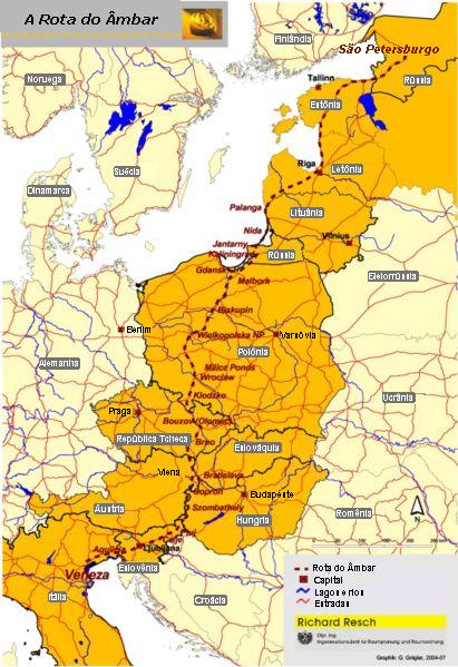
Amber Road on the map of Europe. Source: Map of the Amber Road in Portuguese. PD map taken from de:Bild:Bernsteinstrasse.jpg and modified by me. Uploaded by: User:Bonas
Ліцэнзіяванне
| Public domainPublic domainfalsefalse |
| Я, уладальнік аўтарскіх правоў на гэты твор, перадаю яго ў грамадскі набытак. Дазвол сапраўдны для ўсяго свету. У некаторых краінах гэта не можа быць юрыдычна магчыма; калі так, то: Я дазваляю кожнаму выкарыстоўваць гэтую працу ў любых мэтах, без аніякіх умоваў, калі толькі такія ўмовы не патрабуюцца паводле закону. |
Назвы
Элементы, адлюстраваныя на гэтым файле
адлюстроўвае
Гісторыя файла
Націснуць на даце з часам, каб паказаць файл, якім ён тады быў.
| Дата і час | Драбніца | Памеры | Удзельнік | Тлумачэнне | |
|---|---|---|---|---|---|
| актуальн. | 06:41, 27 жніўня 2006 | | 411 × 599 (69 KB) | Bonas | Amber Road on the map of Europe. Source: Map of the Amber Road in Portuguese. PD map taken from de:Bild:Bernsteinstrasse.jpg and modified by me. Uploaded by: User:Bonas Amber Road [[Category:O |
Выкарыстанне файла
Наступная 1 старонка выкарыстоўвае гэты файл:
Глабальнае выкарыстанне файла
Гэты файл выкарыстоўваецца ў наступных вікі:
- Выкарыстанне ў an.wikipedia.org
- Выкарыстанне ў da.wikipedia.org
- Выкарыстанне ў eo.wikipedia.org
- Выкарыстанне ў es.wikipedia.org
- Выкарыстанне ў et.wikipedia.org
- Выкарыстанне ў hr.wikipedia.org
- Выкарыстанне ў it.wikivoyage.org
- Выкарыстанне ў ko.wikipedia.org
- Выкарыстанне ў la.wikipedia.org
- Выкарыстанне ў mk.wikipedia.org
- Выкарыстанне ў pl.wikipedia.org
- Выкарыстанне ў pt.wikipedia.org
- Выкарыстанне ў sh.wikipedia.org
- Выкарыстанне ў sk.wikipedia.org
- Выкарыстанне ў sr.wikipedia.org
- Выкарыстанне ў sv.wikipedia.org
- Выкарыстанне ў th.wikipedia.org
- Выкарыстанне ў uk.wikipedia.org
- Соляний шлях (Україна)
- Шлях із варягів у греки
- Бурштин
- Ганза
- Великий шовковий шлях
- Манільські галеони
- Римські дороги
- Трикутникова торгівля
- Сибірський тракт
- Бурштиновий шлях
- Соляний шлях
- Шаблон:Історичні торговельні шляхи
- Via Maris
- Via Regia (Азія)
- Шлях пахощів
- Дорога спецій
- Великий колісний шлях
- Дороги інків
- Олов'яний шлях
- Волзький торговий шлях
- Індо-римська торгівля
- Царська дорога Персії
- Via Regia (Європа)
- Транссахарська торгівля
- Срібні каравани
Паказаць глабальнае выкарыстанне гэтага файла.
Метаданыя
У файле ёсць дадатковыя звесткі, магчыма, дададзеныя лічбавай фотакамерай ці сканерам, з якіх гэты файл паходзіць. Калі арыгінальны файл быў зменены, то частка гэтых звестак магла страціць актуальнасць у дачыненні да змененага файла.
| _error | 0 |
|---|