Restr:Czechoslovakia01.png
From Wikipedia, the free encyclopedia
Restr orin (1 100 × 468 piksel, ment ar restr : 63 Kio, seurt MIME : image/png)
![]()
| Tennet eo ar restr-mañ eus Wikimedia Commons ha gallout a ra bezañ implijet evit raktresoù all. Diskouezet eo deskrivadur he fajenn zeskrivañ amañ dindan. |
Diverradur
| DeskrivadurCzechoslovakia01.png |
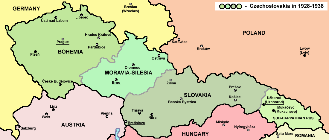
English: Map of Czechoslovakia in 1928-1938. Note: The provinces shown on the map were introduced by Act No. 125/1927 Zb. and became effective in 1928. Deutsch: Karte der Tschechoslowakei zwischen 1928 und 1938. |
|||
| Deiziad | ||||
| Mammenn |
Labour an-unan Main reference:
Secondary references with similar maps:
Secondary references about Geo-political situation - published sources:
Secondary reference about sizable cities: |
|||
| Aozer |
PANONIAN
|
|||
| Aotre (Adimplij ar restr-mañ) |
|
|||
| Stummoù all |
Derivative works of this file: |


|
This map image could be re-created using vector graphics as an SVG file. This has several advantages; see Commons:Media for cleanup for more information. If an SVG form of this image is available, please upload it and afterwards replace this template with
{{vector version available|new image name}}.
It is recommended to name the SVG file “Czechoslovakia01.svg”—then the template Vector version available (or Vva) does not need the new image name parameter. |
The production, editing or release of this file was supported by the Community-Budget of Wikimedia Deutschland. To see other files made with the support of Wikimedia Deutschland, please see the category Supported by Wikimedia Deutschland. العربية ∙ বাংলা ∙ Deutsch ∙ English ∙ Esperanto ∙ français ∙ magyar ∙ Bahasa Indonesia ∙ italiano ∙ 日本語 ∙ македонски ∙ മലയാളം ∙ Bahasa Melayu ∙ Nederlands ∙ português ∙ русский ∙ slovenščina ∙ svenska ∙ українська ∙ தமிழ் ∙ +/−
|
Captions
Items portrayed in this file
diskouez a ra
some value
2006
source of file saozneg
original creation by uploader saozneg
image/png
checksum saozneg
bd003d1960e9404724758c8fa7f85ee852d01738
64 020 byte
468 pixel
1 100 pixel
Istor ar restr
Klikañ war un deiziad/eur da welet ar restr evel ma oa da neuze.
| Deiziad/Eur | Munud | Mentoù | Implijer | Notenn | |
|---|---|---|---|---|---|
| red | 12 Gou 2022 da 14:48 | | 1 100 × 468 (63 Kio) | Sebastian Wallroth | cropped |
| 19 Mae 2011 da 10:54 |  | 1 128 × 513 (63 Kio) | PANONIAN | minor change, marked provincial capitals | |
| 17 Mae 2011 da 09:53 |  | 1 128 × 513 (62 Kio) | PANONIAN | Reverted to version as of 10:38, 24 April 2011 - because this is map of Czechoslovakia and it was capital of Czechoslovakia | |
| 17 Mae 2011 da 05:07 |  | 1 128 × 513 (55 Kio) | Millenium187 | Why was Prague underlined and Vienna, Brno, Bratislava and other capital cities were not? -- corrected | |
| 24 Ebr 2011 da 10:38 |  | 1 128 × 513 (62 Kio) | PANONIAN | few corrections | |
| 23 Ebr 2011 da 11:31 |  | 1 128 × 509 (61 Kio) | PANONIAN | improved version | |
| 20 Kzu 2008 da 20:58 |  | 1 100 × 497 (78 Kio) | Kirk979 | {{Information |Description= |Source= |Date= |Author= |Permission= |other_versions= }} | |
| 28 Kzu 2006 da 16:11 |  | 1 100 × 497 (90 Kio) | Electionworld | {{ew|en|PANONIAN}} Map of {{link|Czechoslovakia}} (self made) Note: The provinces shown on the map were introduced by Act No. 125/1927 Zb. and became effective in 1928. {{PD-self}} Category:Maps of Czechoslovakia Category:Maps of Czech history |
Implij ar restr
Implijout a ra ar bajenn da heul ar restr-mañ :
Implij hollek ar restr
Ober a ra ar wikioù da-heul gant ar restr-mañ :
- Implij war af.wikipedia.org
- Implij war als.wikipedia.org
- Implij war ang.wikipedia.org
- Implij war an.wikipedia.org
- Implij war ar.wikipedia.org
- Implij war arz.wikipedia.org
- Implij war azb.wikipedia.org
- Implij war az.wikipedia.org
- Implij war bar.wikipedia.org
- Implij war ba.wikipedia.org
- Implij war bcl.wikipedia.org
- Implij war be-tarask.wikipedia.org
- Implij war be.wikipedia.org
- Implij war bg.wikipedia.org
- Implij war bn.wikipedia.org
- Implij war ca.wikipedia.org
- Implij war cs.wikipedia.org
- Implij war cv.wikipedia.org
- Implij war cy.wikipedia.org
- Implij war de.wikipedia.org
- Implij war diq.wikipedia.org
- Implij war dsb.wikipedia.org
- Implij war el.wikipedia.org
- Implij war en.wikipedia.org
Gwelet muioc'h eus implij hollek ar restr-mañ.
Metaroadennoù
Titouroù ouzhpenn zo er restr-mañ; bet lakaet moarvat gant ar c'hamera niverel pe ar skanner implijet evit he niverelaat. Mard eo bet cheñchet ar skeudenn e-keñver he stad orin marteze ne vo ket kenkoulz munudoù zo e-keñver ar skeudenn kemmet.
| Pizhder led ar skeudenn | 28,35 dpc |
|---|---|
| Pizhder hed ar skeudenn | 28,35 dpc |