Restr:Korean_war_1950-1953.gif
From Wikipedia, the free encyclopedia
Ment ar rakweled-mañ : 387 × 600 piksel. pizhderioù all : 155 × 240 piksel | 562 × 871 piksel.
Restr orin (562 × 871 piksel, ment ar restr : 1,32 Mio, seurt MIME : image/gif, e kelc'h, 20 skeudenn, 30 s)
![]()
| Tennet eo ar restr-mañ eus Wikimedia Commons ha gallout a ra bezañ implijet evit raktresoù all. Diskouezet eo deskrivadur he fajenn zeskrivañ amañ dindan. |
| The image contains one or several undisputed inaccuracies.
It should not be used to illustrate or provide information about the subject, but may be kept in order to provide the basis for a corrected image. If you disagree that it may be useful for this purpose feel free to request deletion. Reason:
Issue A: 07.1953 map (end of the gif) is definitely inaccurate because: (1) the July 1953 armistice includes the following statement: "all the islands lying to the north and west of the provincial boundary line between HWANGHAE-DO and KYONGGI-DO shall be under the military control of the Supreme Commander of the Korean People's Army and the Commander of the Chinese People's volunteers, except the island groups of PAENGYONG-DO (37 58' N, 124 40' E), TAECHONG-DO (37 50' N, 124 42' E), SOCHONG-DO (37 46' N, 124 46' E), YONPYONG-DO (37 38' N, 125 40' E), and U-DO (37 36'N, 125 58' E), which shall remain under the military control of the Commander-in-Chief, United Nations Command." and (2) the island Baengnyeongdo (PAENGYONG-DO) is colored pink on the 07.1953 map. We see in the statement above that the island shall remain under UN military control (July 1953) and hence should likely be colored green in the 07.1953 map and possibly other maps. If the lack of precision which causes this error on the 07.1953 map is true of the whole series of maps, then this gif really needs reviewing. Issue B: Ulleungdo, which is larger in land area than the above-mentioned Baengnyeongdo and is part of Korea, should be part of this map, and not including it is an error. Why ignore a part of Korean territory? |
Diverradur
| DeskrivadurKorean war 1950-1953.gif |
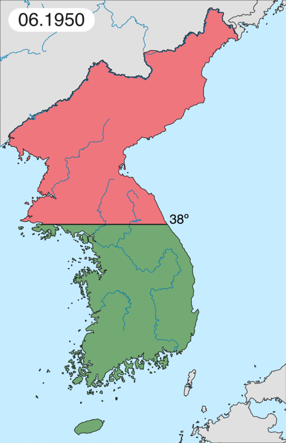
English: Map of Korean war from May 1950 to July 1951, showing:
Français : Carte de la guerre de Corée de mai 1950 à juillet 1951, montrant:
Deutsch: Karte des Koreakriegs von Mai 1950 bis Juli 1951, abgebildet:
Italiano: Mappa della guerra di Corea dal maggio 1950 al luglio 1951, rappresentante:
|
| Deiziad | |
| Mammenn | Labour an-unan |
| Aozer | Leomonaci98 |
Aotre-implijout
Evel perc'henn eus ar gwirioù oberour, e embannan an oberenn-mañ dindan an aotreoù-implijout da-heul :

|
Aotre zo da eilañ, skignañ ha kemmañ an teul-mañ dindan termennoù ar GNU Free Documentation License, stumm 1.2 pe stummoù nevesoc'h embannet gant ar Free Software Foundation; hep rannoù digemm, na testenn pajenn golo 1 pe golo 4 ebet. Kavet e vo un eilskrid eus an aotre-implijout er rannbennad anvet GNU Free Documentation License.http://www.gnu.org/copyleft/fdl.htmlGFDLGNU Free Documentation Licensetruetrue |
| Emañ ar restr-mañ dindan an aotre-implijout Creative Commons Deroadenn-Kenrannañ 3.0 Unported | ||
| ||
| Ouzhpennet eo bet an dikedenn aotre-implijout-mañ d'ar restr-mañ evel darn eus hizivadur aotreoù-implijout ar GFDL.http://creativecommons.org/licenses/by-sa/3.0/CC BY-SA 3.0Creative Commons Attribution-Share Alike 3.0truetrue |
Gallout a rit diuzañ an aotre-implijout a fell deoc'h.
Captions
Add a one-line explanation of what this file represents
It represents the land Korea gained
Kore'nin kazandığı toprakları teslim ediyor
Items portrayed in this file
diskouez a ra
source of file saozneg
original creation by uploader saozneg
5 Mez 2006
image/gif
Istor ar restr
Klikañ war un deiziad/eur da welet ar restr evel ma oa da neuze.
| Deiziad/Eur | Munud | Mentoù | Implijer | Notenn | |
|---|---|---|---|---|---|
| red | 16 C'hwe 2020 da 20:20 | | 562 × 871 (1,32 Mio) | Leomonaci98 | Graphic update |
| 1 Mae 2013 da 01:02 |  | 227 × 400 (85 Kio) | Spesh531 | update for every month | |
| 9 Mez 2006 da 08:47 |  | 227 × 400 (37 Kio) | Roke~commonswiki | rm white | |
| 8 Mez 2006 da 06:25 |  | 227 × 400 (37 Kio) | Roke~commonswiki | add OngJin peninsula after comment, also blank frame at end | |
| 5 Mez 2006 da 15:14 |  | 227 × 400 (37 Kio) | Roke~commonswiki | Korean war, showing North Korean, Chinese and communist forces (red); South Korean, US and United Nations forces (green). Category: Korean War Category: Animated maps |
Implij ar restr
Implijout a ra ar bajenn da heul ar restr-mañ :
Implij hollek ar restr
Ober a ra ar wikioù da-heul gant ar restr-mañ :
- Implij war af.wikipedia.org
- Implij war az.wikipedia.org
- Implij war bat-smg.wikipedia.org
- Implij war bg.wikipedia.org
- Implij war bs.wikipedia.org
- Implij war ca.wikipedia.org
- Corea del Nord
- Corea del Sud
- Ióssif Stalin
- Mao Zedong
- Winston Churchill
- Harry Truman
- Guerra de Corea
- Kim Il-sung
- Viatxeslav Mólotov
- Gueorgui Malenkov
- Douglas MacArthur
- Lavrenti Béria
- M*A*S*H (pel·lícula)
- Clement Attlee
- Mark Wayne Clark
- Zona desmilitaritzada de Corea
- República Popular d'Hongria
- Syngman Rhee
- Peng Dehuai
- Força Aèria de l'Exèrcit Popular de Corea
- Forces Armades de Corea del Nord
- Forces Armades de la República de Corea
- 65è Regiment d'Infanteria (Estats Units)
- Frontera entre Corea del Nord i Corea del Sud
- Kim Chaek
- Batalla d'Inchon
- Plantilla:Guerra de Corea
- Pak Hon-yong
- Implij war ckb.wikipedia.org
- Implij war cs.wikipedia.org
- Implij war cy.wikipedia.org
- Implij war da.wikipedia.org
- Implij war de.wikipedia.org
- Implij war el.wikipedia.org
- Implij war en.wikipedia.org
Gwelet muioc'h eus implij hollek ar restr-mañ.
Adtapet diwar « https://br.wikipedia.org/wiki/Restr:Korean_war_1950-1953.gif »