File:FuehrerBunkerBerlinLocation.jpg
From Wikipedia, the free encyclopedia
Fitxer original (700 × 830 píxels, mida del fitxer: 532 Ko, tipus MIME: image/jpeg)
| Aquest fitxer i la informació mostrada a continuació provenen del dipòsit multimèdia lliure Wikimedia Commons. |
| DescripcióFuehrerBunkerBerlinLocation.jpg |
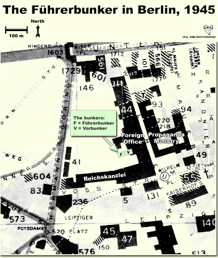
Map showing the locations of the Fuehrerbunker and Vorbunker in Berlin, 1945. |
| Data | |
| Font | Treball propi |
| Autor | User:Dna-Dennis |
| Permís (Com reutilitzar aquest fitxer) |
CC, see below. The map is completely unrestricted for any Wikipedia/Wikimedia project. |
Contingut
Llicència
- Sou lliure de:
- compartir – copiar, distribuir i comunicar públicament l'obra
- adaptar – fer-ne obres derivades
- Amb les condicions següents:
- reconeixement – Heu de donar la informació adequada sobre l'autor, proporcionar un enllaç a la llicència i indicar si s'han realitzat canvis. Podeu fer-ho amb qualsevol mitjà raonable, però de cap manera no suggereixi que l'autor us dóna suport o aprova l'ús que en feu.
Resum
This is a map showing the locations of the Fuehrerbunker and Vorbunker in Berlin, 1945. These locations are not necessarily perfectly exact, but they are very probable. There were two bunkers which were connected - the Fuehrerbunker and the Vorbunker, and here are the links to my maps of these bunkers:
Information about the details of the bunkers is rather scarce, which is not strange, since the bunkers were secret. This map is based on the excellent research of Tom Posch (see below), who visited and photographed the remains from inside in 1988. He concluded that the map of the bunker in Cornelius Ryan's The Last Battle was incorrect, and a new, hand-drawn map of the Vorbunker was produced by Tom Posch.
Notes on the location of the bunkers
The Fuehrerbunker, built in 1943/44, was located 8-17 meters beneath the Reichskanzlei garden, approx. 120 meters north of the new Reichskanzlei building, which had the address Vossstrasse 6. The Führerbunker was located somewhat lower than the Vorbunker and west (or rather west-west-south) of it. The two bunkers were connected via sets of stairs set at right angles (not spiral).
Construction data (approximates)
- Material: Concrete
- Protective Wall Width: 220 cm
- Protective Roof Height: 280 cm
- Wall Width (interior): 15-20 cm
- Door Heights: 180-200 cm
- Door Widths: 120 cm
- Room Heights: 2-3 m
- Room Sizes: Varying; 3-5 m
References
The map is based on the following sources:
- Ramsey, Winston G. (editor) & Posch, Tom (researcher), The Berlin Führerbunker: The Thirteenth Hole, After the Battle archive copy at the Wayback Machine, No.61, Special Edition, Battle of Britain International Ltd, 1988, London
- Allied Intelligence Map of Key Buildings in Berlin (3rd edition, 1945)
- Ryan, Cornelius, The Last Battle (1966)
Regards,
Dennis Nilsson, Sweden.
If you wish to contact me, please leave a message on my talk page.
Llegendes
Elements representats en aquest fitxer
representa l'entitat
12 oct 2007
Historial del fitxer
Cliqueu una data/hora per veure el fitxer tal com era aleshores.
| Data/hora | Miniatura | Dimensions | Usuari/a | Comentari | |
|---|---|---|---|---|---|
| actual | 04:37, 12 oct 2007 | | 700 × 830 (532 Ko) | Dna-webmaster~commonswiki | minor fix |
| 04:06, 12 oct 2007 |  | 700 × 830 (530 Ko) | Dna-webmaster~commonswiki | Uploaded new version | |
| 02:19, 14 des 2005 |  | 720 × 946 (442 Ko) | Dna-webmaster~commonswiki | ||
| 10:30, 14 nov 2005 |  | 720 × 946 (453 Ko) | Dna-webmaster~commonswiki |
Ús del fitxer
No hi ha pàgines que utilitzin aquest fitxer.
Ús global del fitxer
Utilització d'aquest fitxer en altres wikis:
- Utilització a ar.wikipedia.org
- Utilització a ast.wikipedia.org
- Utilització a br.wikipedia.org
- Utilització a el.wikipedia.org
- Utilització a en.wikipedia.org
- Utilització a es.wikipedia.org
- Utilització a fi.wikipedia.org
- Utilització a fr.wikipedia.org
- Utilització a hu.wikipedia.org
- Utilització a ja.wikipedia.org
- Utilització a ru.wikipedia.org
Metadades
Aquest fitxer conté informació addicional, probablement afegida per la càmera digital o l'escàner utilitzat per a crear-lo o digitalitzar-lo. Si s'ha modificat posteriorment, alguns detalls poden no reflectir les dades reals del fitxer modificat.
| Orientació | Normal |
|---|---|
| Resolució horitzontal | 200 ppp |
| Resolució vertical | 200 ppp |
| Programari utilitzat | Adobe Photoshop 7.0 |
| Data i hora de modificació del fitxer | 04:45, 12 oct 2007 |
| Espai de color | Sense calibrar |