Fitxer:Czechoslovakia01.png
From Wikipedia, the free encyclopedia
Fitxer original (1.100 × 468 píxels, mida del fitxer: 63 Ko, tipus MIME: image/png)
| Aquest fitxer i la informació mostrada a continuació provenen del dipòsit multimèdia lliure Wikimedia Commons. |
Resum
| DescripcióCzechoslovakia01.png |
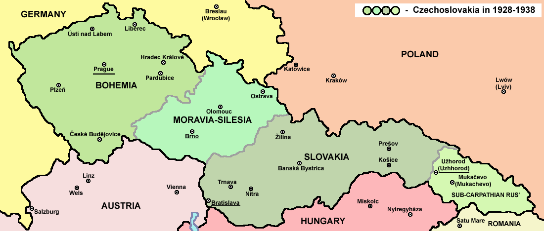
English: Map of Czechoslovakia in 1928-1938. Note: The provinces shown on the map were introduced by Act No. 125/1927 Zb. and became effective in 1928. Deutsch: Karte der Tschechoslowakei zwischen 1928 und 1938. |
|||
| Data | ||||
| Font |
Treball propi Main reference:
Secondary references with similar maps:
Secondary references about Geo-political situation - published sources:
Secondary reference about sizable cities: |
|||
| Autor |
PANONIAN
|
|||
| Permís (Com reutilitzar aquest fitxer) |
|
|||
| Altres versions |
Derivative works of this file: |


|
Aquesta imatge (de tipus mapa) s'hauria de tornar a crear utilitzant gràfics vectorials com ara un fitxer SVG. Això té diversos avantatges; en trobareu més informació a Commons:Media for cleanup. Si ja disposeu d'una versió d'aquesta imatge en format SVG, us preguem que la pengeu; després, reemplaceu aquesta plantilla amb la plantilla {{Vector version available|nom nou de la imatge.svg}} en aquesta imatge.
|
The production, editing or release of this file was supported by the Community-Budget of Wikimedia Deutschland. To see other files made with the support of Wikimedia Deutschland, please see the category Supported by Wikimedia Deutschland. العربية ∙ বাংলা ∙ Deutsch ∙ English ∙ Esperanto ∙ français ∙ magyar ∙ Bahasa Indonesia ∙ italiano ∙ 日本語 ∙ македонски ∙ മലയാളം ∙ Bahasa Melayu ∙ Nederlands ∙ português ∙ русский ∙ slovenščina ∙ svenska ∙ українська ∙ +/−
|
Llegendes
Elements representats en aquest fitxer
representa l'entitat
Algun valor sense element de Wikidata
image/png
bd003d1960e9404724758c8fa7f85ee852d01738
64.020 byte
468 píxel
1.100 píxel
Historial del fitxer
Cliqueu una data/hora per veure el fitxer tal com era aleshores.
| Data/hora | Miniatura | Dimensions | Usuari/a | Comentari | |
|---|---|---|---|---|---|
| actual | 16:48, 12 jul 2022 | | 1.100 × 468 (63 Ko) | Sebastian Wallroth | cropped |
| 12:54, 19 maig 2011 |  | 1.128 × 513 (63 Ko) | PANONIAN | minor change, marked provincial capitals | |
| 11:53, 17 maig 2011 |  | 1.128 × 513 (62 Ko) | PANONIAN | Reverted to version as of 10:38, 24 April 2011 - because this is map of Czechoslovakia and it was capital of Czechoslovakia | |
| 07:07, 17 maig 2011 |  | 1.128 × 513 (55 Ko) | Millenium187 | Why was Prague underlined and Vienna, Brno, Bratislava and other capital cities were not? -- corrected | |
| 12:38, 24 abr 2011 |  | 1.128 × 513 (62 Ko) | PANONIAN | few corrections | |
| 13:31, 23 abr 2011 |  | 1.128 × 509 (61 Ko) | PANONIAN | improved version | |
| 22:58, 20 des 2008 |  | 1.100 × 497 (78 Ko) | Kirk979 | {{Information |Description= |Source= |Date= |Author= |Permission= |other_versions= }} | |
| 18:11, 28 des 2006 |  | 1.100 × 497 (90 Ko) | Electionworld | {{ew|en|PANONIAN}} Map of {{link|Czechoslovakia}} (self made) Note: The provinces shown on the map were introduced by Act No. 125/1927 Zb. and became effective in 1928. {{PD-self}} Category:Maps of Czechoslovakia Category:Maps of Czech history |
Ús del fitxer
Les 5 pàgines següents utilitzen aquest fitxer:
Ús global del fitxer
Utilització d'aquest fitxer en altres wikis:
- Utilització a af.wikipedia.org
- Utilització a als.wikipedia.org
- Utilització a ang.wikipedia.org
- Utilització a an.wikipedia.org
- Utilització a ar.wikipedia.org
- Utilització a arz.wikipedia.org
- Utilització a azb.wikipedia.org
- Utilització a az.wikipedia.org
- Utilització a bar.wikipedia.org
- Utilització a ba.wikipedia.org
- Utilització a bcl.wikipedia.org
- Utilització a be-tarask.wikipedia.org
- Utilització a be.wikipedia.org
- Utilització a bg.wikipedia.org
- Utilització a bn.wikipedia.org
- Utilització a br.wikipedia.org
- Utilització a cs.wikipedia.org
- Utilització a cv.wikipedia.org
- Utilització a cy.wikipedia.org
- Utilització a de.wikipedia.org
- Utilització a diq.wikipedia.org
- Utilització a dsb.wikipedia.org
- Utilització a el.wikipedia.org
- Utilització a en.wikipedia.org
Vegeu més usos globals d'aquest fitxer.
Metadades
Aquest fitxer conté informació addicional, probablement afegida per la càmera digital o l'escàner utilitzat per a crear-lo o digitalitzar-lo. Si s'ha modificat posteriorment, alguns detalls poden no reflectir les dades reals del fitxer modificat.
| Resolució horitzontal | 28,35 ppc |
|---|---|
| Resolució vertical | 28,35 ppc |