Fitxer:United_States_1789-03-1789-08.png
From Wikipedia, the free encyclopedia
Mida d'aquesta previsualització: 800 × 542 píxels. Altres resolucions: 320 × 217 píxels | 640 × 433 píxels | 1.000 × 677 píxels.
Fitxer original (1.000 × 677 píxels, mida del fitxer: 97 Ko, tipus MIME: image/png)
| Aquest fitxer i la informació mostrada a continuació provenen del dipòsit multimèdia lliure Wikimedia Commons. |
- Legend
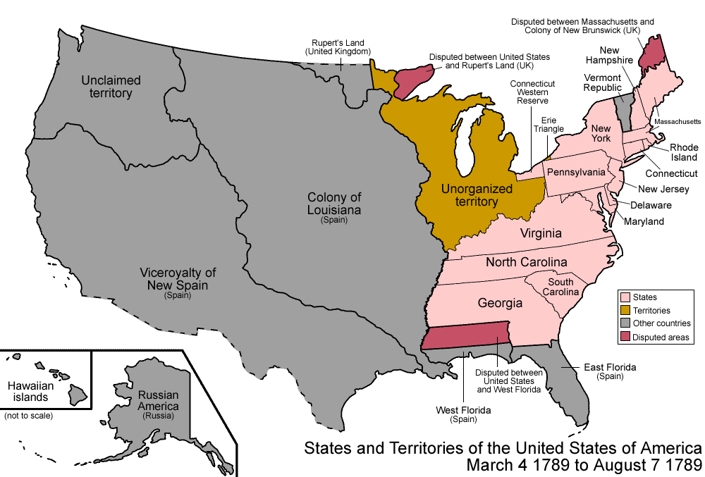
| DescripcióUnited States 1789-03-1789-08.png | Map of the states and territories of the United States as it was from March 1789 to August 1789. On March 4 1789, the United States Constitution was enacted, though not all of the states had joined the union by then; to simplify this map, they are shown anyway. On August 7 1789, the Territory North West of the Ohio River (Northwest Territory) was organized. |
| Font | Treball propi |
| Autor | Made by User:Golbez. |
| Permís (Com reutilitzar aquest fitxer) |
Own work, attribution required (Multi-license with GFDL and Creative Commons CC-BY 2.5) |
| Altres versions |
Derivative works of this file: |

|
Aquesta imatge (de tipus historical map) s'hauria de tornar a crear utilitzant gràfics vectorials com ara un fitxer SVG. Això té diversos avantatges; en trobareu més informació a Commons:Media for cleanup. Si ja disposeu d'una versió d'aquesta imatge en format SVG, us preguem que la pengeu; després, reemplaceu aquesta plantilla amb la plantilla {{Vector version available|nom nou de la imatge.svg}} en aquesta imatge.
|
Jo, el titular dels drets d'autor d'aquest treball, el public sota les següents llicències:

|
S'autoritza la còpia, la distribució i la modificació d'aquest document sota els termes de la llicència de documentació lliure GNU versió 1.2 o qualsevol altra versió posterior que publiqui la Free Software Foundation; sense seccions invariants, ni textos de portada, ni textos de contraportada. S'inclou una còpia d'aquesta llicència en la secció titulada GNU Free Documentation License.http://www.gnu.org/copyleft/fdl.htmlGFDLGNU Free Documentation Licensetruetrue |
| Aquest fitxer està subjecte a la llicència de Creative Commons Reconeixement i Compartir Igual 3.0 No adaptada. | ||
| ||
| Aquest avís de llicència s'ha afegit a aquest fitxer d'acord amb l'actualització de la llicència GFDL.http://creativecommons.org/licenses/by-sa/3.0/CC BY-SA 3.0Creative Commons Attribution-Share Alike 3.0truetrue |
Aquest fitxer està disponible sota la llicència Creative Commons Reconeixement 2.5 Genèrica.
- Sou lliure de:
- compartir – copiar, distribuir i comunicar públicament l'obra
- adaptar – fer-ne obres derivades
- Amb les condicions següents:
- reconeixement – Heu de donar la informació adequada sobre l'autor, proporcionar un enllaç a la llicència i indicar si s'han realitzat canvis. Podeu fer-ho amb qualsevol mitjà raonable, però de cap manera no suggereixi que l'autor us dóna suport o aprova l'ús que en feu.
Podeu seleccionar la llicència que vulgueu.
| Territorial evolution maps of the United States |
| v · d (template shows date of beginning of change yyyy-mm-dd) |
| 1789-03, 1789-08, 1790-04, 1790-05, 1791-03, 1791-09, 1792-03, 1792-06, 1795, 1796, 1798, 1800-07-04, 1800-07, 1802, 1803-03, 1803-04, 1804-03, 1804-10, 1805-01, 1805-07, 1809, 1810-04, 1810-10, 1812-04, 1812-05, 1812-06, 1816, 1817-03, 1817-12, 1818-10, 1818-12, 1819-03, 1819-12, 1820, 1821-07, 1821, 1822, 1824, 1828, 1834, 1836-03, 1836-06, 1836-07, 1837-01, 1837-03, 1838, 1842, 1845-03, 1845-12, 1846-06, 1846-12, 1848-02, 1848-05, 1848-08, 1849, 1850, 1853-03, 1853-12, 1854, 1858, 1859, 1860, 1861-01, 1861-02-04, 1861-02-28, 1861-03, 1861-08, 1862, 1863-02, 1863-03, 1863-06, 1864-05, 1864-10, 1865, 1866, 1867-01, 1867-03, 1867-10, 1868, 1876, 1884, 1889-11-02, 1889-11-08, 1889-11-11, 1890-05, 1890-07-03, 1890-07-10, 1896-01, 1896-05, 1898, 1907, 1912-01, 1912-02, 1912-08, 1959-01, 1959-08 |
Llegendes
Afegeix una explicació d'una línia del que representa aquest fitxer
Elements representats en aquest fitxer
representa l'entitat
Historial del fitxer
Cliqueu una data/hora per veure el fitxer tal com era aleshores.
| Data/hora | Miniatura | Dimensions | Usuari/a | Comentari | |
|---|---|---|---|---|---|
| actual | 12:58, 14 ago 2007 | | 1.000 × 677 (97 Ko) | Golbez |
Ús del fitxer
La pàgina següent utilitza aquest fitxer:
Ús global del fitxer
Utilització d'aquest fitxer en altres wikis:
- Utilització a ar.wikipedia.org
- Utilització a de.wikipedia.org
- Utilització a en.wikipedia.org
- American frontier
- History of the United States (1789–1815)
- History of North Dakota
- Federalist No. 3
- User:Buaidh/Territorial evolution of Colorado
- American pioneer
- User:Phuntsok Tsepel
- List of territorial claims and designations in Colorado
- Territorial evolution of New Mexico
- Outline of Wyoming territorial evolution
- Territorial evolution of Montana
- Territorial evolution of Idaho
- Outline of Washington territorial evolution
- Outline of Oregon territorial evolution
- Territorial evolution of Utah
- Territorial evolution of Arizona
- Territorial evolution of Nevada
- Territorial evolution of California
- Outline of North Dakota territorial evolution
- Territorial evolution of South Dakota
- User:Lodzdeena/ABŞ tarixi (1789–1849)
- User:Lodzdeena/test
- Utilització a es.wikipedia.org
- Utilització a et.wikipedia.org
- Utilització a fa.wikipedia.org
- Utilització a fr.wikipedia.org
- Utilització a hu.wikipedia.org
- Utilització a id.wikipedia.org
- Utilització a ja.wikipedia.org
- Utilització a lt.wikipedia.org
- Utilització a nl.wikipedia.org
- Utilització a no.wikipedia.org
- Utilització a pt.wikipedia.org
- Utilització a ro.wikipedia.org
- Utilització a ru.wikipedia.org
- Utilització a sv.wikipedia.org
- Utilització a uk.wikipedia.org
- Utilització a vi.wikipedia.org
- Utilització a zh.wikipedia.org
Vegeu més usos globals d'aquest fitxer.