Payl:Bickington_Village_Church_-_geograph.org.uk_-_13082.jpg
From Wikipedia, the free encyclopedia
Walay mas taas nga resolusyon.
Bickington_Village_Church_-_geograph.org.uk_-_13082.jpg (630 × 448 pixels, size sa payl: 74 KB, MIME type: image/jpeg)
Kining maong payl gikan sa Wikimedia Commons ug mahimong gigamit sa ubang proyekto. Ang deskripsyon niini didto gipakita sa ubos.
Mubong sugid:
| DeskripsyonBickington Village Church - geograph.org.uk - 13082.jpg |
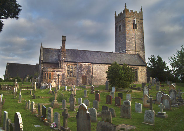
English: Bickington Village Church. This image shows the cramped graveyard and rear side of the St Mary the Virgin church. It has no permanent vicar and is attached to the main parish church in the nearby town of Ashburton. |
| Petsa | |
| Gigikanan | From geograph.org.uk |
| Tagsulat | Mike Crowe |
| Attribution (required by the license) InfoField | Mike Crowe / Bickington Village Church / |
InfoField | Mike Crowe / Bickington Village Church |
| Object location | 50° 32′ 29″ N, 3° 41′ 46″ W | View this and other nearby images on: OpenStreetMap |
|---|
Pagtugot

|
This image was taken from the Geograph project collection. See this photograph's page on the Geograph website for the photographer's contact details. The copyright on this image is owned by Mike Crowe and is licensed for reuse under the Creative Commons Attribution-ShareAlike 2.0 license.
|
This file is licensed under the Creative Commons Attribution-Share Alike 2.0 Generic license.
Attribution: Mike Crowe
- Libre ka:
- sa pagsabwag – sa pagkopya, pag-apod-apod ug pagsabwag sa hinimo
- sa pag-remix – sa pag-adap sa binuhat
- Ubos sa mosunod nga mga kondisyon:
- atribusyon – Kinahanglan nimo nga hatagan ang angay nga kredito, maghatag usa ka link sa lisensya, ug ipakita kung adunay mga pagbag-o. Mahimo nimo kini buhaton sa bisan unsang makatarunganon nga paagi, apan dili sa bisan unsang paagi nga nagsugyot nga gi-endorso ka sa licensor o ang imong paggamit.
- share parehas – Kung imong gi-remix, gibag-o, o gibase sa materyal, kinahanglan nimo nga iapod-apod ang imong mga kontribusyon sa ilawom sa parehas o katugma nga lisensya sama sa orihinal.
Captions
Add a one-line explanation of what this file represents
creator English
some value
copyright status English
copyrighted English
source of file English
file available on the internet English
27 Mayo 2005
location of creation English
coordinates of depicted place English
50°32'28.7"N, 3°41'45.6"W
media type English
image/jpeg
checksum English
1e2a1a16faf2dcc1d457741a8eb05b541df23964
data size English
76,266 byte
height English
448 pixel
width English
630 pixel
Kaagi sa payl
I-klik ang petsa/oras aron makit-an ang hulagway sa payl niadtong panahona.
| Petsa/Takna | Thumbnail | Mga dimensyon | Tiggamit | Komento | |
|---|---|---|---|---|---|
| kasamtangan | 18:35, 20 Marso 2010 | | 630 × 448 (74 KB) | Cropbot | upload cropped version, operated by User:Finavon. Summary: border cropped |
| 01:32, 30 Enero 2010 |  | 640 × 459 (96 KB) | GeographBot | == {{int:filedesc}} == {{Information |description={{en|1=Bickington Village Church. This image shows the cramped graveyard and rear side of the St Mary the Virgin church. It has no permanent vicar and is attached to the main parish church in the nearby to |
Mga paggamit sa payl
Ang mosunod nga mga panid misumpay niining payl:
Global nga paggamit sa payl
Kining ubang wiki naggamit ning maong payl:
- Paggamit sa arz.wikipedia.org
- Paggamit sa cy.wikipedia.org
- Paggamit sa en.wikipedia.org
- Paggamit sa fr.wikipedia.org
- Paggamit sa lld.wikipedia.org
- Paggamit sa nl.wikipedia.org
- Paggamit sa pl.wikipedia.org
- Paggamit sa www.wikidata.org
Metadata
Ang kining payl adunay dugang nga impormasyon, mahimong nadugang gikan sa digital camera o scanner nga gigamit sa paghimo o pag-digitize niini.
Kon ang payl namodipikar gikan sa orihinal nga estado, ang ubang detalye mamahimong dili moreplek sa namodipikar nga payl.
| _error | 0 |
|---|