Soubor:Italy_1494_AD.png
From Wikipedia, the free encyclopedia

Velikost tohoto náhledu: 419 × 600 pixelů. Jiná rozlišení: 168 × 240 pixelů | 335 × 480 pixelů | 536 × 768 pixelů | 1 261 × 1 805 pixelů.
Původní soubor (1 261 × 1 805 pixelů, velikost souboru: 144 KB, MIME typ: image/png)
| Tento soubor pochází z Wikimedia Commons. Níže jsou zobrazeny informace, které obsahuje jeho tamější stránka s popisem souboru. |
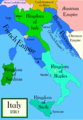
The factual accuracy of this map or the file name is disputed.
Reason: Do not use this map until SVG is corrected and PNG updated, as it is mostly based on the Shepherd's map which shows innacurate history of Venetian Republic on Eastern Adriatic, specifically of Dalmatia. It is showing seriouly erroneous and misleading Venetian control over whole region of modern Dalmatia - which became in full extent only in the late 17th and 18th century. It was never the case in the 15th and 16th century, as then most part of Dalmatian hinterland was under Hungarian-Croatian Kingdom and then Ottoman Empire. Venetian Dalmatia at the time included only the very coastal part of Dalmatia with very near hinterland of the Dalmatian city-states, the majority of the hinterland was not Venetian at all. The borders of the Ottoman conquest are also significantly erroneous for the time period as in the map look like modern borders of Bosnia and Herzegovina which became the case only many centuries later.
The map omits a lot of Venice, both islands such as Crete, and coastal areas such as Kotor. |  |

|
K tomuto obrázku existuje vektorová verze (v SVG). Pokud je lepší, používejte raději tu.
File:Italy 1494 AD.png → File:Italy 1494 AD-it.svg
Podrobnější informace o vektorové grafice najdete na stránce Commons:Transition to SVG. Také si můžete přečíst informace o podpoře formátu SVG v MediaWiki.
|
 |
Popis
Political map of Italy in early 1494, before the invasion of Italy by Charles VIII of France, created by MapMaster.
Part of a series of maps on the history of Italy:
-
 1000 AD
 -
 1084 AD
 -
 1796 AD
 -
 1810 AD


Versions
[editovat]
PNG:
-
 arabština
 -
 angličtina
 -
 řečtina


SVG:
-
 francouzština
 -
 italština
 -
 maďarština


References
- Bjorklund, Oddvar; Holmboe, Haakon; Rohr, Anders (1970) Historical Atlas of the World, Barnes & Noble, NY, SBN: 389-00253-4.
- Matthew, Donald, (1983), Atlas of Medieval Europe, Checkmark Books, New York.
- Online maps, including this 1882 map from Shepherd (the University of Texas)
- this one from A B Longman, textbook publisher.
Licence
Já, držitel autorských práv k tomuto dílu, ho tímto zveřejňuji za podmínek následujících licencí:

|
Tento dokument smí být kopírován, šířen nebo upravován podle podmínek Svobodné licence GNU pro dokumenty verze 1.2 nebo libovolné vyšší verze publikované nadací Free Software Foundation. Dokument nemá neměnné části ani texty na předním či zadním přebalu. Kopie textu licence je k dispozici v oddíle nazvaném GNU Free Documentation License.http://www.gnu.org/copyleft/fdl.htmlGFDLGNU Free Documentation Licensetruetrue |
| Tento soubor podléhá licenci Creative Commons Uveďte autora-Zachovejte licenci 3.0 Unported | ||
| ||
| Tato licenční šablona byla k tomuto souboru přidána v rámci změny licencování.http://creativecommons.org/licenses/by-sa/3.0/CC BY-SA 3.0Creative Commons Attribution-Share Alike 3.0truetrue |
Můžete si zvolit libovolnou z těchto licencí.
derivative works
Díla odvozená od tohoto souboru: Italy 1494 AD-ar.png
Popisky
Přidejte jednořádkové vysvětlení, co tento soubor představuje
A political map of the Italian Peninsula circa 1494
Historie souboru
Kliknutím na datum a čas se zobrazí tehdejší verze souboru.
| Datum a čas | Náhled | Rozměry | Uživatel | Komentář | |
|---|---|---|---|---|---|
| současná | 21. 4. 2009, 03:15 | | 1 261 × 1 805 (144 KB) | Capmo | palette reduction to 256 colours |
| 15. 4. 2007, 00:04 |  | 1 261 × 1 805 (539 KB) | MapMaster | Minor modifications | |
| 27. 2. 2007, 18:07 |  | 1 167 × 1 642 (471 KB) | MapMaster | Modification suggested by User:Paolo da Reggio | |
| 9. 1. 2007, 01:52 |  | 1 135 × 1 625 (472 KB) | MapMaster | Political map of Italy in early 1494, before the invasion of Italy by Charles VIII of France, created by MapMaster. |
Využití souboru
Tento soubor používá následujících 7 stránek:
Globální využití souboru
Tento soubor využívají následující wiki:
- Využití na af.wikipedia.org
- Využití na azb.wikipedia.org
- Využití na az.wikipedia.org
- Využití na bg.wikipedia.org
- Využití na br.wikipedia.org
- Využití na bxr.wikipedia.org
- Využití na ca.wikipedia.org
- Využití na de.wikipedia.org
- Využití na el.wikipedia.org
- Využití na en.wikipedia.org
- Pope Alexander VI
- Renaissance
- Italian Wars
- Gonzalo Fernández de Córdoba
- Duke of Ferrara and of Modena
- Italian War of 1494–1495
- List of rulers of Montferrat
- User:MapMaster
- Military history of Italy
- User:Juanpdp/Italy
- User:Bolonium/Renaissance
- Marquisate of Incisa
- Timeline of Niccolò Machiavelli
- Italic League
- User:Falcaorib
- Využití na eo.wikipedia.org
- Využití na es.wikipedia.org
- Využití na et.wikipedia.org
- Využití na fa.wikipedia.org
- Využití na fr.wikipedia.org
- Využití na gl.wikipedia.org
- Využití na he.wikipedia.org
Zobrazit další globální využití tohoto souboru.
Metadata
Tento soubor obsahuje dodatečné informace, poskytnuté zřejmě digitálním fotoaparátem nebo scannerem, kterým byl pořízen. Pokud byl soubor od té doby změněn, některé údaje mohou být neplatné.
| Rozlišení obrázku na šířku | 78,74 dpc |
|---|---|
| Rozlišení obrázku na výšku | 78,74 dpc |