Datei:Lighthouse_Reef_Belize.jpg
aus Wikipedia, der freien encyclopedia
Originaldatei (2.743 × 4.072 Pixel, Dateigröße: 3,88 MB, MIME-Typ: image/jpeg)
![]()
Diese Datei und die Informationen unter dem roten Trennstrich werden aus dem zentralen Medienarchiv Wikimedia Commons eingebunden.
![]()
Beschreibung
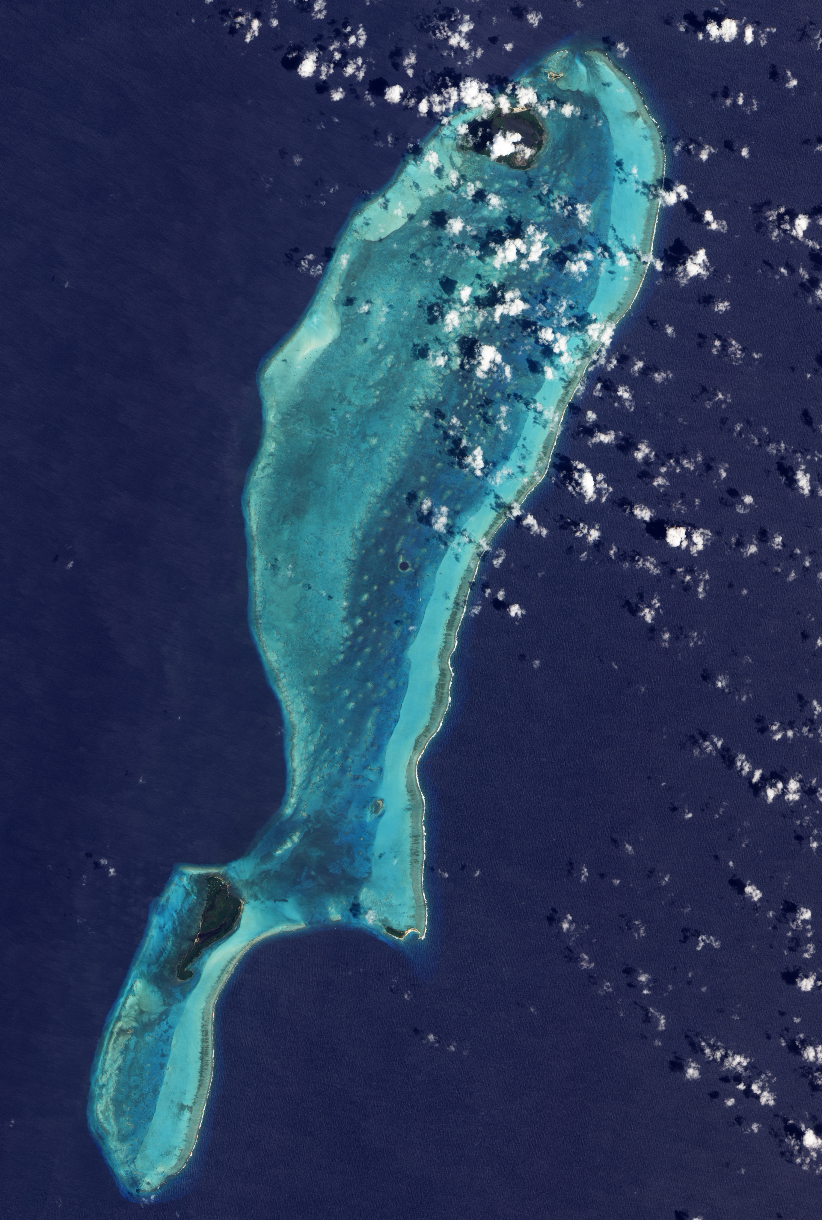
| BeschreibungLighthouse Reef Belize.jpg |
English: NASA image of Lighthouse Reef, Belize, which includes the Great Blue Hole roughly near its center. Created by Jesse Allen, using EO-1 ALI ,data provided courtesy of the NASA EO-1 Team. |
| Datum | |
| Quelle | NASA Earth Observatory |
| Urheber | Jesse Allen |
The Advanced Land Imager (ALI) on NASA’s Earth Observing-1 satellite captured this image of the Great Blue Hole and Lighthouse Reef in the Caribbean Sea on March 24, 2009. The Great Blue Hole appears at the center of the image, surrounded by a ring of lighter color caused by elevated coral. In fact, parts of the ring surrounding this feature actually crest the water surface at low tide, but a layer of shallow water covers most of Lighthouse Reef Atoll. Boats leave tiny white tracks on the nearby water surface, and two boats appear to travel away from the Hole in this image. East of the boats, a broad band of aquamarine indicates an area of especially shallow water along the reef’s margin. Along its easternmost edge, the reef crests the ocean surface, where breaking waves from the Caribbean Sea form a jagged line of white.
Lizenz
| Public domainPublic domainfalsefalse |
| Diese Datei ist gemeinfrei (public domain), da sie von der NASA erstellt worden ist. Die NASA-Urheberrechtsrichtlinie besagt, dass „NASA-Material nicht durch Urheberrecht geschützt ist, wenn es nicht anders angegeben ist“. (NASA-Urheberrechtsrichtlinie-Seite oder JPL Image Use Policy). | ||
 |
Warnung:
|
| Bildnotizen InfoField | Diese Datei ist annotiert: Betrachte diese auf Commons. |
Great Blue Hole (sinkhole)
Saddle Caye
Sandbore Caye
Northern Caye
Long Caye
Hat Caye
Halfmoon Caye
Kurzbeschreibungen
In dieser Datei abgebildete Objekte
Motiv
24. März 2009
Dateiversionen
Klicke auf einen Zeitpunkt, um diese Version zu laden.
| Version vom | Vorschaubild | Maße | Benutzer | Kommentar | |
|---|---|---|---|---|---|
| aktuell | 23:53, 13. Apr. 2009 | | 2.743 × 4.072 (3,88 MB) | Originalwana | {{Information |Description={{en|1=NASA image created by Jesse Allen, using EO-1 ALI data provided courtesy of the NASA EO-1 Team.}} |Source=http://earthobservatory.nasa.gov/IOTD/view.php?id=37741&src=iotdrss |Author=Jesse Allen |Date=2009-03-24 |Permissio |
Dateiverwendung
Die folgenden 3 Seiten verwenden diese Datei:
Globale Dateiverwendung
Die nachfolgenden anderen Wikis verwenden diese Datei:
- Verwendung auf ast.wikipedia.org
- Verwendung auf be.wikipedia.org
- Verwendung auf ca.wikipedia.org
- Verwendung auf ceb.wikipedia.org
- Verwendung auf cs.wikipedia.org
- Verwendung auf en.wikipedia.org
- Verwendung auf es.wikipedia.org
- Verwendung auf hu.wikipedia.org
- Verwendung auf hy.wikipedia.org
- Verwendung auf it.wikipedia.org
- Verwendung auf it.wikivoyage.org
- Verwendung auf ja.wikipedia.org
- Verwendung auf kk.wikipedia.org
- Verwendung auf ko.wikipedia.org
- Verwendung auf mk.wikipedia.org
- Verwendung auf pl.wikipedia.org
- Verwendung auf ro.wikipedia.org
- Verwendung auf ru.wikipedia.org
- Verwendung auf sk.wikipedia.org
- Verwendung auf sl.wikipedia.org
- Verwendung auf sv.wikipedia.org
- Verwendung auf tr.wikipedia.org
- Verwendung auf www.wikidata.org
Metadaten
Diese Datei enthält weitere Informationen (beispielsweise Exif-Metadaten), die in der Regel von der Digitalkamera oder dem verwendeten Scanner stammen. Durch nachträgliche Bearbeitung der Originaldatei können einige Details verändert worden sein.
| Bildtitel | IDL TIFF file |
|---|---|
| Breite | 5.341 px |
| Höhe | 10.621 px |
| Art der Kompression | LZW |
| Pixelzusammensetzung | RGB |
| Kameraausrichtung | Normal |
| Anzahl Komponenten | 3 |
| Horizontale Auflösung | 100 dpi |
| Vertikale Auflösung | 100 dpi |
| Datenausrichtung | Grobformat |
| Software | Adobe Photoshop CS3 Macintosh |
| Speicherzeitpunkt | 11:50, 31. Mär. 2009 |
| Farbraum | Nicht kalibriert |