Datei:Map_of_North_Dakota_NA.png
aus Wikipedia, der freien encyclopedia
Größe dieser Vorschau: 776 × 600 Pixel. Weitere Auflösungen: 311 × 240 Pixel | 621 × 480 Pixel | 994 × 768 Pixel | 1.280 × 989 Pixel | 2.122 × 1.640 Pixel
Originaldatei (2.122 × 1.640 Pixel, Dateigröße: 1,75 MB, MIME-Typ: image/png)
![]()
Diese Datei und die Informationen unter dem roten Trennstrich werden aus dem zentralen Medienarchiv Wikimedia Commons eingebunden.
![]()
Beschreibung
| BeschreibungMap of North Dakota NA.png |
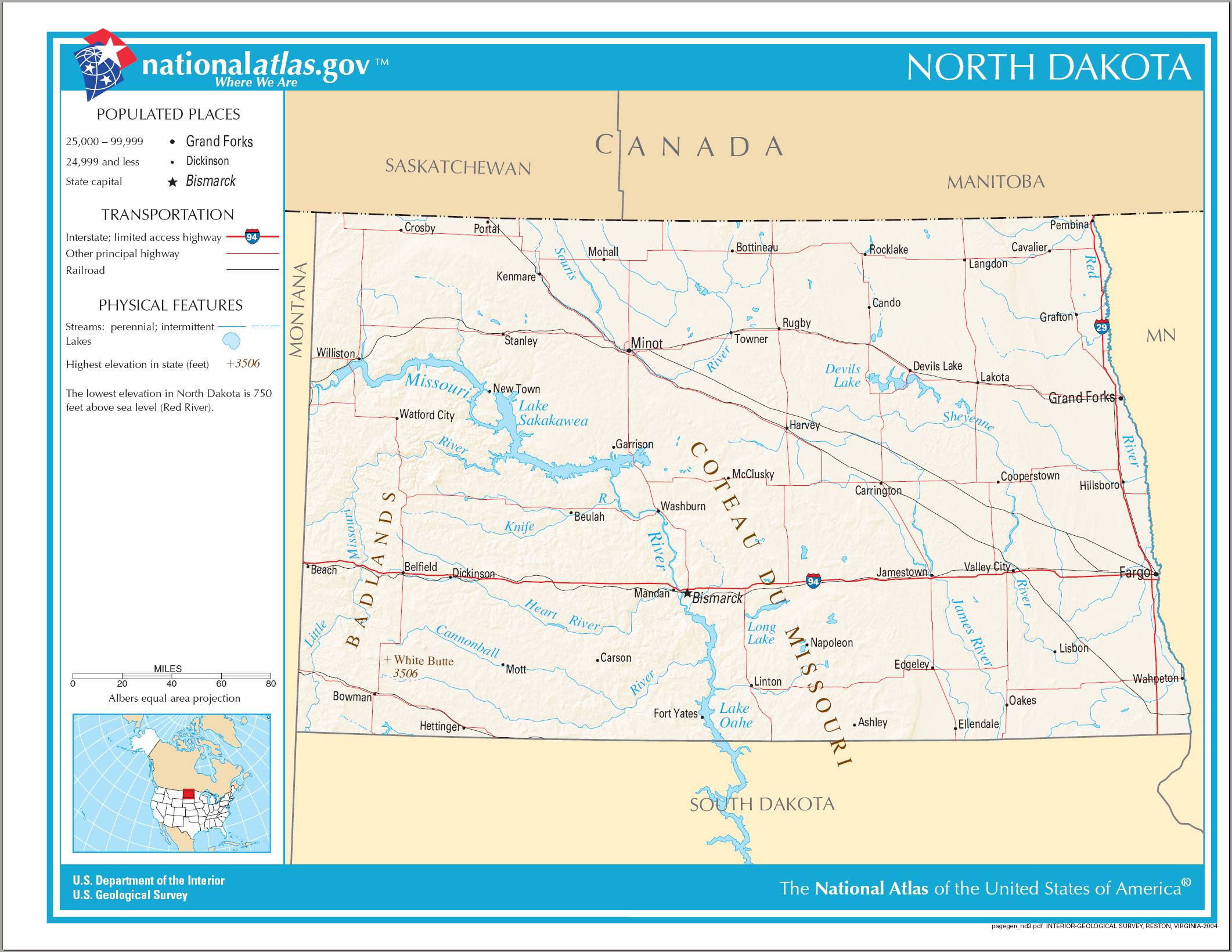
English: Map of North Dakota. |
| Datum | |
| Quelle | National Atlas |
| Urheber |
Bei dieser Datei fehlen Angaben zum Autor.
|
Lizenz
| Public domainPublic domainfalsefalse |
Diese Karte stammt aus einer Ausgabe des National Atlas of the United States. Wie fast alle Arbeiten der Regierung der Vereinigten Staaten sind Arbeiten des National Atlas in den USA gemeinfrei.
Online-Zugang: NationalAtlas.gov | Gedruckte Ausgabe von 1970: Library of Congress, Perry-Castañeda Library čeština | Deutsch | English | français | Bahasa Indonesia | italiano | македонски | മലയാളം | sicilianu | 中文 | 中文(简体) | 中文(繁體) | +/− |
Kurzbeschreibungen
Ergänze eine einzeilige Erklärung, was diese Datei darstellt.
In dieser Datei abgebildete Objekte
Motiv
14. August 2006
Dateiversionen
Klicke auf einen Zeitpunkt, um diese Version zu laden.
| Version vom | Vorschaubild | Maße | Benutzer | Kommentar | |
|---|---|---|---|---|---|
| aktuell | 23:40, 14. Aug. 2006 | | 2.122 × 1.640 (1,75 MB) | Huebi~commonswiki | {{Information| |Description=Map of North Dakota |Source=[http://www.nationalatlas.gov National Atlas] }} Category:Maps of the United States Category:Maps of North Dakota {{PD-USGov-Atlas}} |
Dateiverwendung
Die folgenden 2 Seiten verwenden diese Datei:
Globale Dateiverwendung
Die nachfolgenden anderen Wikis verwenden diese Datei:
- Verwendung auf als.wikipedia.org
- Verwendung auf ca.wikipedia.org
- Verwendung auf en.wikipedia.org
- Verwendung auf hu.wikipedia.org
- Verwendung auf ilo.wikipedia.org
- Verwendung auf incubator.wikimedia.org
- Verwendung auf it.wikipedia.org
- Verwendung auf kn.wikipedia.org
- Verwendung auf lt.wikipedia.org
- Verwendung auf ro.wikipedia.org
- Dakota de Nord
- Categorie:Cioturi stat North Dakota, SUA
- Northwood, Dakota de Nord
- Prefix telefonic 701 (Statele Unite ale Americii)
- Categorie:Teritoriul Dakota
- Listă de oameni din statul Dakota de Nord
- Listă de comitate din statul Dakota de Nord
- Listă de orașe din statul Dakota de Nord
- Comitatul Adams, Dakota de Nord
- Categorie:Zone micropolitane din North Dakota
- Categorie:Baraje din North Dakota
- Categorie:Guvernatori ai statului North Dakota
- Categorie:Istoria statului Dakota de Nord
- Categorie:Dakota de Nord
- Categorie:Oameni din Dakota de Nord după comitat
- Categorie:Clădiri și structuri din statul Dakota de Nord
- Amidon, Dakota de Nord
- Watford City, Dakota de Nord
- Categorie:Formate Dakota de Nord
- Categorie:Localități din Dakota de Nord
- Categorie:Zone metropolitane din Dakota de Nord
- Categorie:Localități din Dakota de Nord după comitat
- Categorie:Comitatul Grand Forks, Dakota de Nord
- Categorie:Comitatul LaMoure, Dakota de Nord
- Mott, Dakota de Nord
- Categorie:Localități din comitatul Hettinger, Dakota de Nord
- Categorie:Geografia comitatului Hettinger, Dakota de Nord
- Categorie:Localități din comitatul Eddy, Dakota de Nord
- Categorie:Comitatul Slope, Dakota de Nord
- Categorie:Membri ai legislaturii statului Dakota de Nord
- Categorie:Absolvenți din Dakota de Nord după instituția de învățământ superior
- Categorie:Educația în Dakota de Nord
Weitere globale Verwendungen dieser Datei anschauen.
Abgerufen von „https://de.wikipedia.org/wiki/Datei:Map_of_North_Dakota_NA.png“