File:2011-Sendai-Tsunami-DART-21413-AB.png
From Wikipedia, the free encyclopedia
Size of this preview: 800 × 565 pixels. Other resolutions: 320 × 226 pixels | 640 × 452 pixels | 1,024 × 724 pixels | 1,280 × 905 pixels | 2,560 × 1,810 pixels | 3,507 × 2,479 pixels.
Original file (3,507 × 2,479 pixels, file size: 1.09 MB, MIME type: image/png)
| This is a file from the Wikimedia Commons. Information from its description page there is shown below. Commons is a freely licensed media file repository. You can help. |

|
This graph image could be re-created using vector graphics as an SVG file. This has several advantages; see Commons:Media for cleanup for more information. If an SVG form of this image is available, please upload it and afterwards replace this template with
{{vector version available|new image name}}.
It is recommended to name the SVG file “2011-Sendai-Tsunami-DART-21413-AB.svg”—then the template Vector version available (or Vva) does not need the new image name parameter. |
Summary
| Description2011-Sendai-Tsunami-DART-21413-AB.png |
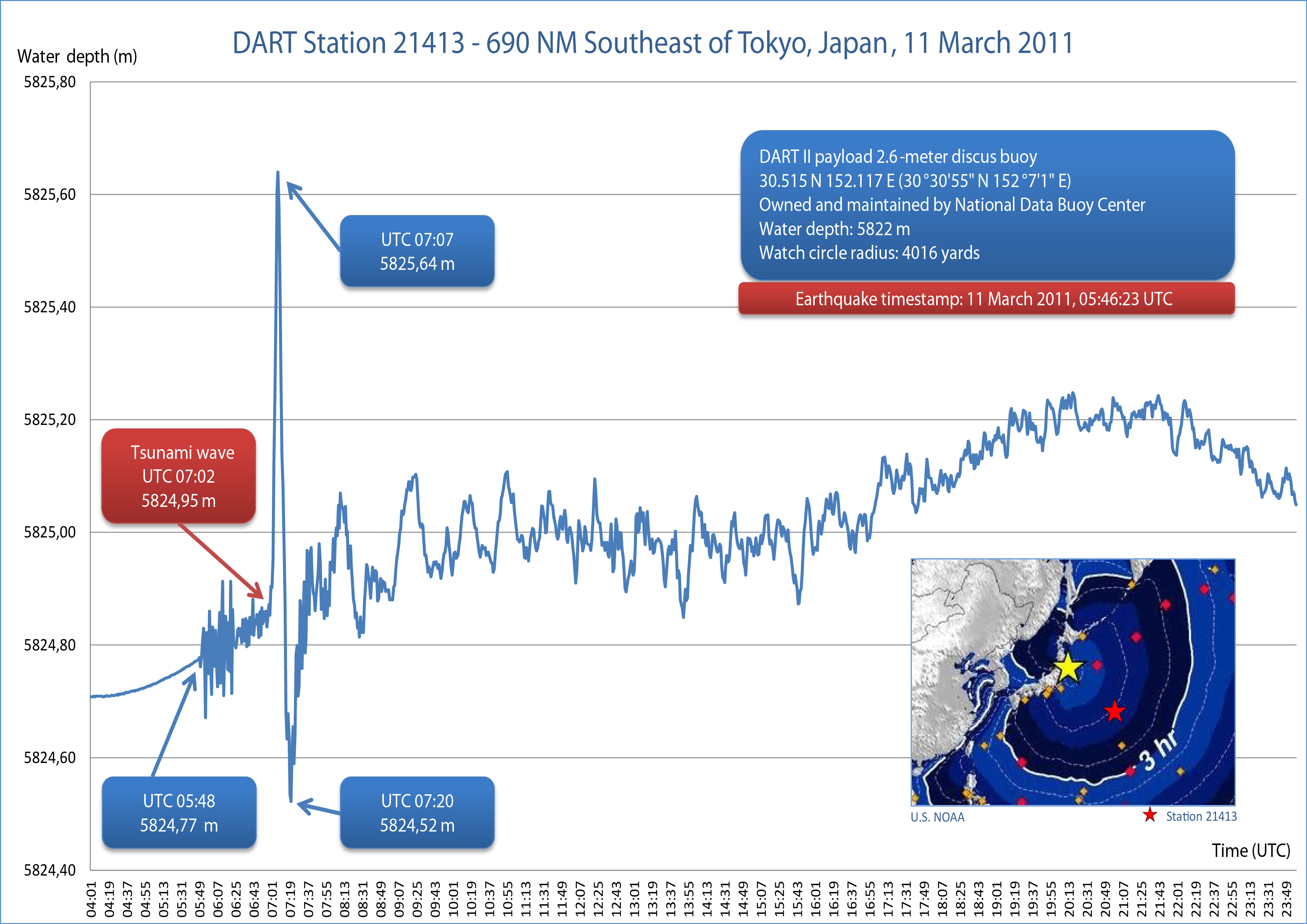
English: Water Column Height at DART II Station 21413 during 2011 Tōhoku earthquake and tsunami on March 11, 2011
日本語: 深海評価津波報告 (DART) ブイ 21413 が計測した、東北地方太平洋沖地震が発生した2011年3月11日の水柱高 |
| Date | |
| Source | Own work |
| Author | Chepry 💬 (Andrzej Barabasz) 📷 🇵🇱 |
| Camera location | 30° 30′ 54″ N, 152° 07′ 01.2″ E | View this and other nearby images on: OpenStreetMap |
|---|
Licensing
I, the copyright holder of this work, hereby publish it under the following licenses:
This file is licensed under the Creative Commons Attribution-Share Alike 3.0 Unported license.
- You are free:
- to share – to copy, distribute and transmit the work
- to remix – to adapt the work
- Under the following conditions:
- attribution – You must give appropriate credit, provide a link to the license, and indicate if changes were made. You may do so in any reasonable manner, but not in any way that suggests the licensor endorses you or your use.
- share alike – If you remix, transform, or build upon the material, you must distribute your contributions under the same or compatible license as the original.

|
Permission is granted to copy, distribute and/or modify this document under the terms of the GNU Free Documentation License, Version 1.2 or any later version published by the Free Software Foundation; with no Invariant Sections, no Front-Cover Texts, and no Back-Cover Texts. A copy of the license is included in the section entitled GNU Free Documentation License.http://www.gnu.org/copyleft/fdl.htmlGFDLGNU Free Documentation Licensetruetrue |
You may select the license of your choice.
Captions
Add a one-line explanation of what this file represents
Items portrayed in this file
depicts
30°30'54"N, 152°7'1"E
13 March 2011
image/png
dacff0654ab627d5556a8d3d0ee189725d46a25b
1,139,872 byte
2,479 pixel
3,507 pixel
File history
Click on a date/time to view the file as it appeared at that time.
| Date/Time | Thumbnail | Dimensions | User | Comment | |
|---|---|---|---|---|---|
| current | 21:37, 13 March 2011 | | 3,507 × 2,479 (1.09 MB) | Chepry | proof (minor change) |
| 21:09, 13 March 2011 |  | 3,507 × 2,479 (1.08 MB) | Chepry | {{Information |Description ={{en|1=Be sson}} |Source ={{own}} |Author =Chepry |Date =2011-03-13 |Permission = |other_versions = }} {{location dec|30.515|152.117}} |
File usage
The following pages on the English Wikipedia use this file (pages on other projects are not listed):
Global file usage
The following other wikis use this file:
- Usage on da.wikipedia.org
- Usage on en.wikibooks.org
- Usage on ms.wikipedia.org
- Usage on nl.wikipedia.org
- Usage on no.wikipedia.org
Metadata
This file contains additional information, probably added from the digital camera or scanner used to create or digitize it.
If the file has been modified from its original state, some details may not fully reflect the modified file.
| Horizontal resolution | 118.11 dpc |
|---|---|
| Vertical resolution | 118.11 dpc |
| Software used |