File:Aerial_view_of_Rose_Bowl_Cricket_Ground_-_geograph.org.uk_-_690412.jpg
From Wikipedia, the free encyclopedia
No higher resolution available.
Aerial_view_of_Rose_Bowl_Cricket_Ground_-_geograph.org.uk_-_690412.jpg (640 × 525 pixels, file size: 82 KB, MIME type: image/jpeg)
| This is a file from the Wikimedia Commons. Information from its description page there is shown below. Commons is a freely licensed media file repository. You can help. |
Summary
| DescriptionAerial view of Rose Bowl Cricket Ground - geograph.org.uk - 690412.jpg |
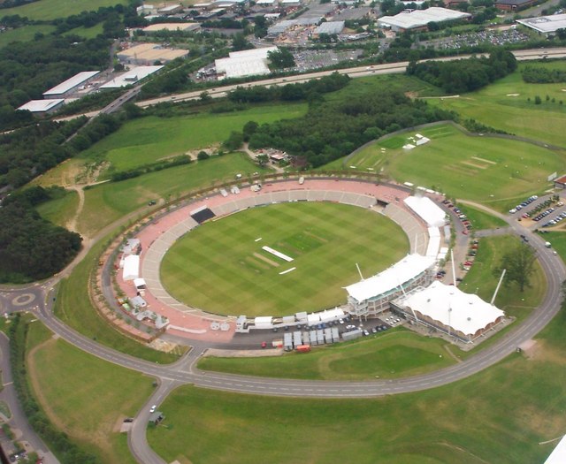
English: Aerial view of Rose Bowl Cricket Ground Taken during a birthday flying lesson.Courtesy of my son. |
| Date | |
| Source | From geograph.org.uk |
| Author | Colin Babb |
| Attribution (required by the license) InfoField | Colin Babb / Aerial view of Rose Bowl Cricket Ground / |
InfoField | Colin Babb / Aerial view of Rose Bowl Cricket Ground |
| Camera location | 50° 55′ 27″ N, 1° 19′ 20″ W | View this and other nearby images on: OpenStreetMap |
|---|
| Object location | 50° 55′ 27″ N, 1° 19′ 20″ W | View this and other nearby images on: OpenStreetMap |
|---|
Licensing

|
This image was taken from the Geograph project collection. See this photograph's page on the Geograph website for the photographer's contact details. The copyright on this image is owned by Colin Babb and is licensed for reuse under the Creative Commons Attribution-ShareAlike 2.0 license.
|
This file is licensed under the Creative Commons Attribution-Share Alike 2.0 Generic license.
Attribution: Colin Babb
- You are free:
- to share – to copy, distribute and transmit the work
- to remix – to adapt the work
- Under the following conditions:
- attribution – You must give appropriate credit, provide a link to the license, and indicate if changes were made. You may do so in any reasonable manner, but not in any way that suggests the licensor endorses you or your use.
- share alike – If you remix, transform, or build upon the material, you must distribute your contributions under the same or compatible license as the original.
Captions
Add a one-line explanation of what this file represents
Items portrayed in this file
depicts
some value
5 June 2004
50°55'26.98"N, 1°19'19.56"W
50°55'26.98"N, 1°19'19.56"W
image/jpeg
7bf3ffa66f5d2e93835f871e25672ab71a71e812
84,420 byte
525 pixel
640 pixel
File history
Click on a date/time to view the file as it appeared at that time.
| Date/Time | Thumbnail | Dimensions | User | Comment | |
|---|---|---|---|---|---|
| current | 04:14, 8 February 2011 | | 640 × 525 (82 KB) | GeographBot | == {{int:filedesc}} == {{Information |description={{en|1=Aerial view of Rose Bowl Cricket Ground Taken during a birthday flying lesson.Courtesy of my son.}} |date=2004-06-05 |source=From [http://www.geograph.org.uk/photo/690412 geograph.org.uk] |author=[h |
File usage
The following pages on the English Wikipedia use this file (pages on other projects are not listed):
Global file usage
The following other wikis use this file:
- Usage on ta.wikipedia.org
- Usage on ur.wikipedia.org