File:Africa-regions.png
From Wikipedia, the free encyclopedia
No higher resolution available.
Africa-regions.png (360 × 392 pixels, file size: 8 KB, MIME type: image/png)
| This is a file from the Wikimedia Commons. Information from its description page there is shown below. Commons is a freely licensed media file repository. You can help. |
Summary
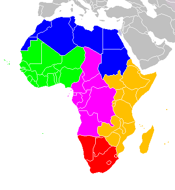
Africa: subregions as delineated by United Nations geographic classification scheme:
Licensing
I, the copyright holder of this work, hereby publish it under the following licenses:

|
Permission is granted to copy, distribute and/or modify this document under the terms of the GNU Free Documentation License, Version 1.2 or any later version published by the Free Software Foundation; with no Invariant Sections, no Front-Cover Texts, and no Back-Cover Texts. A copy of the license is included in the section entitled GNU Free Documentation License.http://www.gnu.org/copyleft/fdl.htmlGFDLGNU Free Documentation Licensetruetrue |
| This file is licensed under the Creative Commons Attribution-Share Alike 3.0 Unported license. | ||
| ||
| This licensing tag was added to this file as part of the GFDL licensing update.http://creativecommons.org/licenses/by-sa/3.0/CC BY-SA 3.0Creative Commons Attribution-Share Alike 3.0truetrue |
This file is licensed under the Creative Commons Attribution-Share Alike 2.5 Generic, 2.0 Generic and 1.0 Generic license.
- You are free:
- to share – to copy, distribute and transmit the work
- to remix – to adapt the work
- Under the following conditions:
- attribution – You must give appropriate credit, provide a link to the license, and indicate if changes were made. You may do so in any reasonable manner, but not in any way that suggests the licensor endorses you or your use.
- share alike – If you remix, transform, or build upon the material, you must distribute your contributions under the same or compatible license as the original.
You may select the license of your choice.

|
File:Africa map regions.svg is a vector version of this file. It should be used in place of this PNG file when not inferior.
File:Africa-regions.png → File:Africa map regions.svg
For more information, see Help:SVG.
|
 |
Captions
Add a one-line explanation of what this file represents
Items portrayed in this file
depicts
image/png
99e24847dfc7d308c007e19664bcafb5a4453b92
7,959 byte
392 pixel
360 pixel
File history
Click on a date/time to view the file as it appeared at that time.
| Date/Time | Thumbnail | Dimensions | User | Comment | |
|---|---|---|---|---|---|
| current | 02:02, 1 June 2018 | | 360 × 392 (8 KB) | Vesperius | Reverted to version as of 18:36, 28 May 2018 (UTC) (Most definitions of the regions include the Horn of Africa as part of East Africa, so I'm reverting this back) |
| 18:37, 28 May 2018 |  | 360 × 392 (10 KB) | Vesperius | Reverted to version as of 18:25, 28 May 2018 (UTC) (Messed up, the purple indicating the Horn of Africa didn't show up for me) | |
| 18:36, 28 May 2018 |  | 360 × 392 (8 KB) | Vesperius | Reverted to version as of 01:04, 16 May 2018 (UTC) | |
| 18:25, 28 May 2018 |  | 360 × 392 (10 KB) | Vesperius | Reverted to version as of 18:57, 17 March 2018 (UTC) | |
| 01:04, 16 May 2018 |  | 360 × 392 (8 KB) | Dwo | Reverted to version as of 08:22, 30 August 2015 (UTC) | |
| 18:57, 17 March 2018 |  | 360 × 392 (10 KB) | Maphobbyist | Montenegro border | |
| 08:22, 30 August 2015 |  | 360 × 392 (8 KB) | Wiki-Zyron | Reverted to version as of 00:23, 20 December 2012 - Reverted to the last version before someone inexplicably moved Zimbabwe to Southern Africa. Eastern Africa is the correct region - [http://unstats.un.org/unsd/methods/m49/m49regin.htm#africa] | |
| 05:04, 21 April 2015 |  | 360 × 392 (16 KB) | TAKASUGI Shinji | Corrected the color of Zimbabwe | |
| 15:16, 18 December 2014 |  | 360 × 392 (17 KB) | Hybscher | wrong colors | |
| 22:39, 22 November 2014 |  | 2,000 × 2,050 (342 KB) | Andrew J.Kurbiko | pp |
File usage
The following pages on the English Wikipedia use this file (pages on other projects are not listed):
- A10 highway (Nigeria)
- A3 highway (Lesotho)
- A3 motorway (Tunisia)
- A4 motorway (Tunisia)
- A6 road (Zimbabwe)
- Apapa–Oworonshoki Expressway
- Ashmun Street
- Asokwa Interchange
- Avenida 4 de Fevereiro
- B10 road (Namibia)
- B11 road (Namibia)
- B14 road (Namibia)
- B15 road (Namibia)
- B8 road (Namibia)
- C12 road (Namibia)
- C13 road (Namibia)
- C14 road (Namibia)
- C15 road (Namibia)
- C16 road (Namibia)
- C17 road (Namibia)
- C18 road (Namibia)
- C25 road (Namibia)
- C26 road (Namibia)
- C28 road (Namibia)
- Cairo Road
- Cairo–Dakar Highway
- Danquah Circle
- Dschang bus-truck crash
- Independence Avenue (Windhoek)
- Kwame Nkrumah Interchange
- Lists of cities in Africa
- MR3 road
- MR7 road
- MR8 road
- Main roads (Lesotho)
- Mobolaji Bank Anthony Way
- N'Djamena–Djibouti Highway
- N10 road (Ghana)
- N1 road (Gabon)
- N1 road (Guinea)
- N1 road (Senegal)
- N2 road (Gabon)
- N2 road (Republic of the Congo)
- N2 road (Senegal)
- N2 road (Zimbabwe)
- N3 road (Gabon)
- N3 road (Senegal)
- N4 road (Gabon)
- N4 road (Ghana)
- N5 road (Gabon)
- N5 road (Senegal)
- N6 road (Gabon)
- N6 road (Senegal)
- N7 road (Gabon)
- N7 road (Senegal)
- National Highway 11 (Djibouti)
- National Highway 14 (Djibouti)
- National Highway 15 (Djibouti)
- National Highway 1 (Djibouti)
- National Highway 2 (Djibouti)
- National Highway 3 (Djibouti)
- National Highway 4 (Djibouti)
- National Highway 5 (Djibouti)
- National Highway 6 (Djibouti)
- National Highway 7 (Djibouti)
- National Highway 8 (Djibouti)
- National Highway 9 (Djibouti)
- Numbered routes in Lesotho
- Portuguese Africans
- RIP73 (Madagascar)
- RNIE 1
- RNIE 2
- RNIE 3
- RNIE 4
- RNIE 5
- RNIE 6
- RNIE 7
- Route nationale 1 (Niger)
- Route nationale 4 (Madagascar)
- Route nationale 8a (Madagascar)
- Rua Libertadores de África
- Sam Nujoma Street
- Southern Africa
- Speed limits in Tunisia
- Standard Encyclopaedia of Southern Africa
- Strait of Sicily Tunnel
- Tamale-Bolgatanga Highway
- United Nations geoscheme
- United Nations geoscheme for Africa
- Walvis Bay-Ndola-Lubumbashi Development Road
- User:ArminHammer
- User:Donbert/motherafrica
- User:Donbert/userboxes
- User:R4000/Africa(Alt)
- User:Ziraro
- User talk:Khajidha/Archive1
- Template:Africa-road-stub
- Portal:Africa/Countries
- Portal:Africa/Countries/Map
Global file usage
The following other wikis use this file:
- Usage on af.wikipedia.org
- Usage on anp.wikipedia.org
- Usage on ar.wikipedia.org
- Usage on arz.wikipedia.org
- Usage on avk.wikipedia.org
- Usage on azb.wikipedia.org
- Usage on ba.wikipedia.org
- Usage on bg.wikipedia.org
- Usage on blk.wikipedia.org
- Usage on bn.wikipedia.org
- Usage on br.wikipedia.org
- Usage on bxr.wikipedia.org
- Usage on ca.wikipedia.org
- Usage on cy.wikipedia.org
- Usage on de.wikipedia.org
- Usage on el.wikipedia.org
- Usage on en.wiktionary.org
- Usage on eo.wikipedia.org
- Usage on es.wikipedia.org
- Usage on es.wikibooks.org
- Usage on et.wikipedia.org
- Usage on fa.wikipedia.org
- Usage on fi.wikipedia.org
- Usage on fr.wikipedia.org
View more global usage of this file.
Retrieved from "https://en.wikipedia.org/wiki/File:Africa-regions.png"