File:Amazonrivermap.png
From Wikipedia, the free encyclopedia
Size of this preview: 600 × 600 pixels. Other resolutions: 240 × 240 pixels | 480 × 480 pixels | 1,000 × 1,000 pixels.
Original file (1,000 × 1,000 pixels, file size: 551 KB, MIME type: image/png)
| This is a file from the Wikimedia Commons. Information from its description page there is shown below. Commons is a freely licensed media file repository. You can help. |

|
File:Amazonrivermap.svg is a vector version of this file. It should be used in place of this PNG file when not inferior.
File:Amazonrivermap.png → File:Amazonrivermap.svg
For more information, see Help:SVG.
|
 |
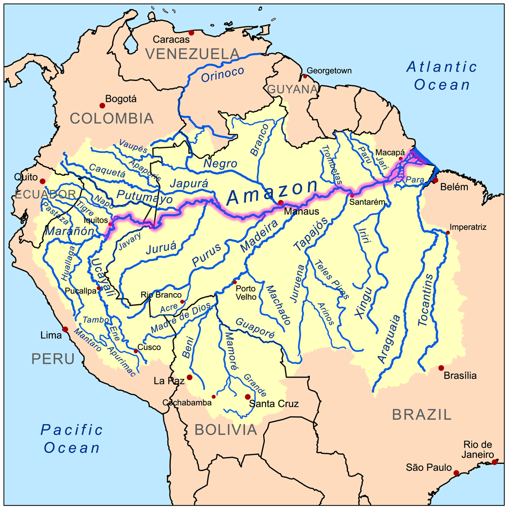
| DescriptionAmazonrivermap.png | This is a map of the Amazon River drainage basin with the Amazon River highlighted. |
| Date | |
| Source | Own work using Digital Chart of the World and GTOPO data. |
| Author | Kmusser |
I, the copyright holder of this work, hereby publish it under the following license:
This file is licensed under the Creative Commons Attribution-Share Alike 3.0 Unported license.
- You are free:
- to share – to copy, distribute and transmit the work
- to remix – to adapt the work
- Under the following conditions:
- attribution – You must give appropriate credit, provide a link to the license, and indicate if changes were made. You may do so in any reasonable manner, but not in any way that suggests the licensor endorses you or your use.
- share alike – If you remix, transform, or build upon the material, you must distribute your contributions under the same or compatible license as the original.
Captions
Add a one-line explanation of what this file represents
Items portrayed in this file
depicts
8 September 2008
image/png
20f81886dee6b5a6eb5a0703f8cbe92ef736e1dd
564,313 byte
1,000 pixel
1,000 pixel
File history
Click on a date/time to view the file as it appeared at that time.
| Date/Time | Thumbnail | Dimensions | User | Comment | |
|---|---|---|---|---|---|
| current | 19:02, 19 December 2022 | | 1,000 × 1,000 (551 KB) | Italyoz484 | |
| 17:04, 1 September 2022 |  | 1,000 × 1,000 (583 KB) | Wolf170278 | Tocantins doesn't belong to the amazon river basin | |
| 17:15, 8 September 2008 |  | 1,000 × 1,000 (551 KB) | Kmusser | {{Information |Description=This is a map of the Amazon River drainage basin with the Amazon River highlighted. |Source=Own work using http://www.maproom.psu.edu/dcw/ Digital Chart of the World and [[http://edc.usgs.gov/products/el |
File usage
The following pages on the English Wikipedia use this file (pages on other projects are not listed):
Global file usage
The following other wikis use this file:
- Usage on da.wikipedia.org
- Usage on de.wikipedia.org
- Usage on de.wikinews.org
- Usage on he.wikipedia.org
- Usage on ko.wikipedia.org
- Usage on lez.wikipedia.org
- Usage on nn.wikipedia.org
- Usage on no.wikipedia.org
Metadata
This file contains additional information, probably added from the digital camera or scanner used to create or digitize it.
If the file has been modified from its original state, some details may not fully reflect the modified file.
| Software used |
|---|
Retrieved from "https://en.wikipedia.org/wiki/File:Amazonrivermap.png"