File:Arnhem_Land_map.png
From Wikipedia, the free encyclopedia
Size of this preview: 800 × 584 pixels. Other resolutions: 320 × 233 pixels | 640 × 467 pixels | 1,024 × 747 pixels | 1,280 × 934 pixels | 1,615 × 1,178 pixels.
Original file (1,615 × 1,178 pixels, file size: 1.45 MB, MIME type: image/png)
| This is a file from the Wikimedia Commons. Information from its description page there is shown below. Commons is a freely licensed media file repository. You can help. |
Summary
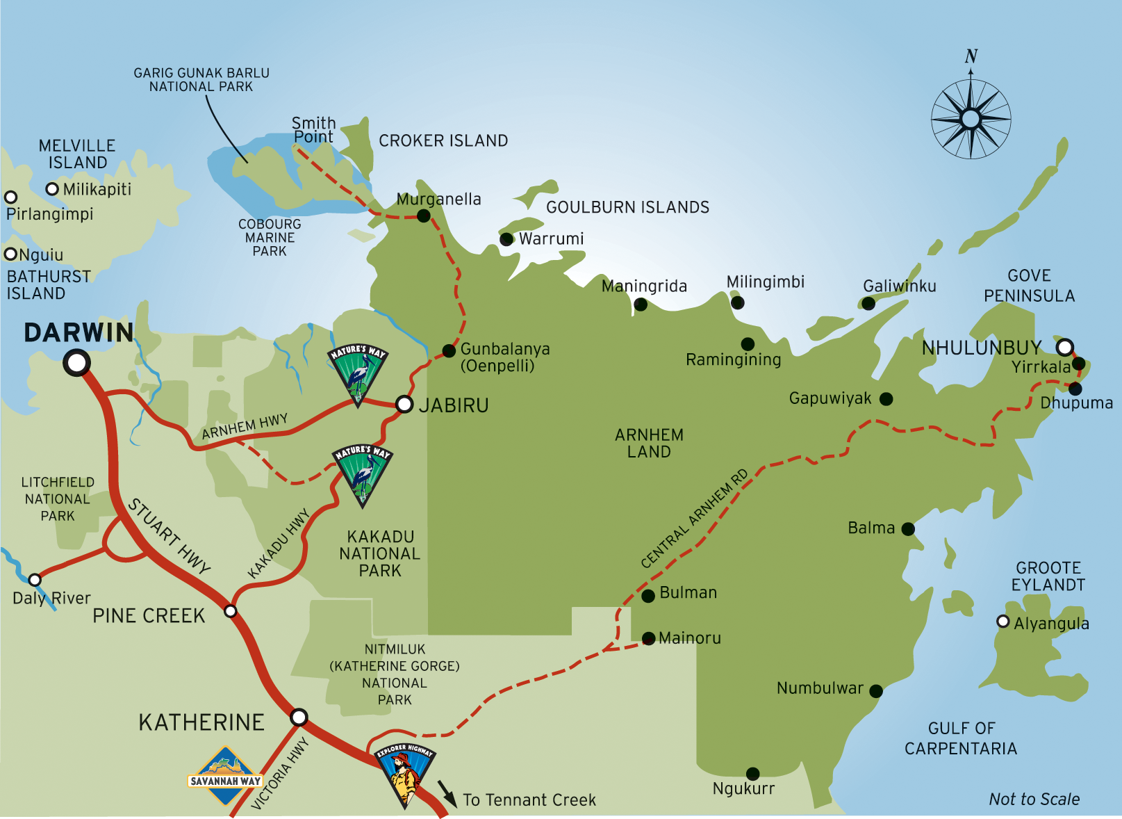
| DescriptionArnhem Land map.png |
English: Map of Arnhem Land, Northern Territory |
| Date | |
| Source | Nigel Malone |
| Author | Nigel Malone |
Licensing
This file is licensed under the Creative Commons Attribution-Share Alike 4.0 International, 3.0 Unported, 2.5 Generic, 2.0 Generic and 1.0 Generic license.
- You are free:
- to share – to copy, distribute and transmit the work
- to remix – to adapt the work
- Under the following conditions:
- attribution – You must give appropriate credit, provide a link to the license, and indicate if changes were made. You may do so in any reasonable manner, but not in any way that suggests the licensor endorses you or your use.
- share alike – If you remix, transform, or build upon the material, you must distribute your contributions under the same or compatible license as the original.
Original upload log
| This file was imported from Wikivoyage WTS. |
The original description page was here. All following user names refer to wts.wikivoyage-old.
- 2008-11-24 06:26 (WT-shared) Lex[dead link] 1615×1178 (1521510 bytes) {{Imagecredit|credit=Nigel Malone|captureDate=2005|location=NT|source=Nigel Malone|caption=Map of Arnhem Land|description=Map of Arnhem Land (Import from wikitravel.org/shared)
Captions
Add a one-line explanation of what this file represents
Items portrayed in this file
depicts
2005
image/png
1d23d9643a61e2a2133907e471ccb6f5180a13f1
1,521,510 byte
1,178 pixel
1,615 pixel
File history
Click on a date/time to view the file as it appeared at that time.
| Date/Time | Thumbnail | Dimensions | User | Comment | |
|---|---|---|---|---|---|
| current | 21:53, 17 November 2012 | | 1,615 × 1,178 (1.45 MB) | MGA73bot2 | {{BotMoveToCommons|wts.oldwikivoyage|year={{subst:CURRENTYEAR}}|month={{subst:CURRENTMONTHNAME}}|day={{subst:CURRENTDAY}}}} == {{int:filedesc}} == {{Information |description=Map of Arnhem Land. Map of Arnhem Land, Northern Territory * Map of: Northern ... |
File usage
The following pages on the English Wikipedia use this file (pages on other projects are not listed):
Global file usage
The following other wikis use this file:
- Usage on en.wikivoyage.org
- Usage on hu.wikipedia.org
- Usage on kk.wikipedia.org
- Usage on ky.wikipedia.org
- Usage on uk.wikipedia.org
Metadata
This file contains additional information, probably added from the digital camera or scanner used to create or digitize it.
If the file has been modified from its original state, some details may not fully reflect the modified file.
| Horizontal resolution | 137.8 dpc |
|---|---|
| Vertical resolution | 137.8 dpc |
Retrieved from "https://en.wikipedia.org/wiki/File:Arnhem_Land_map.png"