File:Arran_satellite.jpg
From Wikipedia, the free encyclopedia
Size of this preview: 396 × 599 pixels. Other resolutions: 158 × 240 pixels | 317 × 480 pixels | 752 × 1,138 pixels.
Original file (752 × 1,138 pixels, file size: 144 KB, MIME type: image/jpeg)
| This is a file from the Wikimedia Commons. Information from its description page there is shown below. Commons is a freely licensed media file repository. You can help. |
Summary
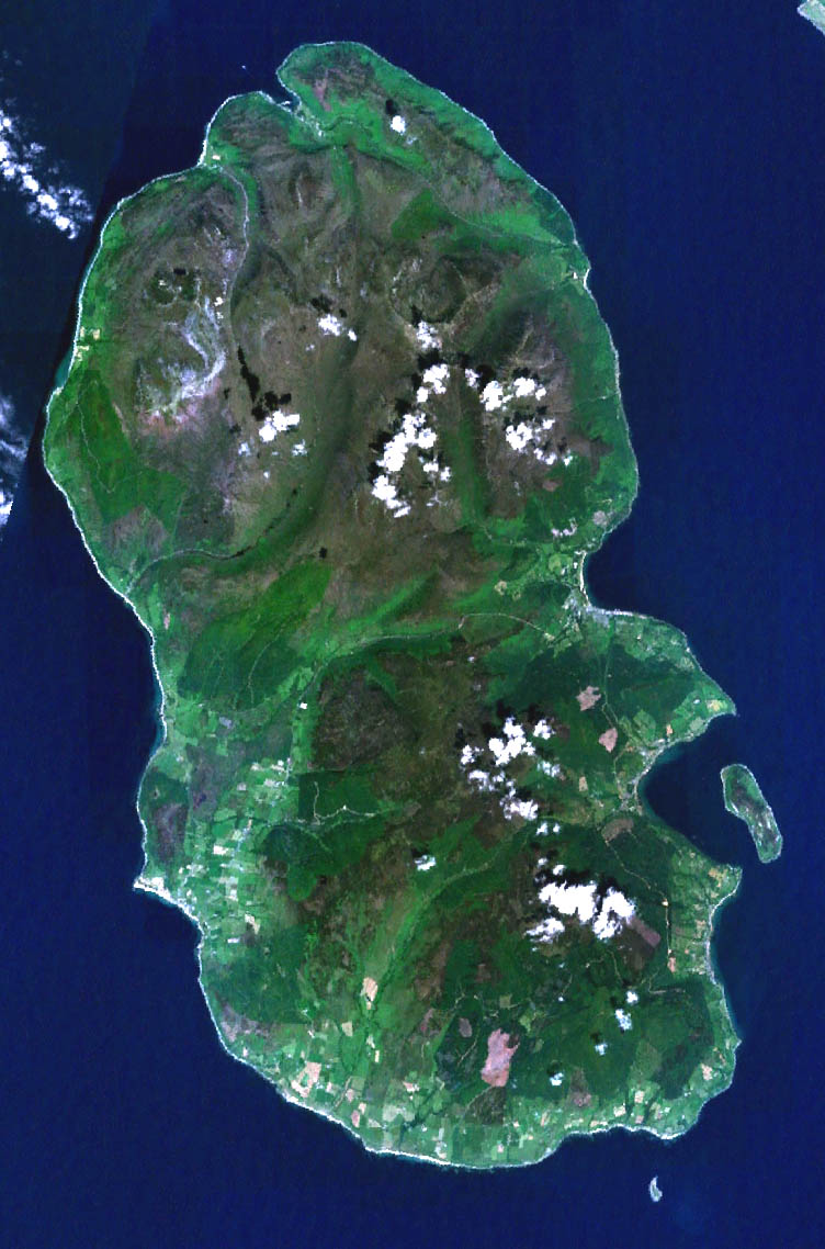
| DescriptionArran satellite.jpg |
English: Landsat image of the Isle of Arran in Scotland. |
||
| Date | 4 July 2005 (original upload date) | ||
| Source |
NASA Landsat image. Made with World Wind. |
||
| Author | NASA | ||
| Other versions |
|

Licensing
| Public domainPublic domainfalsefalse |
| This image is in the public domain because it is a screenshot from NASA’s globe software World Wind using a public domain layer, such as Blue Marble, MODIS, Landsat, SRTM, USGS or GLOBE.
العربيَّة | English | فارسی | français | עברית | македонски | മലയാളം | Nederlands | русский | 中文(中国大陆) | +/− |
 |
Captions
Add a one-line explanation of what this file represents
Items portrayed in this file
depicts
image/jpeg
2b426e880f3e322faaced67cc17e6111658dc1f5
147,062 byte
1,138 pixel
752 pixel
File history
Click on a date/time to view the file as it appeared at that time.
| Date/Time | Thumbnail | Dimensions | User | Comment | |
|---|---|---|---|---|---|
| current | 05:45, 11 May 2006 | | 752 × 1,138 (144 KB) | 汲平 | This came from en:Image:Arran satellite.jpg posted by en:User:Finlay McWalter on July 4, 2005 under PD-USGov-NASA. The original page says "NASA Landsat image of the Isle of Arran in Scotland. Made with World Wind." |
File usage
The following pages on the English Wikipedia use this file (pages on other projects are not listed):
- Arran distillery
- Beinn Bharrain
- Beinn Tarsuinn (Corbett)
- Blackwaterfoot
- Brodick
- Brodick Castle
- Caisteal Abhail
- Catacol
- Cladach
- Corrie, Arran
- Creag Ghlas Laggan
- Cìr Mhòr
- Dippen, Arran
- Eas a' Chrannaig
- Goat Fell
- Holy Island, Firth of Clyde
- Isle of Arran
- Kildonan, Arran
- Kilmory, Arran
- Lagg, Arran
- Lamlash
- List of places in North Ayrshire
- Lochranza
- Lochranza Castle
- Machrie
- Pirnmill
- Pladda
- Sannox
- Shiskine
- Sleeping Warrior
- Sliddery
- The Arran Banner
- Tighvein
- Whitefarland
- Whiting Bay
- Template:Isle of Arran
Global file usage
The following other wikis use this file:
- Usage on ar.wikipedia.org
- Usage on az.wikipedia.org
- Usage on be.wikipedia.org
- Usage on br.wikipedia.org
- Usage on de.wikipedia.org
- Usage on el.wikipedia.org
- Usage on es.wikipedia.org
- Usage on fr.wikipedia.org
- Usage on gl.wikipedia.org
- Usage on hu.wikipedia.org
- Usage on it.wikipedia.org
- Usage on ja.wikipedia.org
- Usage on mt.wikipedia.org
- Usage on no.wikipedia.org
- Usage on pl.wikipedia.org
- Usage on simple.wikipedia.org
- Usage on sk.wikipedia.org
- Usage on sr.wikipedia.org
Metadata
This file contains additional information, probably added from the digital camera or scanner used to create or digitize it.
If the file has been modified from its original state, some details may not fully reflect the modified file.
| Orientation | Normal |
|---|---|
| Horizontal resolution | 72 dpi |
| Vertical resolution | 72 dpi |
| Software used | Adobe Photoshop 7.0 |
| File change date and time | 13:56, 4 July 2005 |
| Color space | Uncalibrated |
Retrieved from "https://en.wikipedia.org/wiki/File:Arran_satellite.jpg"