File:Byfleet,_The_Village_Hall_-_geograph.org.uk_-_812136.jpg
From Wikipedia, the free encyclopedia
No higher resolution available.
Byfleet,_The_Village_Hall_-_geograph.org.uk_-_812136.jpg (640 × 480 pixels, file size: 102 KB, MIME type: image/jpeg)
| This is a file from the Wikimedia Commons. Information from its description page there is shown below. Commons is a freely licensed media file repository. You can help. |
Summary
| DescriptionByfleet, The Village Hall - geograph.org.uk - 812136.jpg |
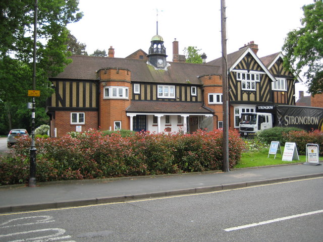
English: Byfleet: The Village Hall As village halls go this one is quite magnificent! It was built to commemorate the Diamond Jubilee, in 1897, of Queen Victoria's reign, but was actually opened in 1898. The half-timbered building has castellated towers either side of the entrance, and a clock turret and cupola. It is on the south side of the High Road. |
| Date | |
| Source | From geograph.org.uk |
| Author | Nigel Cox |
| Attribution (required by the license) InfoField | Nigel Cox / Byfleet: The Village Hall / |
InfoField | Nigel Cox / Byfleet: The Village Hall |
| Camera location | 51° 20′ 19″ N, 0° 28′ 41″ W | View this and other nearby images on: OpenStreetMap |
|---|
| Object location | 51° 20′ 19″ N, 0° 28′ 41″ W | View this and other nearby images on: OpenStreetMap |
|---|
Licensing

|
This image was taken from the Geograph project collection. See this photograph's page on the Geograph website for the photographer's contact details. The copyright on this image is owned by Nigel Cox and is licensed for reuse under the Creative Commons Attribution-ShareAlike 2.0 license.
|
This file is licensed under the Creative Commons Attribution-Share Alike 2.0 Generic license.
Attribution: Nigel Cox
- You are free:
- to share – to copy, distribute and transmit the work
- to remix – to adapt the work
- Under the following conditions:
- attribution – You must give appropriate credit, provide a link to the license, and indicate if changes were made. You may do so in any reasonable manner, but not in any way that suggests the licensor endorses you or your use.
- share alike – If you remix, transform, or build upon the material, you must distribute your contributions under the same or compatible license as the original.
Captions
Add a one-line explanation of what this file represents
Items portrayed in this file
depicts
some value
20 May 2008
51°20'19.0"N, 0°28'40.8"W
51°20'19.0"N, 0°28'40.8"W
image/jpeg
c941916295c75e371441adb1e81bdea0d33a3dd9
104,364 byte
480 pixel
640 pixel
File history
Click on a date/time to view the file as it appeared at that time.
| Date/Time | Thumbnail | Dimensions | User | Comment | |
|---|---|---|---|---|---|
| current | 11:33, 20 February 2011 | | 640 × 480 (102 KB) | GeographBot | == {{int:filedesc}} == {{Information |description={{en|1=Byfleet: The Village Hall As village halls go this one is quite magnificent! It was built to commemorate the Diamond Jubilee, in 1897, of Queen Victoria's reign, but was actually opened in 1898. The |
File usage
The following pages on the English Wikipedia use this file (pages on other projects are not listed):
Global file usage
The following other wikis use this file:
- Usage on azb.wikipedia.org
- Usage on ceb.wikipedia.org
- Usage on fa.wikipedia.org
- Usage on fr.wikipedia.org
- Usage on lld.wikipedia.org
- Usage on nl.wikipedia.org
- Usage on ro.wikipedia.org
- Usage on sv.wikipedia.org
- Usage on ur.wikipedia.org
- Usage on www.wikidata.org
- Usage on zh-min-nan.wikipedia.org
Metadata
This file contains additional information, probably added from the digital camera or scanner used to create or digitize it.
If the file has been modified from its original state, some details may not fully reflect the modified file.
| _error | 0 |
|---|